Download
1 / 33
330 likes | 352 Views
Learn about latitude and longitude to easily locate positions on Earth's surface. Discover how degrees, equator, and prime meridian play a crucial role in determining locations.

E N D
Understanding Latitude & Longitude
Typical Graph • This is an example of a typical graph we are all familiar with. • The graph is made up of different “points” with lines that connect the points.
Typical Graph Y axis • Each point has two values: • The “X” value that runs along the horizontal “X” axis • The “Y” value that runs along the vertical “Y” axis X axis
Typical Graph • X value is always stated first • Followed by the Y value • The “origin” is the point where the 2 axes intersect with a value of (0,0) Y (3,8) (9,5) X (0,0)
Typical Graph • A point can also have negative (-) values • Negative X values are to the left of the origin (0,0) • Negative Y values are below the origin Y (-X,+Y) (+X,+Y) (0,0) X (-X,-Y) (+X,-Y)
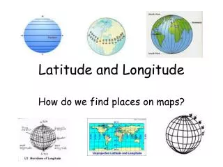
Notes Page: Latitude and Longitude-We use latitude and longitude to find a particular location on Earth latitude lines run horizontally. are also known as parallels and are an equal distances from each other. Degrees latitude are numbered from 0° to 90° north and south. Zero degrees is the equator, the imaginary line which divides our planet into the northern and southern hemispheres. The vertical longitude lines converge at the poles and are widest at the equator. Zero degrees longitude known as the Prime Meridian is located at Greenwich, England (0°). The degrees continue 180° east and 180° west where they meet and form the International Date Line in the Pacific Ocean.
East West, North South on The Earth • Let the X axis be the Equator. • Let the Y axis be the Prime Meridian that runs through Greenwich outside of London. • Lat/Long are the 2 grid points by which you can locate any point on earth. Y X
East West, North South on the Earth N • Let each of the four quarters then be designated by North or South and East or West. W E S
East West, North South on the Earth • The N tells us we’re north of the Equator. The S tells us we’re south of the Equator. • The E tells us that we’re east of the Prime Meridian. The W tells us that we’re west of the Prime Meridian. (N, W) (N, E) (S, W) (S, E)
East West, North South on the Earth • That means all points in North America will have a North latitude and a West longitude because it is North of the Equator and West of the Prime Meridian. (N, W) Prime Meridian
East West, North South on the Earth • What would be the latitude and longitude directions in Australia? ? Prime Meridian If you said South and East , you’re right!
What is Latitude? • Latitude is the distance from the equator along the Y axis, going N or S • All points along the equator have a value of 0 degrees latitude. • North pole = 90°N • South pole = 90°S • Values are expressed in terms of degrees. 90°N Y X 90°S
What is Latitude? • Each degree of latitude is divided into 60 minutes. • Each minute is divided into 60 seconds. 90°N Y X 90°S This is also true of longitude.
What is Latitude? • For Example: • 37°, 02’,51’’N 90°N Y X 90°S
What is Longitude? • Longitude is the distance from the prime meridian along the X axis, going E or W • All points along the prime meridian have a value of 0 degrees longitude. • The earth is divided into two parts, or hemispheres, of east and west longitude. Y X 180°W 180°E
What is Longitude? • The earth is divided into 360 equal slices (meridians) • 180 west and also 180 east of the prime meridian Y X 180°W 180°E
What is Latitude? • Our latitude and longitude might be: • 37°, 03’,13’’N • 76°, 29’, 45’’W 90°N Y X 90°S
So Where is (0,0)? • The origin point (0,0) is where the equator intersects the prime meridian. • (0,0) is off the western coast of Africa in the Atlantic Ocean.
See If You Can Tell In Which Quarter These Latitudes and Longitudes are located and label them on your map • 1. 30°N, 60°E • 2. 60°N, 120°W • 3. 45°S, 150°W • 4. 15°S, 30°W • 5. 75°N, 90°E • 6. 30°S, 105°E B A C D
Let's See How You Did! • 1. B • 2. A • 3. C • 4. C • 5. B • 6. D
See if you can find those same latitude/longitude locations on a map!
East is the direction of rotation of the Earth Latitude: (90oN to 90oS) Longitude: (180oE to 180oW) Prime Meridian 0o Longitude Tropic of Cancer Latitude 23½o North 21st June 66½o 90oE 60oE 30oW 30oE 60oW 90oW 23½o 90o 22nd Sept 20th March North Pole Equator Latitude 0o 23½o 900 22nd December Tropic of Capricorn Latitude 23½o South Longitude 90o West Longitude 90oEast Longitude 60o West Longitude 60o East Longitude 30o West Longitude 30o East South Pole Positioning on the Earth’s Surface Latitude and Longitude together enable the fixing of position on the Earth’s surface.
Notes Page: The Sun, the Tropics and the Poles The tropics are the two lines where the sun is directly overhead at noon on the two solstices . The sun is directly overhead at noon on the Tropic of Cancer 23.50 N on June 21 and the sun is directly overhead at noon on the Tropic of Capricorn 23.50 S on December 21 The area between the Tropic of Cancer and Tropic of Capricorn is known as the "tropics." This area does not experience seasons because the sun is always high in the sky.
Notes Page Time ZonesWhy do we need them? When it is dark and the middle of the night where you are, at some other place it is the early morning, somewhere else it is lunch time. Don't you think it would be pretty confusing to have it called "midnight" in all those places? • The Earth is divided into 24 time zones! • because the Earth Rotates • 1 Time zone for every 150 of Longitude • The Earth Spins 360 0 in 24 hours • 3600 /24 hours • We measure from The Prime Meridian in Greenwich England Every 15 0 to the East = +1 Hour Every 150 to the West = - 1 Hour
Sun Clock • World Time Zone • Time zones plus
4:00 PM If it is 4:00 PM in New York What time will it be in Iowa, Utah, and Oregon?