Download

1 / 5
50 likes | 73 Views
U.S. National Grid Location Marker Proposal. Over 33% of all requests for emergency assistance in the United States require a response at a location that does not have a formal street address….

E N D
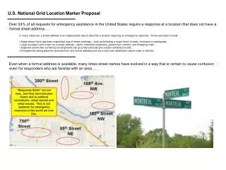
U.S. National Grid Location Marker Proposal • Over 33% of all requests for emergency assistance in the United States require a response at a location that does not have a formal street address…. • In many instances, a street address is an inappropriate way to describe a location requiring an emergency response. Some examples include: • Areas where there has been major/total loss of street markings – such as following a major flood, tornado, hurricane or earthquake. • Large acreage tracts known by a single address - parks, industrial complexes, government centers, and shopping malls. • Seasonal events like ice fishing encampments, fair grounds/carnivals and outdoor exhibits/concerts. • Emergencies taking place far removed from any formal address such as a rural train derailment, plane crash or wild fire. Even when a formal address is available, many times street names have evolved in a way that is certain to cause confusion - even for responders who are familiar with an area…..
Some traditional methods of formally describing a location simply aren’t interoperable, nor can they be easily used with Global Positioning System (GPS) receivers: Two different rural “fire numbers” for the same place. Colliding response grids – one side of the road versus the other! Two names for the same street …and/or try entering 23/24 ½ St. in a GPS.
Similarly, markings associated with hiking trails, off road routes and special transportation corridors often lack uniformity, and seldom, if ever, provide any indication of location.
For these reasons and many more like them, MnGeo's Emergency Preparedness Committee (EPC)is promoting adoption of the United States National Grid (USNG) as an alternative way for describing a location requiring an emergency response. • To complement these USNG adoption efforts, a standardized systemfor marking locations with USNG coordinates is being offered for consideration…for use when thought appropriate and desired. • Developed in partnership with geospatial experts inside and outside of Minnesota, and • Formulated after careful review of other actual and proposed USNG marker efforts such as……... Virginia USNG House Placard USNG Elevator Number/Location Marker Des Moines, Iowa USNG Trail Markers Texas Highway USNG Benchmarks
Martineau Off-Highway Motorcycle Trail USNG Marker USNG Bus Stop Location Markers • Download the latest USNG Location Marker – Minnesota “Best Practices” Proposal • http://www.mngeo.state.mn.us/committee/emprep/download/USNG/USNG_location_marker_proposal.html • Now available for review and consideration: USNG Location Marker - Minnesota "Best Practices" Proposal - Draft 2.3, • September 1, 2010 (12 p., 1.45 MB, PDF) • The document is divided into four main sections: • U.S. National Grid background • The proposal, with example graphics showing vertical and horizontal signs • Amplifying points, issues and suggested changes • Other information on the USNG • Also available for download is a 26-page revision history and received comments compendium that explains many of the issues that were considered while developing this project. Public Review Period Open Until October 22, 2010 Comments on the proposal are desired and encouraged. Please submit via email to Steve Swazee, chair of the Emergency Preparedness Committee, at steve.swazee@state.mn.us.