Download

1 / 84
840 likes | 862 Views
POPLAR RIVER, LUTSEN, MN. SEPARATING THE MEGA-SLIDE FROM THE RIVER (AND MORE). By the stream dream team.

E N D
POPLAR RIVER, LUTSEN, MN. SEPARATING THE MEGA-SLIDE FROM THE RIVER (AND MORE) By the stream dream team
Stream stabilization/restoration:Conceptually we will separate the stream from the hill, and in the channel we will make the inside of the bend smoother and the outer section of the stream rougher.
Stream stabilization/restoration methods:A Keyed, Minimal, Toe-Down Continuous Natural Boulder Revetment with Integrated Vegetation Combined with an Engineered Vegetated Mini-Swale combined with Bendway Weirs with pre-dug scour holes forming a pool-riffle-pool regime toward the inside of the bend with boulder fields between the Bendway Weirs. {Exhale here}
Stream Project Functions: Fully functioning both hydraulically & environmentally. Multiple protection redundancy. Revetment provides direct armor protection. Bendway Weirs and boulder fields move scour & thalweg away from attacked bank, with velocities reduced within the Bendway Weir field & boulder fields & on outer bank. Vegetation roughness reduces near-bank flow velocities. Roots strengthen bank & bind soil. Mini-swale captures up-slope colluvium from eroding slope.
PRE-PROJECT PHOTOSby Dave DerrickAUGUST 13, 2007(Lowest flow in almost 30 years)
Approximately 200 ft US of the project, looking US Derrick-8-13-2007-lowest flow in 30 yrs
Looking DS at the project, upper project limit is at red line Derrick-8-13-2007-lowest flow in 30 yrs
Looking at Mega slump. Note undercut mature veg. None of this will be fixed Derrick-8-13-2007
Looking DS. The DS end of the mega slump. Derrick-8-13-2007-lowest flow in 30 yrs
Looking US. Larger bed material on inside of bend will be relocated to the outside of the bend. Derrick-8-13-2007-lowest flow in 30 yrs
Stream Project Functions: Bendway Weirs move scour & the thalweg away from attacked bank, with velocities reduced within weir field & on bank. Vegetation roughness reduces near-bank flow velocities. Roots strengthen bank & bind soil. Mini-swale captures colluvium.
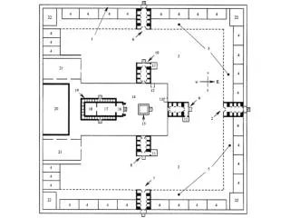
Mega Slump Mega- Slump Stream Project Planform Keys Boulder Revetment Bendway Weir Pre-dug Scour Holes Mini Swale Bridge Transplanted Veg
SUITABLE STONEStone used for toe protection & boulder fields was either natural stone from the stream or rounded medium-sized boulders in the 1,500 to 2,000 pound class. Stone for the Bendway Weirs were extremely large rounded boulders, most from the quarry, typically 4 ft by 5 ft by 6 ft. Stone for keys was a mix of native medium boulders, very large rounded boulders from the quarry, & gravel-cobble-small boulder “choke” stone from the stream.
CONSTRUCTION PHOTOSby Dave Derrick and Jay MichelsAUGUST 5-8, 2008
A KEY HAS ONE MAIN JOB, TO CONNECT THE RIVER TRAINING STRUCTURE TO THE REST OF THE WORLD (DON’T LET THE STREAM GET BEHIND {FLANK} RIVER TRAINING STRUCTURES)
Stream stabilization/restoration:All keys will be trenched perpendicular to the stream into the bank. One side of each key trench will be lined with adventitious rooting willow poles (harvested locally). All keys will use a gravel filter (harvested from the stream), with the key constructed of a mix of monster boulders & well-graded stone (from both the stream and quarry). Stone will then be choked with soil & seeded.
Detail for keys for the Bendway Weirs & the Minimal Stone Toe Protection Cross-section for keyway
Jay Michels cut about 1,000 willow from near the sewage treatment ponds at the top of the hill for planting within the project. CONSTRUCTION-POPLAR RIVER @ MEGA-SLUMP-PIX BY JAY MICHELS 8/08
Detail for keys for the Bendway Weirs & the Minimal Stone Toe Protection Place Willow Poles against one side of the trench Granular filter
Dave Derrick in key trench placing large willow poles on DS side of trench Deeply planted willows oriented perpendicular to flow will act as a “Living Dike”, slowing near-bank flow velocities. CONSTRUCTION-POPLAR RIVER @ MEGA-SLUMP-PIX BY JAY MICHELS 8/08
Detail for keys for the Bendway Weirs & the Minimal Stone Toe Protection Place stone in trench
Detail for keys for the Bendway Weirs & the Minimal Stone Toe Protection Choke stone with gravel (white areas) & water in to settle choke material & water poles
Robust key starting to look good!! CONSTRUCTION-POPLAR RIVER @ MEGA-SLUMP-PIX BY DERRICK 8/5-8/2008
Backfill and overfill with native soils, then compact (some settling will still occur over time) Detail for keys for the Bendway Weirs & the Minimal Stone Toe Protection
Key complete except for seeding & mulch. Willow poles will be trimmed (approx. 2/3 of pole in ground, 1/3 out of ground). CONSTRUCTION-POPLAR RIVER @ MEGA-SLUMP-PIX BY DERRICK 8/5-8/2008
Detail for keys for the Bendway Weirs & the Minimal Stone Toe Protection Seeding was accomplished the day after we left DONE
Dave Derrick setting the upstream angle of the Bendway Weir #5 (20 degrees upstream from perpendicular, or in other words 70 degrees from the bank). All Bendway Weirs were angled 20 degrees upstream. CONSTRUCTION-POPLAR RIVER @ MEGA-SLUMP-PIX BY JAY MICHELS 8/08
From top of key looking down @ hoe digging into streambed so that large stones for the Bendway Weir can be placed at the proper elevation. CONSTRUCTION-POPLAR RIVER @ MEGA-SLUMP-PIX BY DERRICK 8/5-8/2008
From key looking @ hoe placing first stone (that will abut the key that was just built) for Bendway Weir #1. CONSTRUCTION-POPLAR RIVER @ MEGA-SLUMP-PIX BY DERRICK 8/5-8/2008
Bendway Weir will be angled toward trees behind hoe bucket. CONSTRUCTION-POPLAR RIVER @ MEGA-SLUMP-PIX BY DERRICK 8/5-8/2008
Looking DS @ constructed mini-weir & Bendway Weir #1. Constructed boulder field to left & pool-riffle-pool complex on right side of channel. CONSTRUCTION-POPLAR RIVER @ MEGA-SLUMP-PIX BY DERRICK 8/5-8/2008
Looking DS @ constructed mini-weir & Bendway Weir #1. Note constructed boulder field & pool riffle-pool complex on right side of channel CONSTRUCTION-POPLAR RIVER @ MEGA-SLUMP-PIX BY DERRICK 8/5-8/2008
Looking straight at Bendway Weir #1. Jay shooting as-built elevations. Note complex flow. CONSTRUCTION-POPLAR RIVER @ MEGA-SLUMP-PIX BY DERRICK 8/5-8/2008
CONSTRUCTION PIX OF SEVERAL SECTIONS OF THE LONGITUDINAL STONE TOE PROTECTION
Minimal Toe-Down Continuous Natural Appearing Boulder Revetment:Large & small boulders from stream & quarry were placed to form a continuous longitudinal revetment constructed to a height equal to the Q-1.5 flow event plus 2.75 ft (minimum). Revetment has 10-15 ft long vegetated stone keys that tie into the bank. Keys will be located at the end of each Bendway Weir. Bendway Weir spacing varies from 41 to 79 ft.
A smooth path was cleared on the left side of the channel so that equipment could traverse the length of the project. This stone was placed in the right side of the channel. CONSTRUCTION-POPLAR RIVER @ MEGA-SLUMP-PIX BY DERRICK 8/5-8/2008
THE MEGA-SLUMP FAILURE ON THE POPLAR RIVER, MN Eroding bank Stream channel 1 of 8
THE MEGA-SLUMP FAILURE ON THE POPLAR RIVER, MN Existing earth loosened & some soil-gravel added in preparation for planting. 2 of 8
THE MEGA-SLUMP FAILURE ON THE POPLAR RIVER, MN Willow pole plantings (in bunches) at intervals Willow poles will be laid against the bank. Basal ends should be in vadose zone (capillary zone) 3 of 8
At intervals soil was loosened, willow poles were placed against the bank & soil placed over the lower half of the willow poles. CONSTRUCTION-POPLAR RIVER @ MEGA-SLUMP-PIX BY DERRICK 8/5-8/2008
THE MEGA-SLUMP FAILURE ON THE POPLAR RIVER, MN Rounded boulders from both the stream & quarry will be used as a continuous longitudinal revetment. 4 of 8
Looking DS @ the first section of longitudinal toe we constructed. It is too uniform. We will deconstruction this section & build in more chaos !!!!! CONSTRUCTION-POPLAR RIVER @ MEGA-SLUMP-PIX BY DERRICK 8/5-8/2008
Looking DS @ the smooth stone revetment in foreground & more chaotic stone toe immediately past the very large boulder CONSTRUCTION-POPLAR RIVER @ MEGA-SLUMP-PIX BY DERRICK 8/5-8/2008
Mini swale can catch colluvium from eroding upper bank THE MEGA-SLUMP FAILURE ON THE POPLAR RIVER, MN 5 of 8
Looking DS @ the mini-swale landward of the crest of the toe stone that will capture mass wasted material (colluvium) from the unimproved mega-slide. CONSTRUCTION-POPLAR RIVER @ MEGA-SLUMP-PIX BY DERRICK 8/5-8/2008
THE MEGA-SLUMP FAILURE ON THE POPLAR RIVER, MN County Soil & Water is considering planting 200 rooted stock plants on the Mega-Slump 6 of 8