Ch 9 - Thunderstorms
Ch 9 - Thunderstorms. Ch 9 - Thunderstorms. Introduction In this chapter, we continue our “scale approach” to the understanding of atmospheric circulations. Moving to smaller scales, our consideration is now the mesoscale phenomena known as a thunderstorm.

Ch 9 - Thunderstorms
E N D
Presentation Transcript
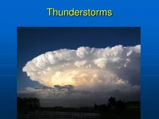
Ch 9 - Thunderstorms • Introduction • In this chapter, we continue our “scale approach” to the understanding of atmospheric circulations. • Moving to smaller scales, our consideration is now the mesoscale phenomena known as a thunderstorm. • The thunderstorm is one of the most spectacular atmospheric circulations, and one that you must respect as a pilot. • It can be bright, loud, violent, and dangerous in many ways (Lester, 2006).
Ch 9 - Thunderstorms • Introduction • As with our study of macroscale circulations, we will begin with an idealized model of the thunderstorm. • When you complete this chapter, you will understand thunderstorm structure and behavior as well as the wide variety of microscale phenomena that are frequently produced by a thunderstorm (Lester, 2006).
Ch 9 - Thunderstorms • Introduction • You will also become familiar with larger mesoscale and macroscale circulations that provoke thunderstorms and organize them into lines and clusters. • A thunderstorm is always a threat to aircraft operations. • A wise pilot will be sure he or she understands the what? Why? And where? Of thunderstorms (Lester, 2006).
Ch 9 - Thunderstorms • Section A – Dry Convection • Section B – Cloudy Convection • Cloud Growth • Downdraft Development • Section C – Weather Radar • Lightning Detection Equipment
Ch 9 - Thunderstorms • Section D – Thunderstorm Structures • Thunderstorm Types • Airmass Thunderstorm • Multicell Thunderstorm • Supercell Thunderstorms • Tornadoes • Hail • Lightning
Ch 9 - Thunderstorms • Section E – Thunderstorm Environment • Requirements for Development • Climatology • Instability Patterns • Thunderstorm Lines • Macroscale Fronts • Squall Lines • Other Mesoscale Lines • Thunderstorm Clusters • Macroscale Clusters • Mesoscale Convective Complexes
Ch 9 - Thunderstorms • Section A: Dry Convection • Dry convection – air in the cumulus clouds or cumulonimbus clouds originally comes from the boundary layer • a common process within a few thousand feet of the ground • Thermals – the cloudless roots of cumulus clouds • Dust devils – the result of the spin-up of a thermal is a vortex known as a whirlwind or dust devil not to be confused with more violent tornadoes or waterspouts
Ch 9 - Thunderstorms • Vortex ring – superimposed on the overall rising motion of the thermal is a microscale circulation cell that is best described as an elongated vortex ring. • Extending upward from the ground, the vortex ring has a relatively narrow core of upward motions surrounded by a broad region of weaker sinking motions.
Ch 9 - Thunderstorms • Section B: Cloudy Convection • Cloudy convection – in its most common use the term cloudy convection refers to saturated air that is rising because it is warmer than its surroundings • Convective condensation level – the characteristic flat bases of the clouds occur at the altitudes where the rising unstable air first reaches saturation and is called the convective condensation level. • Equilibrium level – the cloudy updraft continues its upward acceleration until it reaches its equilibrium level; that is, the altitude where the updraft temperature is equal to the temperature of its surroundings.
Ch 9 - Thunderstorms • ****STRONG UPWARD CURRENTS IN CLOUDS ENHANCE THE GROWTH RATE PRECIPITATION****
Ch 9 - Thunderstorms • Precipitation-induced downdraft – when the altitude of the cumulus cloud exceeds the freezing level, there is a rapid growth of cloud particles by the ice crystal process. • At some point in this process the updraft is no longer strong enough to support the weight of the large particles. • They begin to fall dragging air downward. • This is the beginning of the precipitation-induced downdraft.
Ch 9 - Thunderstorms • Radar – weather radar is used extensively to locate thunderstorms and to observe their structure and behavior. • Radar for radio detection and ranging is an instrument that uses electromagnetic radiation to detect objects and determine their distance and direction from the radar site.
Ch 9 - Thunderstorms • Radar echo – a small fraction of the reflected / scattered radar signal returns to the radar antenna / receiver where it is intercepted. • The received signal constitutes a radar echo. • Doppler radar – has the capacity to determine velocity of a target toward or away from the radar by measuring the frequency difference between the transmitted and received radiation. • Weather radar – operates at specific frequencies or wavelengths of electromagnetic radiation that are sensitive to scattering by ice and water particles.
Ch 9 - Thunderstorms • WSR-88D (NEXRAD) – the United States weather radar network has been upgraded over the last several years with an improved Weather Surveillance Radar. This is a powerful Doppler Radar System. • Airborne weather radar – not as powerful as surfaced based radar, airborne weather radar has the advantage of observing the current conditions ahead of the aircraft • Attenuation – as a radar signal travels away from its source, it undergoes a process known as attenuation. This is a weakening of the signal that occurs as the signal absorbed, scattered, or reflected along its path.
Ch 9 - Thunderstorms • ****THE RADARSCOPE PROVIDES NO ASSURANCE OF AVOIDING INSTRUMENT WEATHER CONDITIONS****
Ch 9 - Thunderstorms • Radar Summary Chart – An example of the radar echo intensity information available every hour from the national radar network is shown on a weather radar summary chart. • Radar Summary Charts show weather radar echo intensity scales as a measure of precipitation rate. • Contours represent radar echo intensity levels1, 3, and 5. • See power point presentation on Radar Summary Charts for additional information
Ch 9 - Thunderstorms • Radar Summary Charts give the following information: • ECHO (PRECIPITATION) TYPE • INTENSITY • ECHO CONFIGURATION AND COVERAGE • ECHO TOPS • ECHO MOVEMENT • SEVERE WEATHER WATCH AREAS
Ch 9 - Thunderstorms • Constant Pressure Analysis Charts - Weather information for computer generated constant pressure charts is observed primarily by balloon-ascending radiosonde packages. • Each package consists of weather instruments and a radio transmitter. • During ascent instrument data are continuously transmitted to the observation station. • Radiosondes are released at selected observational sites across the USA at 00Z and 12Z.
Ch 9 - Thunderstorms • The data collected from the radiosondes are used to prepare constant pressure charts twice a day. • Constant pressure charts are prepared for selected values of pressure and present weather information at various altitudes. • The standard charts prepared are the 850 mb (hPa), 700 mb (hPa), 500 mb (hPa), 300mb (hPa), 250 mb (hPa), and 200 mb (hPa) charts. • Charts with higher pressures present information at lower altitudes while charts with lower pressures present information at higher altitudes.
Ch 9 - Thunderstorms • Constant Pressure Analysis Charts give the following information: • All constant pressure charts contain analyses of height and temperature variations. • Contours are drawn as solid lines on constant pressure charts and are identified by a three-digit code located on each contour.
Ch 9 - Thunderstorms • Isotherms are lines of constant temperature. • Isotachs are lines of constant wind speed. • Constant pressure charts are used to provide an overview of selected observed en route flying conditions. • See power point presentation on Constant Pressure Analysis Charts for additional information
Ch 9 - Thunderstorms • Lightning detection equipment – very popular alternative to airborne radar for light general aviation aircraft. • The equipment is designed to help the pilot completely avoid storm cells. • However, this equipment does not directly indicate any areas of heavy precipitation, hail or wind shear.
Ch 9 - Thunderstorms • Thunderstorm – based on surface observations, a thunderstorm is defined as a local storm produced by a cumulonimbus cloud and always accompanied by lightning and thunder. • Airmass thunderstorm – an ordinary thunderstorm • Severe thunderstorm – a severe thunderstorm has a greater intensity than an airmass thunderstorm as defined by the severity of the weather it produces: wind gusts of 50 knots or more and/or hail three-quarters of an inch or more in diameter and/or strong tornadoes.
Ch 9 - Thunderstorms • Single-cell airmass thunderstorm – lasts less than one hour • Supercell severe thunderstorm – may last two hours or longer • Multicell thunderstorm – a multicell storm is a compact cluster of thunderstorms
Ch 9 - Thunderstorms • Cumulus stage – when atmospheric moisture and instability are sufficient the evolution of the airmass thunderstorm begins. • In the cumulus stage an important change occurs in the nature of convection. • There is a marked increase in the scale of the circulation. • The size of the updraft region becomes larger than the size of any of the individual thermals that are feeding the region.
Ch 9 - Thunderstorms • Towering cumulus (TCU) – during the cumulus stage, the convective circulation grows rapidly into a towering cumulus (TCU) cloud which typically grows to 20,000 feet in height and three to five miles in diameter. • The cloud reaches the next stage of development in about 15 minutes.
Ch 9 - Thunderstorms • ****A CONTINUOUS UPDRAFT IS NORMALLY ASSOCIATED WITH THE CUMULUS STAGE OF A THUNDERSTORM**** • ****AN INDICATION THAT DOWNDRAFTS HAVE DEVELOPED AND THAT THE THUNDERSTORM CELL HAS ENTERED THE MATURE STAGE IS WHEN PRECIPITATION BEGINS TO FALL FROM THE CLOUD BASE**** • ****THUNDERSTORMS REACH THEIR GREATEST INTENSITY DURING THE MATURE STAGE**** • ****IN THE LIFE CYCLE OF A THUNDERSTORM, THE DISSIPATING STAGE IS DOMINATED BY DOWNDRAFTS****
Ch 9 - Thunderstorms • Shelf Cloud – a shelf cloud often indicates the rising air over the gust front • Outflow boundary – an outflow boundary is the remnant of a gust front that continues to exist long after the thunderstorm that created it have dissipated. • Supercell – this thunderstorm type almost always produces one or more of the extremes of convective weather: very strong horizontal wind gusts and/or large hail and/or strong tornadoes. This is due to thunderstorm structure
Ch 9 - Thunderstorms • Wall cloud – a portion of the rain-free cloud base may appear lower in what is called a wall cloud • Mammatus – the bulges that appear under the anvil of a thunderstorm • Tornado – a violently rotating column of air which is found below cumulonimbus clouds • Funnel cloud – a tornado which does not reach the surface
Ch 9 - Thunderstorms • Water spout – a tornado that occurs over water • Gustnadoes – near gust fronts and the edges of downbursts, tornado-like vortices known as gustnadoes sometimes occur • Cold air funnel – a cold air funnel is a weak vortex that occasionally develops after a cold front passage in association with rain shower and / or thunderstorm activity. • Hail – another product of strong upward motions; as snow collides with water droplets the droplets freeze in the process known as accretion. In a thunderstorm, accretion may produce a larger particle that becomes the nucleus of a hailstone. • Lightning – the visible electric discharge produced by a thunderstorm
Ch 9 - Thunderstorms • ****LIGHTNING IS ALWAYS PRESENT IN (AND NEAR) A THUNDERSTORM
Ch 9 - Thunderstorms • Stepped leader – the lightning stroke is actually a series of events which begins with a nearly invisible stepped leader that carries electrons from the base of the cloud to the ground, creating an ionized channel for the subsequent discharge • Return stroke – a bright return stroke occurs, marking the route of the positive charge along the original path of the stepped leader, back up into the cloud • Dart leaders – the initial discharge is often followed by several so-called dart leaders and more return strokes
Ch 9 - Thunderstorms • Initial lift – when the surface layer is lifted a sufficient distance, strong convection occurs. • Initial lifting is the minimum amount of vertical displacement necessary to release the instability.
Ch 9 - Thunderstorms • ****THE CONDITIONS NECESSARY FOR THE FORMATION OF CUMULONIMBUS CLOUDS ARE MOIST, UNSTABLE AIR AND A LIFTING ACTION****
Ch 9 - Thunderstorms • Lifted index – a practical approach to the evaluation of the potential instability requirement for thunderstorms is to use a stability index. • The lifted index is the difference between the observed 500 mb (~18,000 feet) temperature and the temperature that a parcel of air would have if lifted from near the earth’s surface to the 500 mb level. • Lifted index (0 – 2) = weak chance of severe thunderstorm • Lifted index (-3 – -5) = moderate chance of severe thunderstorm • Lifted index (< = -6) = strong chance of severe thunderstorm
Ch 9 - Thunderstorms • ****THE LIFTED INDEX IS THE TEMPERATURE DIFFERENCE FOUND BY SUBTRACTING THE TEMPERATURE OF A PARCEL OF AIR THEORETICALLY LIFTED FROM THE SURFACE TO 500 MILLIBARS FROM THE EXISTING TEMPERATURE AT 500 MILLIBARS****
Ch 9 - Thunderstorms • Squall line – a squall line or instability line is a broken or continuous line of thunderstorms not necessarily associated with a front.
Ch 9 - Thunderstorms • ****EMBEDDED THUNDERSTORMS ARE THUNDERSTORMS THAT ARE OBSCURRED BY MASSIVE CLOUD LAYERS AND CANNOT BE SEEN**** • ****THE MOST SEVERE WEATHER CONDITIONS, SUCH AS DESTRUCTIVE WINDS, HEAVY HAIL, AND TORNADOES ARE GENERALLY ASSOCIATED WITH SQUALL LINES****
Ch 9 - Thunderstorms • ****SQUALL LINES ARE NOT NECESSARILY ASSOCIATED WITH FRONTS AND MAY CONTAIN EITHER OR BOTH AIRMASS AND SEVERE THUNDERSTORMS**** • ****SQUALL LINES MOST OFTEN DEVELOP AHEAD OF A COLD FRONT****
Ch 9 - Thunderstorms • Dry line – the moisture boundary which is called a dry line is apparent in the distribution of surface dew point temperatures • Mesoscale convective complexes – These are nearly circular clusters of thunderstorms that develop primarily between the Rockies and the Appalachians during the warmer part of the year.