Download
1 / 10
100 likes | 245 Views
NOAA Satellite Proving Ground OCONUS Meeting 6/20/2013 Training. Brian Motta National Weather Service Training Division Forecast Decision Training Branch Brian.Motta@noaa.gov 303-497-6561. Content Summary. Issue 1, slide 3: GOES-R Fog and Low Stratus Products: Implementation

E N D
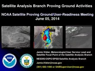
NOAA Satellite Proving GroundOCONUS Meeting 6/20/2013Training Brian Motta National Weather Service Training DivisionForecast Decision Training Branch Brian.Motta@noaa.gov 303-497-6561
Content Summary Issue 1, slide 3: GOES-R Fog and Low Stratus Products: Implementation Issue 2, slide 4: VISIT Calendar and Status Issue 3, slide 5: Fire Weather Proving Ground Activity @ BOU Issue 4, slide 6: NWS Operational Implementation of ENI Total Lightning Issue 5, slide 7: NASA GPM Mission Issue 6, slide 8: Miscellaneous But Important Issue 7, slide 9: AWIPS2 OT&E Testing and Deployment Status IaImp
GOES-R Fog and Low Stratus Products: Implementation • Michael Pavolonis, NESDIS Develops FLS Products, GOESR AWG PI • Products made available in AWIPS1 via GEOCAT server and LDM • CR Operational Evaluation 1 August – 31 December 2012 (Chad G.) • VISIT Reviews and Delivers GOES-R FLS Training Nationally (Scott L.) • SR Weather Ready Nation Pilot Project Use (Chad G. SSW Presentation) • Jordan Gerth & Matt Foster@ Central Region HQ develop AWIPS2 ATAN • AWIPS2 testing at CRH finds discrepancies • AWIPS2 Discrepancy Reports Issued for RegSat Plugin and ColorTables • GOES-R FLS Clears NWS OPG • Kevin Schrab (NWS Obs Services Chief) requests FLS Products from NESDIS….triggering NESDIS SPSRB process (May 9, 2013) • ______ • NESDIS SPSRB Process Completes • NESDIS Product/System Development Implementation (PSDI) Project • AWIPS SREC Requests for Software Modifications to AWIPS2 Baseline • AWIPS Engineering for Data Flow (Gockel) • Testing of Data Flows from NESDIS to AWIPS SBN • Operational GOES-R FLS Products Nirvana • New wrinkle, path forward to include SNPP/VIIRS FLS Products ?
VISIT Calendar and Status June/July VISIT Calendar 2013 Update to Tropical Cyclone Track Model Guidance used by NHC (June 25) 2013 Update to Tropical Cyclone Intensity Guidance used by NHC (July 2) GOES-R Fog and Low Stratus Products (June 26, July 9, 18, 24) GOES Imagery for Forecasting Severe Weather (June 25, July 16) SNPP VIIRS Satellite Imagery in AWIPS (July 3, 8, 24, 25) Convective Downbursts (July 10) Convective Cloud Top Cooling (July 11) Mesoscale Convective Vortices (June 25, July 18, 23) Synthetic Imagery for Forecasting Severe Weather (June 26, July 11) Status: NWS funding for VISIT CI FTEs ceases on July 1, 2013
Fire Weather PG Activity @ WFO BOU • Supported WFO PUB during Black Forest Wildfire (509 homes lost, 2 fatalities) • New wildfire, Lime Gulch, believed to be lightning-caused, in Jefferson County…west of Denver Metro • Air Quality concerns today, State of Colorado issued AQ Alert for Denver Metro and Front Range • Forecasters making extensive use of Colorado LMA data…both for fires and severe thunderstorm/tornado warnings on Situation Awareness Displays • Forecasters used SNPP DNB imagery to monitor fire and smoke plume during overnight hours. • Evaluated LMA flash density imagery in GE but implementation and display needs refinement.
New Lightning Data & GOES-R Lightning Mapper Proxy Products • Earth Networks Inc. Total Lightning Data made available to each office, initially via Weatherbug Professional web interface for demonstration/evaluation last year and “operationally” starting Fall 2012. • Currently, OST is working with SPC, AWC, SPoRT, GSD, other lightning experts, and AWIPS program to specify what ENI Total Lightning Data or products should become available in AWIPS. • Awaiting ENI answers to many operational network questions. Empirical studies have found important network variations in detection efficiency and other basic network performance. • ENI Total Lightning point data could be used to make GOES-R GLM Proxy data for user readiness familiarization and training. • Needs Hazardous Weather Testbed evaluation. Main benefit appears to be 20-30 minute lead time over CG detection. • AWIPS2 ATAN approved for Total Lightning Mapping Array data for HUN, HOU. FDTB, WDTB, SPoRT collaborating on total lightning training plan. • New ESRL/GSD proposal to accelerate R2O for current total lightning data visualization, analysis and derived outputs into operational AWIPS at selected prototype sites. Awaiting review and response.
NASA Global Precipitation Measuring Mission • NOAA (NESDIS and NWS) recently held a workshop on GPM and have just published a report. • Mission readiness, user education, and training were primary goals. • Opportunity to develop new science around the QPE/QPI observation and estimation using integrated remote sensing capabilities. • Core team forming with NWS OHD, NESDIS STAR, and CI staff. • Questions: • Now is a key time for planning, how does AR and PR want to be involved ? • What role(s) can GOES-R play during the GPM mission ? • How can SNPP and JPSS be exploited optimally to move forward with satellite-based, satellite-trained, improved techniques for QPE/QPI ? • Does SPoRT have any plans for the GPM Mission ? • Does NWS plan to utilize NASA GPM to support operations ? • What operational hydrologic applications will GPM support for RFCs and WFOs ?
Miscellaneous Items • NESDIS and NWS hold a quarterly forum to discuss current NOAA Satellites’ status, user needs, data access, etc. Contact me for more info…available remotely • Started interaction and discussion thread on the Galena, AK ice jam flooding. CIMSS Blog entries and imagery posted. Email discussion with Robin Radlin • Working with MJ/OST on OSCAT OSWVs options for AWIPS1 and AWIPS2. • WDTB recently received funding to integrate GOES-R content into the Advanced Warning Operations Course for 1) Severe Weather, 2) Winter Weather, 3) Flash Flood. However, NWS funding for 7 WDTB/CIMMS employees ceases on July 1, 2013. • NWS sent unfunded training to CFO for Sandy Supplemental funding consideration. • COMET staff reductions of 7 have also occurred due to funding reductions in 2013.
AWIPS2 OT&E Testing and Deployment Status Performance and Stability Testing to Exit OT&E has not officially started. Delays since March 2013 to fix Critical 1 DRs, TTs WFO BOU currently at Build 13.3.1-34 with patches 35 and 36 expected to be installed in the next week. That means 34 corrections have been made to the original 13.3.1 software build.
NOAA Satellite Proving GroundOCONUS Meeting 6/20/2013Training Brian Motta National Weather Service Training DivisionForecast Decision Training Branch Brian.Motta@noaa.gov 303-497-6561