Download
1 / 21
210 likes | 379 Views
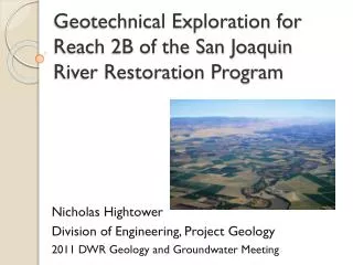
Geotechnical Exploration for Reach 2B of the San Joaquin River Restoration Program. Nicholas Hightower Division of Engineering, Project Geology 2011 DWR Geology and Groundwater Meeting. Background. The San Joaquin River Restoration Program is the result of a Settlement which has two goals:

E N D
Geotechnical Exploration for Reach 2B of the San Joaquin River Restoration Program Nicholas Hightower Division of Engineering, Project Geology 2011 DWR Geology and Groundwater Meeting
Background • The San Joaquin River Restoration Program is the result of a Settlement which has two goals: • Restoration Goal: To restore and maintain river flows to help reproduce and sustain populations of salmon and other fish • Water Management Goal: To reduce and avoid adverse water supply impacts on water contractors due to interim and restoration flows. • The US Bureau of Reclamation is the lead federal agency, while DWR is the lead state agency for the program. South Central Region Office is the lead for DWR.
SJRRP DESCRIPTION • LOCATION • 150 miles of the San Joaquin River from Friant Dam (Millerton Lake) to the confluence with the Merced River • Also includes 13 miles of the Eastside and Mariposa Bypasses • COMPONENTS • 350 miles of existing and new levees • 8 control structures • 8 river crossing structures • Seepage monitoring • Borrow areas
Reach 2B Geotechnical Investigation • DWR and the Bureau of Reclamation is responsible for gathering geotechnical data to support the alternative channel alignment designs • USBR: Focused efforts on groundwater seepage • DWR: Geologic exploration and analysis to support engineering design of proposed modifications to increase the San Joaquin River channel carrying capacity, along with accompanying structures.
Reach 2B Exploration • Reach 2B is about 35 miles west of Fresno
South Central Region Office • Secured TEPs and notified landowners with Right-of-Way’s assistance • Coordinated and performed Environmental and Cultural Clearances • Created and provided essential GIS mapping • Marked/Staked hole locations prior to clearances • Requested underground utility clearances from USA • SCRO Field Staff helped log holes and coordinate the field effort
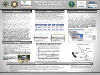
2010 Geotechnical Exploration • Completed in three separate phases: • March • June • November-December • 21 Borings range in depth from 50 to 64 feet • 72 CPTs range in depth from 60 to 90 feet.
2010 Geotechnical Exploration (Continued) • Drilling • 20 borings drilling using mud rotary methods because of heaving sands • 1 boring drilled using hollow-stem auger method • Standard Penetration Tests conducted every five feet with sample bagged • Two thin-walled Shelby tube samples typically collected from each boring for potential shear strength, permeability, compaction, and other geotechnical tests
Cone Penetration Testing • 72 soundings • Continuously measured tip resistance, sleeve friction, and dynamic pore pressure • Pore pressure dissipation tests conducted at selected depths in each sounding to determine depth to groundwater • Used as primary exploration, with lithology confirmed at selected locations with paired drill holes
2010 Geotechnical Exploration • Borings and CPTs were placed at locations where specific design and foundation information was needed
Post-Field Work—Office Time • First Step: Review Field Drilling Logs • Entered logs into gINT, a borehole database program • gINT has multiple functions: • Creates official logs • Stores soils data in database • Allows data export to Microsoft Excel
Creating Cross-Sections in ArcGIS • Export borehole data from gINT into Excel format for ArcGIS, along with CPT logs • Draw desired cross-section lines in map view
FINDINGS • The CPT logs correlated well on the majority of the borings. • Soil lab tests are still in the process of being tested. • The general soil stratigraphy can be summarized as: • 0-5’ Silty Sand and Silt • 5-20’ Sandy Clay, Clay and Silt • 20-60’ Silty Sand and Poorly Graded Sand
CONCLUSIONS • First phase of exploration for Reach 2B resulted in sufficient geotechnical data to begin preliminary design. • Additional exploration will be necessary to go forward with more detailed design, and to explore conditions for specific structures and borrow areas. • The use of gINT for boring logs makes drill hole data more useable and manageable. • The use of ArcGIS and CrossView makes compilation of geologic cross sections efficient and easy for data analysis and presentation.