Understanding Model Development in Geosciences: Concepts and Applications
360 likes | 498 Views
This text outlines the fundamentals of model development within geosciences, focusing on types of models, their purposes, and protocols for effective model creation. It highlights the significance of predictive, interpretive, and generic applications in analyzing systems and processes. Key methodologies for data collection, including hydrologic, geologic, and geophysical data, are discussed. The framework for ensuring effective model performance includes defining problems, conceptual and mathematical modeling, and addressing uncertainties while embracing heterogeneity and anisotropy for accurate simulations.

Understanding Model Development in Geosciences: Concepts and Applications
E N D
Presentation Transcript
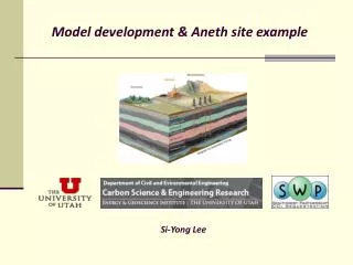
Model development & Aneth site example Si-YongLee
What is a model? A model is a simplified representation of reality or any device that represents a system.
Why model? • Predictive application • (predicting the consequences of a proposed action) • Interpretive application • (understanding system dynamics) • Generic application • (analyzing processes in generic/hypothetical settings)
What types of models? Conceptual Model: Qualitative description of system Mathematical Model: Mathematical description of system - Analytical solution - Numerical solution Physical Model: e.g. core flooding experiment
Modeling Protocol Define Problem Conceptual model Mathematical model Model Redesign Computation Model Calibration Comparison with field data Results
Define the problems/objectives • Site selection - storage capacity - Injectivity - Plume distribution (AOR) • Monitoring design • Uncertainty/Risk assessment
Data Collection • Hydrologic data (local & regional) • Geologic data (e.g., stratigraphy, formation tops, faults/fractures, tectonic information, and seismic events) • Geophysical data (e.g., well logs, seismic survey) • Rock properties (por, perm, relative perm, Pc, bulk density, Young’s modulus, Poisson’s ratio, mineralogy, etc) • Fluid properties (salinity, pH, density, viscosity, mutual solubility, brine chemistry, isotope, etc) • Well information (location, vertical/horizontal, perforation interval, injection/production history, bottom hole pressure, etc)
Conceptual Model Cross-bedded aeolian Navajo Ss (outcrop in Devil’s canyon, UT) Conceptual model of the cross-bedded bedform 3D cross-bedded bedform Grain flow (dune) Wind ripple (interdune)
Grid building • An optimally-sized model domain should : • Encompass all the major flow units (formations of interest – injection zone, overlying and underlying formations) • - Include the injection, monitoring, and any production wells • - Lie within the extent of pressure response area • - Be tractable computationally
Grid resolution (dx, dy, dz) • Grid resolution vs. computational efficiency • Should include heterogeneity, well configuration, and sufficient accuracy in the changes of results (pressure & saturation). Coarsening of model grid further from the injection well (no more than 1.5 times the previous nodal spacing). Grid coarsening could create numerical dispersion.
Assigning property parameters • Single value in a cell (REV, scale issue) • Sparse data in space (especially horizontal direction) • Heterogeneity • Property upscaling
Heterogeneity and Aniostropy Heterogeneity : Variations through space Aniosotropy : Variations with the direction of measurement at any given point
Heterogeneity and Aniostropy Homogeneous, Isotropic Homogeneous, Anisotropic ( kz (x2,z2) kx (x1,z1) Heterogeneous, Anisotropic Heterogeneous, Isotropic
Approaches to generate heterogeneity Deterministic approach: parameter values are known with certainty (single solution) Stochastic approach: uncertainty in parameter values (ranges in solution) Layer Cake Model Actual Geology Stochastic/Geostat. Model
Stochastic Approaches • Continuous Heterogeneity • Gaussian model (mean, variance, and variogram) • Fractal model • Discrete Heterogeneity • Facies model with indicator geostatistics • Depositional simulation • Process imitation (mathematically-based equations) • Structure imitation (probabilistically-based) • Mixed Heterogeneity (continuous + discrete)
TProGS Realization (TPROGS1)
TProGS Realization (largest connected channel body) (TPROGS1)
SGS Realization (GAUSS1)
SGS Realization (largest connected body) (GAUSS1)
Geologic Model Development in Aneth site - Data Acquisition - Petrophysical Properties Estimation Estimation of porosity Porosity & Permeability Relationship - Geologic Model Development
Data Acquisition • Core plug analyses • (porosity, density, and permeability) • - Geophysical well log images • - Stratigraphic formation tops data • - Well information • - Injection/production history
Entrada Navajo Kayenta Wingate Chinle Dechelly Organ Rock Hermosa Ismay Gothic Desert Creek
Porosity Field (n=9,170,238; dx=dy=100m, dz=1m; nz=1,644)
Upscaled Porosity Field (n=227,950; dx=dy=100m; nz=41)
Permeability Field (n=227,950; dx=dy=100m; nz=41)