Download
1 / 26
260 likes | 506 Views
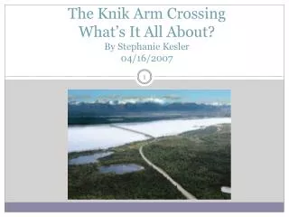
The Knik Arm Crossing What’s It All About? By Stephanie Kesler 04/16/2007. What It’s Really All About. Commute Time and Distance Realities Risky and Uncertain Financials Flawed Traffic Modeling Robs funding from other critical road projects. Impacts on Mat-Su, Anchorage, and Cook Inlet.

E N D
The Knik Arm CrossingWhat’s It All About?By Stephanie Kesler04/16/2007
What It’s Really All About Commute Time and Distance Realities Risky and Uncertain Financials Flawed Traffic Modeling Robs funding from other critical road projects. Impacts on Mat-Su, Anchorage, and Cook Inlet
The Knik Arm Crossing in 45 Minutes or Less Knik Arm Crossing 101 – a crash course in five slides. Routes and Commute Times Money, Money Money – Costs, Funding, and Tolls Impacts on Mat-Su, Anchorage, and Cook Inlet. Questions to Ask KABATA
Knik Arm Crossing 101Acronyms KABATA: Knik Arm Bridge and Toll Authority. Chartered by the state legislature. AK-DOT: Alaska Department of Transportation. AMATS: Anchorage Metropolitan Area Transportation Solutions. EIS: Environmental Impact Statement. DEIS: Draft Environmental Impact Statement. FDEIS: Final Environmental Impact Statement. FHWA: Federal Highways Administration. LRTP: Long Range Transportation Plan. NHS: National Highway System Cut and Cover Tunnel: Not a bored tunnel. Instead a big ditch is dug, culverts are buried, and the ditch is recovered.
Knik Arm Crossing 101History – Previous Proposals • 1956 • First concept report. • No cost numbers easily locatable. • 1972 • AK DOT Exploratory Investigation • Estimated cost was $140-231 M. • Report did not favor the Cairn Point Crossing. • 1984 • Draft EIS by US FHWA & AK DOT: • Estimated between $547 M and $742.9 M. • Cairn Point crossing was considered too dangerous. • 2003: • DOT Feasibility Update • Estimated cost was $1.5 B.
Knik Arm Crossing 101Current Proposal • Point MacKenzie landing: North of Port MacKenzie • 8,200 foot bridge supported by 30-40 piers. • Anchorage landing: Cairn Point - North of the Port of Anchorage • Bridge Impact Area Boundaries ( considered in project scope) • Anchorage: 3rd and A/C to Bridge. Bounded on the East by Elmendorf and Fort Richardson. • Mat-Su: Intersection of Point MacKenzie, Burma and Knik Goose Bay Roads. • Anything outside the scoped area is not included in cost or impact estimates.
Knik Arm Crossing 101Anchorage Side – Phase I and Phase II Phase I: blue and green. Phase II: Red
Money, Money, Money:Estimated Bridge Costs • Two Construction Phases • Phase I: • Scheduled to Complete by: 2010 • Estimated Cost: $639.4M • Phase II • Scheduled to Complete by: 2023 • Estimated Cost: $504M • As of the 4/12/2007 AMATS decision, KABATA is under no obligation to build Phase II unless KABATA determines that traffic loads warrant a Phase II. • Costs were estimated using a Monte Carlo Probabilistic Model. • Confidence in cost estimates is only 60%. From KABATA’s own April 2006 Cost Estimate Review Study: “…these probabilities are cause for some concern. A 60 percent level of certainty about the cost outcomes coupled with the fact that the cost estimates were higher than desired, signal a need to work on cost control and the need to clarify some of the current “unknowns” about the project” • Each year Phase I is delayed will result in an estimated additional $25M cost.
Money, Money, MoneyCost Estimate Issues and Concerns • From KABATA’s 2006 Cost Estimate Review Study: • Cost Estimates have not been subjected to rigorous investment-grade independent review as recommended by Wilbur Smith Associates. • Verification of quantities was not performed. • Cursory review of unit costs of major cost items. • “The project estimate team developed an initial cost estimate well over $600M. The participants then reviewed the estimate for items that might not reflect the most current understanding of the project. These items were corrected, at the consent of all parties, and the result was found to be in the range of $639M” [With a 60% confidence level]. • Construction Costs are Increasing: • From the Daily News (2/15/2007): “ The anticipated price of building Alaska's natural gas pipeline has risen dramatically from previous estimates, thanks to global cost increases in labor, materials and transportation. Contract talks last year estimated pipeline construction costs to be in the range of $20 billion if the state chose to build a pipeline that stretched through Canada and into the Lower 48. But a jump in steel, labor and other construction prices has driven that estimate to what could be ‘well into $30 billion,’ according to Craig Haymes, a representative from Exxon Mobil Corp.'s Alaska division.” “’It's probably going to be in that 30s ballpark range,’ Haymes said during a House Resources Committee hearing. Other large projects worldwide have seen project costs increase 50 percent to 100 percent, he said.”
Money, Money, Money:Phase I Funding Gap • Total Estimated Cost of Phase I: $639.4 M • Total funding sources identified to date: $137.7 M • $93.6 M in federal highway funds. (Not yet allocated by Congress) • $18.7 M in state matching funds. • $10.1M in federal improvement grant funds • $15.4 M in state capital improvement funds (Point MacKenzie Road) • Phase I Gap: $502.3 M • Closing the Gap: • Revenue Bonds: $197 M (investment grade non-recourse senior bonds) • FHWA Loan: $100 M (backed by toll revenues) • Public-Private-Partnership: $205.3 M (Private partner would operate and maintain facility and collect the tolls)
Money, Money, Money:Tolls and Traffic Estimates • $3 per one-way trip. • KABATA’s traffic estimates: • 6,700 estimated trips/day in opening year of 2010. • Ramps up to 42,000 by 2039. • Estimated toll revenues in first year: $9.3 M • Estimated toll revenues by 2039: $86.6 M • Estimates were developed using a traffic model that is not commonly accepted. The Municipality of Anchorage States: “The travel demand model, which is the foundation of the traffic and toll revenue estimates is seriously flawed and no compelling evidence has been demonstrated of its validity in forecasting inter-regional traffic flows.”
Money, Money, MoneyToll Revenue Allocation • Toll Revenue Allocation Waterfall: • Operations and Maintenance of Facility • Collection of tolls and for general and administrative KABATA expenses. • Payment of principal and interest on revenue bonds. • Payment of princial and interest on federal loans. • Any surplus could be allocated for future expansion.
Money, Money, MoneyLet’s Do the Math • Estimated Incurred Debt: $502M. • Tolls at $3 per one-way trip. • How Many Trips over how many years to pay back only the principal? • $502M/$3 = 167M trips. • Using KABATA’s 30 year figures, an average of 28,000 daily trips over 30 years was calculated. • 167M/28,000 per day = 5,964 days = 16.3 years to pay back the just principal. • That’s 16.3 years on the debt principal alone and debt principal doesn’t get paid down until operational costs and maintenance are covered. • REMEMBER: The traffic model and resultant daily trip estimates have been strongly questioned. The above figures are thought by many experts to be exceedingly unrealistic.
Money, Money, MoneyFinancial Feasibility? The Municipality Of Anchorage’s Opinion: “The Municipality’s own evaluation convinces us the entire project financial feasibility hinges on uncertain development projections, faulty travel forecasting, and transportation connections that cannot be funded. This is a recipe for financial failure, not a reliable transportation asset…” The Mat-Su Borough’s Suggestion: “The MSB is aware that construction and material costs have dramatically increased nationwide and in Alaska. The FDEIS therefore, should include a new cost estimate for the project, especially in light of KABATA’s criterion of a project not to exceed $600M. If the cost estimate exceeds $600M, the FDEIS must discuss how the project will be funded and/or what components will be scaled back to meet the budgeted amount.”
Mat-Su ImpactsBurma Road Mat-Su Borough April 21, 2006 Comments on Preliminary Draft Environmental Statement: • “Reviewing the Purpose and Need Statement in the PDEIS, the MSB found that earlier concerns raised by the MSB about the ‘rosy’ picture of the transportation network on the MSB side were not addressed in the PDEIS.” • “[The DEIS] fails to point out the condition of Point MacKenzie Road or the fact that its connection, Parks Highway via KnikGooseBay Road, will deposit traffic to the most congested intersection in the MSB and that Burma Road is nothing more than a cat trail.” • “An unknowing reader could take this to mean that these roads are currently built to NHS standards and provide a safe, efficient and effective connection to the Parks Highway. A more realistic description of these routes should be provided in this section.”
Mat-Su ImpactsEconomic Economic Highlights from Mat-Su Borough’s April 21, 2006 Comments on Preliminary Draft Environmental Statement: “…the important question as to whether or not sufficient long term commercial and industrial activity will occur to offset the costs of public infrastructure needed to support the residential expansion on the Mat Su side was not addressed. “If the growth on the Mat Su side is mostly residential, then the tax revenues from residential development will not be sufficient to offset the public infrastructure costs. Residential development typical provides $.65 to $.70 in revenue for every dollar in services provided by the local government.” “The higher value department stores, bank headquarters, home centers, other specialized professional services will remain in Anchorage with only neighborhood commercial activities located on the Mat Su side.” “This discussion supports the concern that there may be a net cost to the MSB as a result of the KAC. To put it another way it creates a deficit tax situation where the MSB is saddled with providing services without collecting sufficient revenues to pay for them.” “PDEIS is insufficient in view of the enormity of the impacts that the KAC will cause to the Mat Su region.”
Mat-Su ImpactsTransportation Impacts From the Mat-Su Borough’s April 19, 2006 Comments on Preliminary Draft Environmental Statement: • Regional Transportation Improvements Needed to Facilitate the Regional Significance of the Knik Arm Crossing: $315M. (In addition to $600M Phase I costs) • New Parks Highway Connection via the Burma Road/South Big Lake Road/Big Lake Corridor. Estimated Cost: $60M. • New Parks Highway Connection from Port MacKenzie to Willow: Estimated Cost: $200M. • Upgrade of Point MacKenzie Road from Mile 7.0 to Mile 20.0 to four lanes from an upgraded two lane road: $20M. • Upgrade of Point MacKenzie Road from Mile 0.0 to Mile 7.0 at Burma Road. Estimated Cost: $15M. • Upgrade of Knik Goose Bay road to 4 lanes from Settlers Bay to Wasilla. Estimated Cost: $20M.
Mat-Su Impacts:Other Transportation Projects From the Mat-Su Borough’s April 19, 2006 Comments on Preliminary Draft Environmental Statement: “The projects below will likely be in competition for limited transportation funds with the Knik Arm Crossing and its attendent projects. These projects are only 7 of the 46 major improvements in the MSB LRTP to ensure a reasonable level of service. The cost of these 7 projects alone is nearly $555M”: • South Wasilla Parks Highway Alternative. Seward Meridian to Big Lake. Estimated Cost: $200M. • Palmer Wasilla Highway Construction to 5 lanes. Estimated Cost: $150M. • Seward Meridian Reconstruction and Extension. Estimated Cost: $45M. • Trunk Road Reconstruction to 4 lanes. Estimated Cost: $45M. • Seldon West Construction 7 miles from Church to the Parks Highway. Estimated Cost: $25M. • Parks Highway Reconstruction Lucas Road to Big Lake to 4 lanes. Estimated Cost: $45M. • Glenn Highway Reconstruction from Palmer to Fishhook Road: Estimated Cost: $45M.
Anchorage Impacts:Downtown and A/C Couplet Statements from the Municipality of Anchorage’s November 17, 2006 Comments on the Knik Arm Crossing Draft Environmental Statement: The Knik Arm Crossing’s connection to the A/C Couplet will seriously disrupt ongoing investment in downtown Anchorage. The connection and its immediate impact on Anchorage is unacceptable. An intra-state thoroughfare through downtown Anchorage will severely impact our ability to attract investment that builds upon its natural strengths as a pedestrian and living environment. Our analysis projects a daily volume of 160-480 gravel haul trucks based on the DEIS information in addition to other tractor-trailer trucks from the Bridge through our Downtown District. Moreover projected travel volumes on the Proposed Phase I connector alternatives via the A/C Couplet are unworkable. Our analysis indicates that the A/C Viaduct over Ship Creek will be over capacity and dis-functional well before [the date] projected in the DEIS.
Anchorage Impacts:Downtown, A/C Couplet, and Ingra/Gambell From an April 13, 2007 Daily News article on the AMATS decision adding the Knik Arm Crossing to Anchorage’s Long Range Transportation Plan: …The original proposal guaranteed bridge-builders would connect it directly to the Ingra/Gambell couplet in 10 years. Instead KABATA and private investors will only have to build the connection as needed. Begich described that language as “wishy-washy, mealy-mouth kind of talk” He said it means the connection might not be built, if ever, until traffic congestion in downtown Anchorage becomes unbearable. “The people who will suffer…are the people who live in this town,” he said… …Begich argued that traffic at core downtown intersections during peak commuting hours is “a mess today.” Not making the bridge authority build the Ingra/Gambell intersection by 2017 will force even more traffic downtown onto A Street and C Street and make congestion much worse, he said. “They don’t mind, on the bridge, (to build it now) even though there’s no population over there to use it,” Begich said later. “But here’s this Gambell/Ingra connection that we’ll obviously need no matter what.”…
Anchorage ImpactsGovernment Hill Statements from the Municipality of Anchorage’s November 17, 2006 Comments on the Knik Arm Crossing Draft Environmental Statement: As a result of the project, a significant percentage of the single family and low-density residential property in the neighborhood will be destroyed. The proposed KAC also removes significant quantity of the very limited commercial land in the neighborhood. Again, successful neighborhoods must have an appropriate balance of many land uses. The DEIS does not evaluate or propose mitigation for this impact. Significant park areas and recreation facilities will be demolished or substantially reduced. The municipality has been working with the project staff for more than a year on appropriate mitigation for these assets, but no mitigation strategy has been identified… To date the DEIS has not identified a solution that meets Federal Law. The DEIS has also identified a large number of historic properties that will pose a significant challenge for the project to address. A satisfactory solution on this issue has not yet been proposed. Additionally, the environmental impacts (noise, air quality, etc.) on the neighborhood, its schools, day care facilities, homes, and businesses have not been evaluated, or if necessary, addressed.
Inlet ImpactsUS Army Corps of Engineers Statements from the US Army Corp Of Engineers’ October 27, 2006 Comments on the Knik Arm Crossing Draft Environmental Statement: • Hydrodynamics/sediments within Upper Cook Inlet: As noted in numerous meetings with your agency, this issue is of vital importance in the Corps decision making process. This issue raises concerns on a wide variety of items within the DEIS, not the least of which includes impacts to the Port of Anchorage and to the Beluga Whales. • The Corps is committed to work with FHWA on the completion of the NEPA process. It would be beneficial for both of our agencies and KABATA to ensure that prepared NEPA documents contain the necessary information needed by the Corps to evaluate the project impacts and make a permit decision…The lack of discussion on these topics will result in additional review time of any prepared documents, may require additional data collection, and potentially the need to complete a supplemental EIS prior to any permit decision by the Corps. From an 4/26/2006 letter from the Corps to FHWA, the Corps states: We cannot issue a permit which will adversely affect the federal project at the Port of Anchorage. To date, the issue of bridge impacts on the Port of Anchorage remains unresolved.
Inlet ImpactsBeluga Whales Statements from the National Oceanic and Atmospheric Administration’s November 17, 2006 Comments on the Knik Arm Crossing Draft Environmental Statement: We have very serious concerns about the environmental consequences of the project, especially for beluga whales…The population depends heavily on habitat in Knik Arm, including the immediate vicinity of the proposed bridge. The belugas are very susceptible to impacts from habitat disturbance, including construction-related noise and other forms of habitat alteration that would result from building the proposed bridge. NOAA’s National Marine Fisheries Service is currently undertaking a status review of the Cook Inlet beluga stock to determine whether this population should be listed under the Endangered Species Act. We are concerned that the proposed project may threaten the viability and recovery of this small beluga population. Based on the information in the DEIS, NOAA recommends the No Action Alternative as the best option for promoting the recovery of Cook Inlet beluga and sustaining upper Cook Inlet salmon runs.
Questions for KABATA Why is the Knik Arm Crossing good for Anchorage? If I live in Wasilla or Palmer, why would I want the Knik Arm Crossing? Who will pay for the $315M in road upgrades required on the Mat-Su side? Why has there not been an independent review of the projected costs and toll revenues? How will the bridge project be impacted if Beluga Whales are listed as an endangered species? Is the State of Alaska financially liable for the bridge if the Public-Private-Partnership fails.