Lecture 4 Cenozoic Climate Change
480 likes | 956 Views
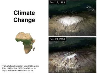
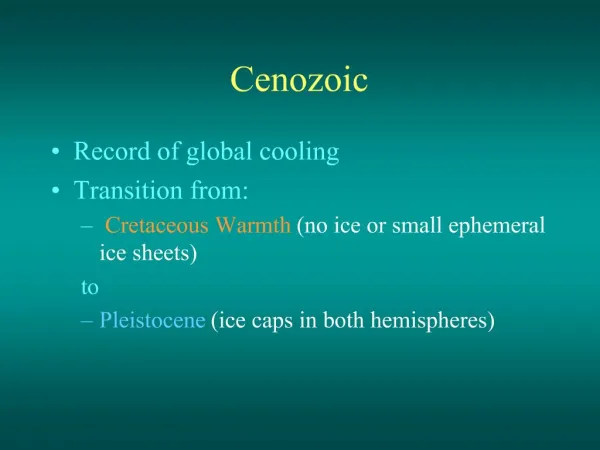
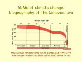
Lecture 4 Cenozoic Climate Change. We are in the midst of an interglacial time. Still, we know the glaciers will come back. Let’s recall how the Earth’s climate changed during the Cenozoic. Cenozoic Cooling.

Lecture 4 Cenozoic Climate Change
E N D
Presentation Transcript
Lecture 4 Cenozoic Climate Change We are in the midst of an interglacial time. Still, we know the glaciers will come back. Let’s recall how the Earth’s climate changed during the Cenozoic.
Cenozoic Cooling • During the Cenozoic, temperatures decreased as moving continents diverted warming currents • During the Cenozoic the poles became much cooler than the equator
Atmospheric circulation By 30o of movement away from the equator, winds are turned by Coriolis and aligned with equator. The Breaks separate flow into 6 cells Polar Cell Ferrell Cell westerlies Hadley Cell trades trades westerlies Explain Coriolis
Winds push currents Surface Currents (Influence Climate) NH winds turn to right, Currents caused by winds East pushed flow near 50 degrees Gyre CW West pushed flow near equator West pushed flow near equator Gyre CCW East pushed flow near 50 degrees WESTERN BOUNDARY CURRENTS MOVE WARM WATER POLEWARD Note Warm Currents not past S 60o Latitudes
Western Boundary Currents • Winds cause water to pile up along the western subtropical sides of major oceans. • Generate fast-flowing currentsthat redistribute warm tropical waters toward the poles. • Gulf Stream, Kuroshio, Brazil currents are “West Side” marine rivers, relatively narrow (less than 100 km across) but deep water masses. • Flow at speeds of 100 to 200 km/day for thousands of kilometers, from equator to high latitudes
Eastern Boundary Current • Eastern boundary currents (Canary, California, Peru) complete the eastern leg of each gyre • Wider, carry less water, and move more slowly. • The Canary current, nearly 1,000 km (625 miles) wide but very shallow • 1/3 water of Gulf Stream and travels at 30 km/day • 2/3 continues as cold deep salty current
WIND North Atlantic Deep Water (NADW) down here
Changes in the positions of the continents greatly influence average current flow WallyBroecker Thermohaline Conveyor
Antarctic Circumpolar Current Paleocene to Mid-Eocene WARM Currents from Tropics Land in polar latitudes but still warm due Western Boundary Currents
Early Eocene Warm Green River Formation Oil Shales
Green River Formation, Wyoming Tropical Plants and Tropical Fish to High Latitudes
Antarctic Circumpolar Current 3. Mid-Late Eocene Sudden Cooling 45 mya Warm current can’t reach Antarctic shores 2. 4. Longest continuous Ice Sheets Start in Oligocene 5. Worldwide spread of Grasses Tolerate cooler and drier climate Grass Herbivores evolve. 1. Australia pulls away
Late Eocene Continents moved - new currents 60oS lat. Silicate weathering a CO2 sink Begin Tibet uplift Antarctica 40 mya Mid Eocene Tibet raises 38 mya due subduction & volcanics, silica weathering increases, CO2 sink
Silicate Weathering as a CO2 Sink • “Another carbon sink is the weathering of mountains and other rock formations formed by plate tectonics, mainly silicate weathering. Carbon dioxide isconsumed from silicate weathering as seen in this equation: …” • CaSiO3+ 2CO2 + 2H2O => CaCO3 + SiO2 + CO2 + 2H2O quoted here: Wollastonite forms when carbonate rocks are subjected to high temperature and pressure in the presence of silica bearing solutions
Early Pliocene Central and South America not connected. Atlantic and Pacific same salinity Gulf Stream 5.5 mya Land in polar latitudes but Arctic still warm due Gulf Stream
Late Pliocene - Gulf stream Saltier 1. 3.5 mya Subduction, Volcanic Arc, Isthmus of Panama closed, North Atlantic isol., higher salinity, dense cool water sinks before it reaches Arctic, polar sea freezes Sudden Cold & Dry Late Pliocene 2. Caused Formation of the modern Gulf Stream Current in the Atlantic 3. Dramatic cooling, dry in Mediterranean dries out thick evaporites
The cause of the Panama land was a Volcanic Island Arc that formed above a subduction zone.
Eocene Mostly warm (56 - 37 million years ago) • Mammals the dominant land animals. • Earliest giant forms of mammals • Many forest plants, freshwater fish, • and insects that were much like those today. Diatryma http://www2.nature.nps.gov/geology//parks/eocene.htm The first horse-like creatures lived in Eocene forests. They were barely bigger than today's domestic cat. Throughout the Cenozoic Era their size increased; their legs became longer and their feet changed from many-toed to single-hoofed, for faster running. Their teeth changed from browsing to grazing.
Oligocene( cooling 37-23 million years ago) • The climate became cooler and drier. • More temperate forests, soft grasses • Late Oligocene, savannas (grasslands & woodlands) • Some mammals become grazers. • Modern groups (dogs, cats, horses, pigs, camels, and rodents) rose to new prominence. http://www.prehistory.com/bronto.htm http://www2.nature.nps.gov/geology//parks/pliocene.htm BRONTOTHERIUM
Miocene (began 24 million years ago Grasses widespread) • Abundance of mammals peak in Miocene. • Forests and savannas persisted in some parts of North America; • treeless plains expanded where cool, dry conditions prevailed. • Many mammals adapted for prairie; grazers, runners, and burrowers. • Large and small carnivores evolved to prey on these plains-dwellers. • Great intercontinental migrations occurred throughout the Miocene • Animals entering and leaving North America. Silica Grasses! High-crown teeth
During the Late Tertiary, temperatures cooled further. Colder air cannot hold as much water, and mid-latitude climates became drier. Trees need great amounts of water, and cannot survive decades of drought. Grasses, on the other hand, can tolerate long periods of drought, and some grasses have a photosynthetic pathway that conserves water, the C4 pathway. Grasslands replaced many forests. Trees retreated to wetter areas, such as the floodplains of rivers. Larger herbivores with taller unrooted teeth evolved to eat silica imbedded grasses. Grasses prevent gully erosion, Bloom p 51r p2
Cenozoic Orogenic activity concentrated in two areas • Alpine-Himalayan belt deformation began in the Mesozoic and remains geologically active. Isolation of Tethys to form the modern Mediterranean Sea • circum-Pacific belt deformation occurred throughout the Cenozoic • Subduction of the Farallon – Pacific MOR
Cenozoic Cooling Southern Ocean forms Panama Forms After Figure 4-1 of Bloom Glaciers over North!
PT + Milankovitch Cycles Furthest away in NH Summer - cool summer Closest in Winter Warm Wet Winter The energy of solar radiation drops off as the square of the distance. Further away = Not as hot => cool summer, warm snowy winter => glaciers grow Cycles every 100,000 years
Present tilt 23.5 degrees High latitude getting more sunlight in winter Warm Wet Winter, abundant snow Cool Summer Snow doesn’t melt GLACIAL High latitude getting less sunlight in summer High latitude getting less sunlight in winter Too cold for much precipitation Cold Dry Winter, little snowfall Hot Summer, winter snow melts INTERGLACIAL High latitude getting more sunlight in summer Snow all melts 41,000 years
How Oxygen’s stable isotopes can measure past temperatures Water molecules containing an oxygen of the lighter 16O isotope are more likely to evaporate from the surface of the ocean and can be frozen into continental ice sheets. This causes the oceans to become enriched in the 18O isotope left behind. This means that glacial times can be recognized from fossil shells containing oxygen from seawater.
The Late Tertiary and Quaternary oxygen isotope record measured in marine fossil shells Evap. water and CO2 during glacial time removes 16O to glacier ice leaving 18O in oceans for CaCO3 shell cf Figure 4.7 of Bloom
Foraminifera tests - Ice Age Wisconsinan Illinoian > 30 pulses in 4 or so major groups Kansan Nebraskan Evap. water and CO2 during glacial removes 16O to glacier ice leaving 18O in oceans for CaCO3 shell warm cold Also spiral direction & diversity dep T
Ice Sheet 20 kya then temporary warming Scoured 30 M below sea-level
Max Glacier Distribution 20,000 ya Maximum glaciation occurs at coincidence of astronomical cycles if land in polar latitudes
Global Temperatures Cycle, largest 100,000 Year (orbit eccentricity) NOW PAST Notice Interglacials get much warmer Smaller signals about 25K and 41K Wisconsinan Interglacials get really WARM and vary in duration
Effects of Glaciation • Change Climate –increase precipitation locally - pluvial lakes • Depress continents & lateral rebound • Drop sea-level:alter coastlines • Form continent-wide Dams • Divert streams – Ohio and Missouri rivers
Air bubbles trapped in glacial ice reveal the composition of the Pleistocene to Recent atmosphere. Uppermost warm in picture is the current interglacial, the Holocene
Cold pulse from about 1300 to 1850 AD (The so-called “Little Ice Age”)Climate has been warming since then. Discussion: Global Warming Worldwide melting, regardless of cause, releases CO2 and H2O and exposes dark land. The atmosphere receives and holds more heat, and temperatures rise. Athabaska Glacier, Columbia Icefield, W. Canada
Summary • 1. Convection currents in the lithosphere move the continents.2. Continent positions deflect ocean convection currents and change ocean basin salinity. These change weather => climate3. We are currently in an interglacial because our spin axis tilt is 23.5 degrees, headed toward 24.5.4. It will get much warmer as the interglacial continues, but then COLDER
Temporary Warming • Interglacial warming releases greenhouse gas – Positive feedback • A warmer system is more energetic • We expect stronger storms, less weather predictability • We expect pole-ward shifts in climates • Eventually the interglacial will end, and then another glacial time will control the surface of earth.
Super Volcano Winters • About 72000 years ago a huge rhyolitic magma on Indonesia erupted. Toba Lake is the large caldera that remains. A worldwide ash fall occurred, three times thicker than any other global Pleistocene ash fall. Some workers think thatSO2 got into the stratosphere, forming H2SO4. Sunlight was blocked around the world, and plants died. • Studies of Mitochondrial DNA in humans reveal that humanity suffered a near extinction event about that time. All humans are descended from a few thousand mothers. http://www.kean.edu/~csmart/Observing/Lectures/Toba/Toba,%20Sumatra,%20Indonesia.htm