Download
1 / 1
10 likes | 304 Views
VHR SAR IMAGES FOR DETECTING SPARSE DAMAGED BUILDINGS IN URBAN AREAS: THE L’AQUILA EARTHQUAKE CASE STUDY. 1 Istituto Nazionale di Geofisica e Vulcanologia 2 Sapienza University of Rome 3 Centre de Recherche Public - Gabriel Lippmann. Christian Bignami 1 , Manuel Di Paolo 2

E N D
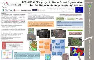
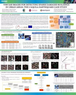
VHR SAR IMAGES FOR DETECTING SPARSE DAMAGED BUILDINGS IN URBAN AREAS: THE L’AQUILA EARTHQUAKE CASE STUDY 1 Istituto Nazionale di Geofisica e Vulcanologia 2 Sapienza University of Rome 3 Centre de Recherche Public - Gabriel Lippmann Christian Bignami1, Manuel Di Paolo2 Nazzareno Pierdicca2, Marco Chini3 Salvatore Stramondo1, Roberta Anniballe2 • 1. INTRODUCTION: THE APHORISM PROJECT • The exploitation of Synthetic Aperture Radar (SAR) at very high resolution (VHR) for the detection of sparse and isolated damage in urban areas, caused by earthquakes, is still a challenging task. Despite the capability to observe small details over the acquired scenario, the interpretation and analysis of VHR SAR images in urban environment is very difficult. Indeed, within urban settlements, the scattering mechanisms are extremely complex and simple change detection analyses or classification procedures can hardly be successfully performed. In this work we analyzed a pair of VHR SAR data captured by the Italian COSMO-SkyMed satellites, on the occasion of the L’Aquila, April 6 2009, earthquake, in Central Italy. Despite about 300 people were killed by the earthquake, the damage occurred in the city were not very widespread: few buildings were completely collapsed, and many others were heavily/partially damaged, resulting in a quite sparse damage distribution. . The analyses were performed with the purpose of understanding the SAR response of damaged structures surrounded by unaffected buildings, attempting to single out the damaged single buildings by a proper classification procedure. • This work is part of a European Commission Funded project, under the Frame Program 7. The project, called APHORISM - Advanced Procedure for Volcanic and Seismic Monitoring, aims at developing and testing new methods to combine Earth Observation satellite data from different sensors, and ground data for seismic and volcanic risk management. The objective is to demonstrate that this two types of data, appropriately processed and integrated, can provide new and/or improved products useful for seismic and volcanic crisis management. One of the methods deals with earthquakes, and it concerns the generation of maps representing the detection and estimate of damage caused by a seism. The method is named APE – A Priori information for Earthquake damage mapping. The use of satellite data to investigate earthquake damages is not an innovative issue. Indeed, a wide literature and projects have addressed and focused such issue, but usually the proposed approaches are only based on change detection techniques and/or classifications algorithms. The novelty of APhoRISM-APE relies on the exploitation of a-priori information derived by: • InSAR time series to measure surface movements • shakemaps obtained from seismological data • structural vulnerability information. Focus of the this poster Likelihood Index Damage Map This a-priori information is then integrated with change detection map from earth observation satellite sensors (either Optical or Synthetic Aperture Radar) to improve accuracy and to limit false alarms. http://www.aphorism-project.eu/ 2. L’Aquila Earthquake: data availability SAR Spotlight-2 Dataset: COSMO- SkyMed Optical Dataset: QuickBird Pre-event Pre-event Post-event Post-event SAR Stripmap Dataset: COSMO- SkyMed A layer of polygons reporting the macro-seismic survey of damage in L’Aquila is used to identify the collapsed and heavily damaged buildings. The macro-seismic survey is based on the European Macroseismic Scale 1998 (EMS98). Pre-event We expect that grade 4 and 5 only can significantly affect the SAR backscattered signals and thus be recognizable Post-event 3. SAR IMAGES ANALYSIS Complex geometry of changes Layover effect from gable roofs as well as double bouncing mechanism can be observed Displacements in the SAR images depend on looking angle and on building height Problems in superimposing SAR data at small looking angle to other data as cartography, NDVI map and building footprint. Comparison between coherence computed within a Region Of Interest – ROI, i.e., the layover or double bounce return area, and conventional approach computing coherence within a square moving window (averaged within the ROI) Building footprint Building position in the SAR image taken by COSMO- SkyMed with an observation angle of 19.07 degrees Totally collapsed Pre-seismic co-seismic coherence scatterplot Despite of problems in sloped terrains, SAR data acquired at smaller observation angles exhibit higher contrast and better sensitivity to change SAR pre-post-post (07/04/2009 – 13/04/2009) Off- nadir angle= 50.57° SAR pre-post-post (22/03/2009 – 05/04/2009) Off- nadir angle= 19.07° Post-event Optical Pre-event Optical Pre-seismic co-seismic coherence ratio Partially collapsed SAR pre-post-post Off- nadir angle= 19.07° SAR pre-post-post Off- nadir angle= 50.57° QuickBird Post-event (09/04/2009) Confusion Matrix from SAR Spotlight. We applied the preliminary procedure and compared changed objected with ground truth. 4. Feasibility study: preliminary procedure and assessment Methodology Flow Chart Feasibility study performed on QuickBird & COSMO-SkyMed SPOTLIGHT @50.57 incidence angle Pre-event SAR image Pre-event SAR image • Methodologies • Optical data: damage visual detection by comparing pre- and post- event images • SAR data: classification approach based on a Decision Tree Algorithm (DTA) Co-registration and radiometric calibration Features extraction Confusion Matrix from Optical data (buildings). By photointerpretation we checked if damaged building s according to ground survey appear changed in the image (no way to evaluate omission errors) DTA NDVI Masking Ground Survey Segmentation Comparison between damage map and ground survey Implemented DTA Damage Map