Problem with GIS Data
Dealing with various related files makes finding and sharing GIS data difficult. Implementing containers, standards, and protocols is crucial for maintaining data quality. Sharing tools and common formats can simplify the process. Geodatabases offer a comprehensive solution but have advantages and disadvantages. Understanding file geodatabases and their components is essential for effective data management.

Problem with GIS Data
E N D
Presentation Transcript
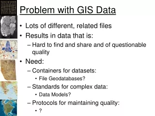
Problem with GIS Data • Lots of different, related files • Results in data that is: • Hard to find and share and of questionable quality • Need: • Containers for datasets: • File Geodatabases? • Standards for complex data: • Data Models? • Protocols for maintaining quality: • ?
Data Complexity • Shapefile: • shp: spatial data • dbf: attributes • shx: index • xml: metadata • prj: SRS • Would be nice if this was all in one file
Sharing Tools • Won’t it be great if we could use tools like model builder to work on the city of Arcata, then use the same tools to work on the city of Eureka, etc. • Need a common format for all the spatial data • Roads, rail lines, parks, water mains, parcels, hydrants, zoning areas, etc
Geodatabases • Definition for a complex set of data • Stored in a Geodatabase • Easily shared Data Model in a “Can”
ESRI Approach • Create their own database structure within a database • Add user’s data into the Esri structure • Personal File Geodatabase • MS-Access • Not supported in the future • Relational Databases • Supported through Arc Spatial Database Engine (ArcSDE) • File Geodatabases
File Geodatabase • Advantages: • Easy to share complex vector datasets • Disadvantages: • Internal structure is hidden • Basically, only supported by Esri products • Raster databases can be huge • Note: • Geodatabases used to be the only way to fix topology problems, now they can be fixed with shapefiles as well
File Geodatabase • Folder with “.gdb” extension! • Additional data types & capabilities: • Relationships • Topology Rules • Feature Dataset • Raster Catalog & Mosaic • Networks • The default for data created from the tool box
New Terminology • Feature Dataset • Set of vector data (points, polylines, polygons) • Common Spatial Reference • Raster Dataset (not recommended) • Set of rasters • Common Spatial Reference • Dataset is like a folder • Name should include Spatial Reference • WGS84_UTM_10_North
Feature Class • Data for one layer of vector data • Points, Polyline, or Polygon • Has spatial data, attributes, metadata • Effectively, a shapefile
File Geodatabase Structure • Disk • Folders… • Geodatabase.mdb • FeatureSet • FeatureClass • Relationships • Tables • Etc.
Data Color-coding yellow coverage green shapefile gray geodatabase
References • Arctur, D. and Zeiler, M., 2004, Designing Geodatabases, ESRI Press • Lowe, J.W., 2003. Flexible data models strut the runway. Geospatial Solutions, 13(2): 44-47. • Maidment, D.R., 2002. Arc Hydro: GIS for Water Resources, ESRI Press, 203 pp. w/CD. • Li, X. and M.E. Hodgson, 2004. Vector-field data model and operations. GISci. Rem. Sens., 41(1): 1-24. • Wright, D., Blongewicz, M., Halpin, P., and Breman, J., Arc Marine: GIS for a Blue Planet, Redlands: ESRI Press, 2007. • In Digital Earth or dusk.geo.orst.edu/djl/arcgis/book.html