Download
1 / 3
30 likes | 166 Views
This GPS Pocket Guide provides essential information for fire management professionals using the Garmin GPSMAP 76S. It covers the setup page for customizing display options, datum settings, and waypoint naming conventions in line with NWCG GPS standards. The guide also discusses how to navigate the GPS features including map setup, electronic compass calibration, track log collection, and waypoint management. With clear instructions and diagrams, it serves as a vital reference for effective navigation and execution of fire management operations in the field.

E N D
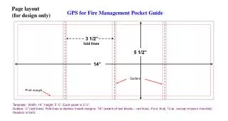
Page layout (for design only) GPS for Fire Management Pocket Guide 3 1/2” fold lines 5 1/2” 14” Gutters Print margin Template: Width: 14”; height: 5 ½”. Each panel is 3 ½”.Gutters: ¼” (red lines). Fold lines in dashes. Inside margins: 1/4” (extent of text blocks – red lines). Font: Arial, 10 pt. (except mission checklist). Headers in bold.
Receiver Operation Datum Waypoint Naming Convention Setup Page GPS for Fire Management FieldReference for the Garmin GPSMAP 76S Use Setup page to customize the way page information is displayed. Go to Location tab to set correct datum and coordinate system (shown is NWCG GPS standard). AS Accident Site MP Milepost BR Bridge MV Medivac Site CA Camp OP Observation Point DB Division Break PR Protected Resource DP Drop Point RH Rehab Site*** DL Dozer Line RJ Road Junction FL Fire Line* RS Radio Site FO Fire Origin SA Staging Area GT Gate SC Stream Crossing HA Hazard** SF Spot Fire HB Helibase ST Structure HS Helispot SZ Safety Zone IC ICP WS Water Source IR Infrared Hotspot *B – Blasted, D – Dozer, H – Hand, W – Wet **M – Mine Shaft, S – Snag, W – Well ***F – Fence, R – Road, W – Water Example: “DBXY” = X – Y Division Break • When there is a change in datum, coordinate values change for all points on the ground. • If using GPS receiver with a map, set receiver datum to match map datum. • If using position or waypoint coordinates from other sources (including GIS), match receiver datum to same datum coordinates were derived in prior to inputting into GPS receiver. Button Layout Map Page Download MapSource maps for greater detail. Press Menu button once to open Map Setup. Set map display preferences as desired. Use Map to visually monitor track log collection. Download a new almanac if GPS receiver is new, has been moved more than 300 miles while turned off, or has not been used within the last 30 days. Turn receiver on and place in location with clear view of sky. Allow up to 15 minutes for a new almanac to download after receiver acquires first satellite signal. The almanac is automatically updated whenever the receiver is in use. Electronic Compass Page Press Menu button once to open Compass Setup menu. Select Calibrate Compass to calibrate the electronic compass (do regularly to maintain accuracy). Receiver Setup Download Almanac Lamp: turn receiver on; adjust backlight/contrast.NAV: go to navigation page; man overboard.ZOOM: map page zoom.PAGE: advance to next page. Turn compass on/off. MENU: once for active page menu; twice to access Main Menu.ENTER: selects option; creates waypointQUIT: exit menu; go to previous page. Main Menu Use Main Menu, Setup, Location to select True, From any page, press Menu button twice.To set up receiver, toggle to Setup, press Enter button once. Proceed through setup pages and change settings as needed.Monitor power and memory from Main Menu. Magnetic, Grid or User for north compass heading. When compass is turned on, a “N” symbol appears in the lower left of the page. Press and hold Page button to turn compass on or off. Caution: compass turned on consumes more battery power. GPS Information Page Always collect waypoints and tracks in either 3D GPS Location or 3D Differential (if WAAS is active – as shown) mode. Note this information on the metadata form. This pocket reference is a supplement to the 2005 GPS for Fire Management Course. Garmin™ is a registered trademark of Garmin International™. Note: when printing guide, delete everything outside of black rectangle prior to printing (keep black rectangle). Front Side
Create New Waypoint Create Averaged Position Waypoint Mission Checklist Area Calculation Collect Track Log Track Log Setup To start collecting a track log, set Recording to Stop When Full. Press Enter button to select. Do not select Wrap When Full. From Main Menu, select Track Logs. Press Menu button to open Track Log Menu. Download and archive active log (if needed). Press and hold Enter button to create a new waypoint. Do not edit date/time field (this information is needed for GIS). Select Ok and press Enter button to save waypoint. Or press Menu button once to access waypoint options menu. • The NWCG GPS standard is datum NAD83(same as WGS84) and lat/longcoordinatesystem in degrees, minutes and seconds. • Briefing • Plan mission to achieve the objectives. • Are mission logistics defined to execute and complete the mission? • Delivered GPS data or product format is understood.Equipment • Select appropriate GPS receiver for the mission. • Use an external antenna whenever possible. • Adequate batteries or power source. • Paper map and compass. • Notebook and pencils. • GPS metadata form. • Prepare GPS receiver • Set datum and coordinate system to NWCG (see above) or incident standard. • Update receiver almanac for the local area. • Download and delete old waypoints, active log and saved tracks if not needed to clear memory. • Set up Track Log collection interval based on method of travel and speed, and size of area to be mapped. • Check wires, connections and power source. • Verify all GPS settings are correct prior to mission. • Aerial mapping mission • Brief pilot on mission prior to takeoff. • Ensure reliable external antenna connection. • Carry spare GPS receiver and extra batteries as backup. To pause logging, set Recording to Off. When mapping mission is complete, either turn GPS receiver off or save track log (saving log provides area calculation). Tracks page displays percentage of memory used. Clear Active Log and saved Tracks to free up memory. Select Setup Track Log. Press Enter button once. Monitor memory usage to ensure adequate free memory to complete the mission. Record Mode set to OFF for setup. Set Interval to Time. Set Interval Value based on method of travel during data collection, and size of area to be mapped. A total of 10,000 track points are available. Mark waypoint. Name waypoint if needed. Do not edit date/time field. Press Menu button once to open Waypoint Options menu. After collecting a perimeter track log, save active log. Up to 10 tracks may be saved. Open a saved Track Log from the Tracks page. Area format can be Select Average Location and press Enter button once. Averaging begins automatically. Approximate log times (start with empty Track Log): One second interval: 2.7 hours total log time. Three second interval: 8.3 hours total log time. Five second interval: 13.8 hours total log time. Suggested logging rates (based on speed of travel): Helicopter: 1 - 3 second log interval. Walking: 5 - 10 second log interval. Vehicle: 3 - 7 second log interval.Logging interval may be changed during mission. changed. Select “ac” for acres (as shown).Caution: when mapping any perimeter, do not close polygon at the same point the track log was started. Doing so may create overlapping track points, which may cause an area miscalculation, as well as data problems in GIS. Note position count for each waypoint on metadata form. Select and press Save when done. Positions will be averaged into a single waypoint. Back Side