Download
1 / 4
40 likes | 57 Views
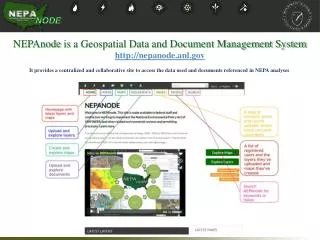
We at Marvel Geospatial, provide you with an ultimate Geospatial Solution with our accurate data mapping and management services. Marvel brings horizontal and vertical integration of Satellite/Aerial Remote Sensing, Positioning Applications, Photogrammetry, GIS Databases and Applications, GIS Web-services and Networking of GIS Databases.Marvel offers expert advice and reliable data for all geospatial needs. Discover whatu2019s possible with Marvel. Give us a call today for a free consultation!

E N D
Marvel Geospatial Solutions PVT LTD Welcome Website : https://www.marvelgeospatial.com/ Contact : +91-40-23239595 Email : info@marvelgeospatial.com
Marvel Geospatial - a solution for accurate data mapping and management. We at Marvel Geospatial, provide you with an ultimate Geospatial Solution with our accurate data mapping and management services. Marvel brings horizontal and vertical integration of Satellite/Aerial Remote Sensing, Positioning Applications, Photogrammetry, GIS Databases and Applications, GIS Web-services and Networking of GIS Databases.Marvel offers expert advice and reliable data for all geospatial needs. Discover what’s possible with Marvel. Give us a call today for a free consultation!
Our Services • GIS Services • UAV Services • Photogrammetry Services • BIM Services • best Topographical Survey company, • Scan to BIM Modelling services, • Mapping services Contact Us For any Service Given Above, we are a team of expert and offers these services in Hyderabad.