Download
1 / 2
20 likes | 147 Views
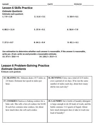
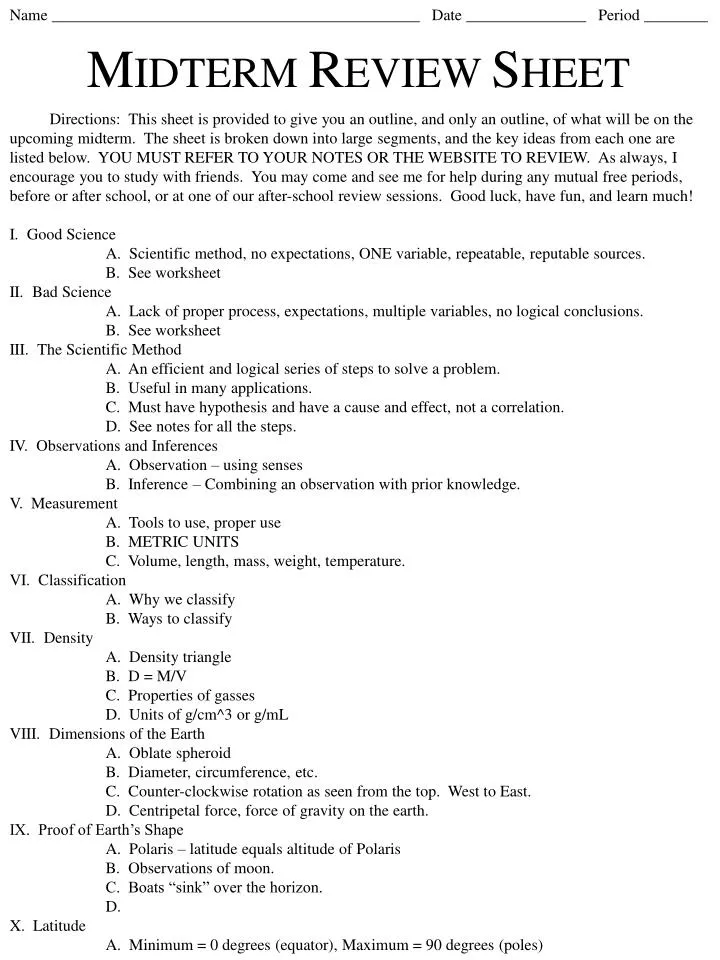
Name ______________________________________________ Date _______________ Period ________. M IDTERM R EVIEW S HEET.

E N D
Name ______________________________________________ Date _______________ Period ________ MIDTERM REVIEW SHEET Directions: This sheet is provided to give you an outline, and only an outline, of what will be on the upcoming midterm. The sheet is broken down into large segments, and the key ideas from each one are listed below. YOU MUST REFER TO YOUR NOTES OR THE WEBSITE TO REVIEW. As always, I encourage you to study with friends. You may come and see me for help during any mutual free periods, before or after school, or at one of our after-school review sessions. Good luck, have fun, and learn much! I. Good Science A. Scientific method, no expectations, ONE variable, repeatable, reputable sources. B. See worksheet II. Bad Science A. Lack of proper process, expectations, multiple variables, no logical conclusions. B. See worksheet III. The Scientific Method A. An efficient and logical series of steps to solve a problem. B. Useful in many applications. C. Must have hypothesis and have a cause and effect, not a correlation. D. See notes for all the steps. IV. Observations and Inferences A. Observation – using senses B. Inference – Combining an observation with prior knowledge. V. Measurement A. Tools to use, proper use B. METRIC UNITS C. Volume, length, mass, weight, temperature. VI. Classification A. Why we classify B. Ways to classify VII. Density A. Density triangle B. D = M/V C. Properties of gasses D. Units of g/cm^3 or g/mL VIII. Dimensions of the Earth A. Oblate spheroid B. Diameter, circumference, etc. C. Counter-clockwise rotation as seen from the top. West to East. D. Centripetal force, force of gravity on the earth. IX. Proof of Earth’s Shape A. Polaris – latitude equals altitude of Polaris B. Observations of moon. C. Boats “sink” over the horizon. D. X. Latitude A. Minimum = 0 degrees (equator), Maximum = 90 degrees (poles)
B. Lines go east and west, like a ladder. C. Can tell you position of Polaris. D. Comes FIRST. E. Divided into degrees, minutes (60) and seconds (60). XI. Longitude A. Minimum = 0 degrees (prime meridian), Maximum = 180 degrees (int’l date line). B. Lines run north and south, they’re long. C. Is listed LAST. E. Divided into degrees, minutes (60) and seconds (60). F. Know how to find latitude and longitude on a map, and also give the coordinates of a point. You know this! XII. Time zones A. 15 degrees wide B. 1 hour wide C. Know that the Earth spins west to east! XIII. Topographic maps A. Contour lines B. Contour interval C. Isolines, depression contour lines D. Index contour line E. Know how to read a contour map! F. Contour lines bend UPSTREAM! G. Contour map profiles – know how to make them. H. How to find distances on a map using the scale. XIV. GRADIENT A. Formula on the front of the reference tables! B. Change in field value divided by distance. C. Usually in meters/kilometer. D. Know how to use the formula. E. Can use it with elevation, temperature, etc. XV. Weathering A. Chemical weathering B. Physical weathering C. Know where each type happens D. Rates (temperature, rainfall, etc.) E. More surface area, more weathering. F. XVI. Erosion/Deposition A. Movement of eroded particles. B. Effects of density, mass, roundness, size. C. Stream velocity chart in ESRT. D. Sorted (streams) vs. unsorted (glaciers, landslide) sediments E. Stream flows and deposition. F. Watersheds. XVII. Landscapes A. Glacial landscapes – U-shaped, etc. B. Different rocks = different landscape C. Know maps to use on ESRT D. Glacial shaping of landscapes MY REVIEW SESSION TIME AND DATE: _____________________________________