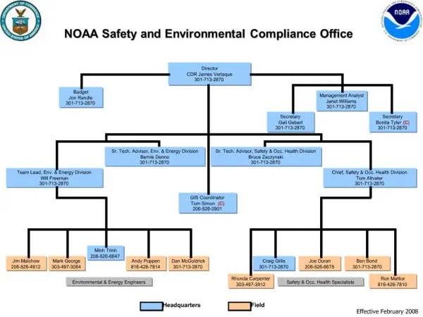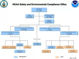
The NOAA Environmental Software Infrastructure and Interoperability Group
280 likes | 492 Views
The NOAA Environmental Software Infrastructure and Interoperability Group. Cecelia DeLuca NESII Team IS-ENES General Assembly June 12, 2014. Outline. Overview Modeling Infrastructure Earth System Modeling Framework (ESMF) and Grid Remapping ESMF Python (ESMPy)

The NOAA Environmental Software Infrastructure and Interoperability Group
E N D
Presentation Transcript
The NOAA Environmental Software Infrastructure andInteroperability Group Cecelia DeLuca NESII Team IS-ENES General Assembly June 12, 2014
Outline • Overview • Modeling Infrastructure • Earth System Modeling Framework (ESMF) and Grid Remapping • ESMF Python (ESMPy) • National Unified Operational Prediction Capability (NUOPC) Layer and the Earth System Prediction Suite • ESMF Web Services • Metadata and Data Infrastructure • Earth System Documentation (ES-DOC) Questionnaire and Downscaling Metadata Project • CoG Collaboration Environment • OpenClimateGIS
The Vision • Develop interoperable modeling components that can connect in multiple waysImprove predictions and support research • Build advanced utilities that many models can useEnable research, promote cost efficiency • Enable models to be self-describingIncrease understanding and defensibility of outputs • Create workflows that automate the modeling process from beginning to endImprove productivity • Build workspaces that encourage collaborative, distributed development of models and data analysisLeverage distributed expertise
Key Strategies • Commitment to standards (data, metadata, component interfaces, services) to maximize interoperability • Community-driven development and community ownership • Formal governance processes in which customers set priorities • Frequent public design reviews and demonstrations • Expertise shared among partners • Openness of project metrics, code and information • Commitment to a globally distributed and diverse development and customer base
The Earth System Modeling Framework The Earth System Modeling Framework (ESMF) was initiated in 2002 as a multi-agency response to calls for common modeling infrastructure. ESMF delivered: • Standard interfaces for model components • High performance libraries and tools for time management, data communications, metadata and I/O, and parallel grid remapping Metrics: ~5500 downloads ~3000 individuals on info mailing list ~40 platform/compilers regression tested ~6400 regression tests ~830,000 SLOC http://www.earthsystemmodeling.org
Standard Interfaces All ESMF components have the same three standard methods: Initialize Run Finalize Each standard method has the same simple interface: • Steps to adopting ESMF • Divide the application into components (without ESMF) • Copy or reference component input and output data into ESMF data structures • Register components with ESMF • Set up ESMF couplers for data exchange call ESMF_GridCompRun (myComp, importState, exportState, clock, …) Where: myComp points to the component importState is a structure containing input fields exportState is a structure containing output fields clock contains timestepping information • Interfaces are wrappers and can often be set up in a non-intrusive way
ESMF Grid Remapping • Uniquely fast, reliable, and general – interpolation weights computed in parallel in 3D space • Supported grids: • Logically rectangular and unstructured grids • Global and regional grids • 2D and 3D grids • Supported interpolation methods: • Nearest neighbor, higher order patch recovery, bilinear and 1st order conservative methods • Options for straight or great circle lines, masking, and a variety of pole treatments • Multiple ways to call ESMF grid remapping: • Generate and apply weights using the ESMF API, within a model • Generate and apply weights using ESMPy, through a Python interface • Generate weights from grid files using ESMF_RegridWeightGen, a command-line utility Somesupportedgrids … HOMME Cubed Sphere Grid with Pentagons Courtesy Mark Taylor of Sandia Regional Grid FIM Unstructured Grid
ESMPy: ESMF Python Interface to Grid Remapping • Enables ESMF regridding to be used with very little effort, in an object oriented way: • Regridding applied as a callable Python object • Numpy array access to distributed data • Some users report computation times reduced from hours to minutes • Enables ESMF regridding to be used in other scientific packages with Python-based workflows – current users include: • UV-CDAT (PCMDI) – Ultrascale Visualization Climate Data Analysis Tools • PyFerret (NOAA) – Python based interactive visualization and analysis environment • Community Surface Dynamics Modeling System (CSDMS) – tools for hydrological and other surface modeling processes • Plus many individuals … https://www.earthsystemcog.org/projects/esmpy/
National Unified Operational PredictionCapability (NUOPC) • ESMF allows for many levels of components, types of components, and types of connections • In order to achieve greater interoperability, usage and content conventions and component templates are needed • A collaboration of NOAA, Navy, Air Force, and their research partners is building a “NUOPC Layer” that constrains how ESMF is used, and introduces metadata and other content standards https://www.earthsystemcog.org/projects/nuopc/
NUOPC Additions to ESMF • The NUOPC Layer adds to ESMF: • A formalism that describes and splits the phases of initialization • A formalism for checking and reporting whether component requirements are satisfied during the run sequence • Code templates for drivers, models, mediators (couplers) and connectors, and example application showing a variety of model interactions (e.g. explicit, semi-implicit, implicit coupling) • Compliance checkers
The Earth System Prediction Suite • The Earth System Prediction Suite (ESPS) is a collection of major U.S. and climate modeling codes that use ESMF with the NUOPC conventions. • The ESPS makes clear which codes are available as ESMF components and modeling systems. https://www.earthsystemcog.org/projects/esps/
Model Codes in the ESPS Currently, components in the ESPS can be of the following types:coupled system, atmosphere, ocean, wave, sea ice Target codes include: • The Community Earth System Model (CESM) • The NOAA Environmental Modeling System (NEMS) and Climate Forecast System version 3 (CFSv3) • The MOM5 and HYCOM oceans • The Navy Global Environmental Model (NavGEM)-HYCOM-CICE coupled system • The Navy Coupled Ocean Atmosphere Mesoscale Prediction System (COAMPS) and COAMPS Tropical Cyclone (COAMPS-TC) • NASA GEOS-5 • NASA ModelE
ESPS Code Status Spanning major climate, weather, and ocean codes, ESPS is the most directresponse to calls for common modeling infrastructure yet assembled
ESMF Web Services andClimate Impacts Modeling • The ESMF distribution allow any networked ESMF component to be available as a web service. • Coupling using web services offers a new perspective on climate impacts modeling. • Instead of what impacts are “put in” the climate model … • How do we create a distributed network of models that links climate to local and regional processes while preserving native infrastructure and specialized information delivery systems? • Partners include NESII, University of South Carolina, University of Michigan.
Client Atmosphere-Hydrology Prototype Web Browser • Hydrologic model: Soil and Water Assessment Tool (SWAT) runs “in the cloud” on Amazon Web Services Virtual Server, with a native (OpenMI) interface • Atmosphere Model: Community Atmosphere Model (CAM) or Weather Research and Forecast Model (WRF) runs on a supercomputer, with an ESMF interface • Wrappers for models provide OpenMI RESTful service interfaces • Driver (Web Application) uses OpenMI/HTTP interface to timestep through models PersonalComputer Apache HTTP Server ESMF OpenMI Service High Performance Computer ESMF Web Services OpenMI Svc ESMF CAM Component SWAT • Access to the atmosphere model across the network is through ESMF Web Services • Atmosphere model output data is streamed via ESMF Web Services Amazon Web Services EC2 Virtual Windows Svr
Prototype Status • Technical proof-of-concept is complete, not scientifically validated • Currently refining a GUI capability which allows for specification of fields exchanged https://www.earthsystemcog.org/projects/hydroclimatemodeling/
ES-DOC Earth System Documentation (ES-DOC) is an international effort to develop tools to describe Earth system models in order to better understand and utilize model data. The tools are based on the Common Information Model (CIM) standard. CMIP5 (the Coupled Modeling Intercomparison Project) is the international modeling effort underlying the IPCC assessments. Metadata describing the models used can be viewed at the link below. https://www.earthsystemcog.org/projects/es-doc-models/
ES-DOC Questionnaire • Motivated by the need to collect model information for intercomparison projects • Collaboration with E.U. IS-ENES partners and National Climate Predictions and Projections (NCPP) platform – a NOAA project focused on making local and regional climate information more usable in applications • Developed a flexible utility based on the Common Information Model (CIM) developed by the E.U. Metafor project • Generates customizable CIM-based questionnaires on the fly Screenshot of asample questionnaire https://www.earthsystemcog.org/projects/es-doc-models/questionnaire_description
Downscaling Metadata • Collaboration led by NCPP, with E.U. IS-ENES partners, the COST-VALUE project, ES-DOC and others – NESII is a technical partner • Participants are creating controlled vocabularies and defining modifications to the CIM that support the description of statistical and dynamical downscaling methods • The leads intend to combine this effort with the CIM Questionnaire to create custom questionnaires that can collect downscaling information https://www.earthsystemcog.org/projects/downscalingmetadata/
Overview of CoG • Some of the 70+ projects currently hosted on CoG include: • NOAA’s High Impact Weather Prediction Project (HIWPP) • Atmospheric Dynamical Core Model Intercomparison Project (DCMIP) • Reanalysis Data for CMIP5 (Ana4MIPs) • Observational Data for CMIP5 (Obs4MIPs) • National Unified Operational Prediction Capability (NUOPC) • National Climate Predictions and Projections Platform (NCPP) • Earth System Documentation (ES-DOC) • Earth System Prediction Capability (ESPC) • CoG is a collaboration environment and hub to connect projects in the Earth sciences. • It hosts and links into networks software development projects, model intercomparison projects (MIPS), events, and workshops. • It includes a configurable search to data on ANY ESGF data node. • It provides projects with a wiki and customizable navigation to wiki content. • It contains an ontology for the description and management of projects and provides a consolidated look at this content across a project’s network. • It contains a file server for documents and images. • It provides services for Earth system model metadata collection and display (through ES-DOC tools)
ESGF-CoG Integration • The Earth System Grid Federation is software for the management and analysis of Earth science data on a global scale. • CoG is a collaboration environment and hub to connect projects in the Earth sciences. • CoG will provide a superior interface to ESGF users and data managers in terms of: • Overall usability • Content management • Model intercomparison project support • Multi-project support • Online collaboration tools Reference: 3rd Annual Earth System Grid Federation and Ultrascale Visualization Climate Data Analysis Tools Face-to-Face Meeting Report December (http://aims-group.github.io/pdf/ESGF_UV-CDAT_Meeting_Report_March2014.pdf)
OpenClimateGIS • OpenClimateGIS (OCGIS) is a Python-based, open source software library enabling dynamic access to and manipulation of climate data • Its goal is to overcome barriers of usability of climate projections in adaptation planning and resource management • Translate out of climate data formats to GIS-friendly formats • Select geographical regions of interest • Select times/levels of interest • Compute application-relevant indices • Convert to end-user and analysis-ready formats • Provide comprehensive metadata • Developed and used by the NCPP project, the IS-ENES climate4impact project, ClimatePipes, and others http://www.earthsystemcog.org/projects/openclimategis/
Computationand Format Conversion • OpenClimateGIS is designed to accommodate a variety of climate indices and metrics: • Temporally grouped functions → monthly means, annual maximums, durations • String-based functions → ‘diff=tasmax-tasmin’ • Simple transforms → natural logarithm • Multivariate functions → heat indices • A general framework for data conversion allows data to be streamed to multiple formats: currently, CSV, Key-CSV Shapefile (CSV+), GeoJSON, netCDF, ESRI Shapefile, array-based
Subsetting • OpenClimateGIS handles many types of geospatial subsetting: • Points • Arbitrary Polygons • Bounding Boxes • Collections of Points and Polygons • Reads geometries directly from ESRI Shapefiles, point/bounding box sequences, Shapely geometry objects • Temporal subsetting - time ranges or “regions” (i.e. arbitrary month and year combinations) • Level subsetting - lower and upper bounds • Reads and writes many common coordinate reference systems
Dataset Bundling • Bundles or packages are groups of data over which to apply a common set of operations (e.g. processing of ensembles) • OpenClimateGIS consolidates coordinate systems for the datasets and subset geometry(s) and applies selected operations to each
Precipitation Threshold forTampa Bay Watershed Basins • Figure at right generated using Quantum GIS with shapefile output from OpenClimateGIS. • It shows daily precipitation exceedances using a threshold value of 9.62 mm/day for July 1990. • Source data uses the Bias Corrected/Constructed Analogs (BCCA) method to downscale data from the Canadian Center for Climate Modeling Analysis's (CCMA) Coupled Global Climate Model (CGCM).
NESII Collaborators and Customers • NOAA ESRL GSD/PSD, GFDL, NCDC, PMEL, NCEP Environmental Modeling Center • NASA JPL, Goddard Space Flight Center, GISS • DOE PCMDI, Argonne National Laboratory, ORNL, Sandia • DoD NRL Stennis and Monterey, Naval Oceanography, Army ERDC, Air Force Weather Agency • NCAR Community Earth System Model, WRF, MPAS, HAO, Unidata • University of Michigan, Purdue University, University of South Carolina, University of Colorado, Colorado State University, Georgia Institute of Technology • GO-ESSP, CUAHSI, CSDMS, OpenMI, OGC, CCA, METAFOR • Delft Hydraulics, British Atmospheric Data Center, CERFACS, IPSL, Univ. Reading, UK Met Office, DKRZ, MPI • Many more …
Questions? • For more information, links and references, see our group pages:http://esrl.noaa.gov/nesii/https://www.earthsystemcog.org/projects/nesii/