ORA Milestone: VISIT Training
The VISIT teletraining project aims to educate National Weather Service (NWS) forecasters on the use of GOES satellite imagery for winter weather forecasting and nowcasting. Operational since January 2005, the program consists of two 90-minute sessions, covering topics from synoptic to mesoscale applications. This training reinforces NOAA’s priority of Environmental Literacy, Outreach, and Education, equipping forecasters with crucial skills for real-time weather assessment.

ORA Milestone: VISIT Training
E N D
Presentation Transcript
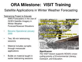
ORA Milestone: VISIT Training Satellite Applications in Winter Weather Forecasting • Teletraining Project to Educate NWS Forecasters in the Use of GOES Satellite Imagery in Winter Weather Forecast/Nowcast Situations • Became Operational January 2005 • Two, 90-min teletraining sessions • Material includes synoptic through mesoscale applications • Builds on material taught in earlier teletraining sessions Significance: The VISIT lesson supports NOAA’s cross-cutting priority of Environmental Literacy, Outreach, and Education.
ASPB 2nd Quarter FY05 Highlights Feature-tracked Winds from AIRS Retrievals: A first-ever demonstration of extracting atmospheric motions from satellite sounder retrieved moisture fields was performed at CIMSS. 400 hPa specific humidity fields were derived using a CIMSS retrieval algorithm applied to Single Field of View (SFOV) Atmospheric Infrared Sounder (AIRS) data from the Aqua satellite. The winds were produced by tracking moisture features from a sequence of three near-polar retrieved humidity field images separated in time by 100 minutes each. A coherent set of vectors was obtained. These very preliminary results from low resolution AIRS retrievals are encouraging in that future instruments with much improved temporal and spatial sampling should yield even better quantities. ??? Impact : ??? Benefit :
ASPB 2nd Quarter FY05 Highlights New AVHRR Reflectance Calibration for Climate Studies • MODIS and HYPERION data utilized • Co-located AVHRR and MODIS views • New calibration produces consistent • AVHRR data from different satellites • Useful for analysis of long-term • time series Time series of AVHRR parameters from near Greenland (green) and over the tropics (blue) from multiple multiple satellites. Note the consistency of the record. The spike in the blue is due to a volcanic eruption. ??? Impact : ??? Benefit :
Other ASPB Highlights Integrated Global Observing Strategy Cryosphere Workshop: The first Integrated Global Observing Strategy (IGOS) Cryosphere Theme Workshop was held March 2-4, 2005 at Kananaskis Village, Alberta. The workshop brought together representatives from research institutions and government agencies to work on the identification of the major issues regarding a common and integrated observational strategy for snow and ice cover, permafrost and seasonally frozen land, glaciers, ice sheets, and ice caps, and solid precipitation. J. Key is the lead on the IGOS Cryosphere Theme and organized the workshop, which was sponsored by the Canadian Space Agency. ??? Impact : ??? Benefit :
Other ASPB Highlights Operational Use of Polar Winds Data by the (U.K.) Met Office: The Met Office (United Kingdom) began using the Moderate Resolution Imaging Spectroradiometer (MODIS) polar winds product in their operational forecast system this week. Five other numerical weather prediction centers currently use the MODIS winds in operational forecast system: the European Centre for Medium-Range Forecasts (ECMWF), the NASA Global Modeling and Assimilation Office (GMAO), the Japan Meteorological Agency (JMA), the Canadian Meteorological Centre (CMC), and the Fleet Numerical Meteorology and Oceanography Center (FNMOC) of the Naval Research Lab. ??? Impact : ??? Benefit :
SCSB 2nd Quarter FY05 Highlights • MSPPS algorithm changes become operational (Feb 05): • New snow water equivalent product • Upgrades: • Total precipitable water (remove across scan biases) • Snow cover (better delineation between snow on ground and rain) • Precipitation rate (expand to colder surface temperatures) • Development of fully integrated, ecosystem model of the Chesapeake Bay watershed and estuary initiated • Participation in the International Ocean Colour Coordinating Group (Margarita Island, Venezuela, Jan 05) • Completed Management and Supervision training at the NWS Training Facility (Kansas City, KA) ??? Impact : ??? Benefit :
RAMMB 2nd Quarter FY05 Highlights Hurricane Wind Field Estimation from GOES Imagery • Historically, GOES imagery is used to estimate the hurricane maximum wind at a single point (Dvorak method) • Through correlation analysis a new method for estimating hurricane wind structure from GOES imagery was developed by RAMMB • Algorithm developed from co-located GOES imagery and aircraft reconnaissance data set • Method will be most useful in regions with no aircraft recon (most of the world except the Atlantic) Impact : ??? Wind field estimates from GOES (left) and aircraft (right) for Hurricane Ivan 13 Sept to 15 Sept 2004 ??? Benefit :