Download
1 / 19
190 likes | 215 Views
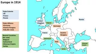
This paper provides an overview of the UK OISG and GIMSE initiatives, focusing on the role of Deployed Field Geographic Support. It includes detailed insights on current support to UK Defence, concepts of OISG and GIMSE employment, and specialized capabilities in geographic intelligence. The study discusses the challenges, development, and implications of these initiatives within the UK defense framework.

E N D
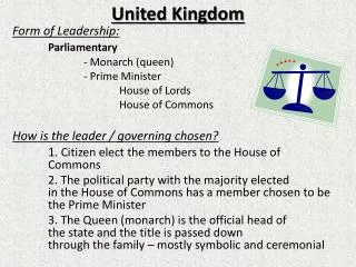
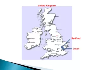
UNITED KINGDOMDeployable Geographic and Imagery Intelligence Convergence Maj J TATE BEng MSc RE(Geo) SI TERA
AIM To provide an overview of the UK OISG and subsequent GIMSE initiatives, focusing on the specific role of Deployed Field Geographic Support
OUTLINE • Introduction • Outline current Deployable Geo Support to UK Defence • Explain concept of employment of OISG • Explain concept of employment of GIMSE • Summary • Questions?
Some Definitions…. • OISG • Operational Intelligence Support Group • GIMSE • Geo/IMINT/MASINT Support Element • Organic Geo Staff • Military Geographic Staff on permanent establishment in component and formation HQs.
Field Deployable Capabilities: Data Management Acquisition & Creation of Data Geo Advice Terrain Analysis Geo Info Presentation (incl Visualisation) Geo Information Dissemination Geo Information Production Specialist Geo Training Geo Systems Sp
Force Structure Example: Example of a Possible Deployed Force Structure: Geo Cell Geo Cell Geo Cell Geo Cell Geo Cell Geo Cell on Peace Establishment Geo Cell Geo Cell on TTW Geo Cell
C O R P S D I V B D E Organic Geo Staff: Land Component Example: HQ ARRC Lt Col + 9 1 (UK) Armd Div Capt + 3 3 (UK) Mech Div Capt + 4 4 Armd Bde Sgt 20 Armd Bde Sgt 1 Mech Bde Sgt 19 Mech Bde Sgt 12 Mech Bde Sgt + LCpl 7 Armd Bde Sgt 16 AA Bde Sgt + LCpl
Geo Cell Geo Cell Geo Cell Geo Cell Geo Cell Force Structure Example: G S G Geo Data Collection & Preparation TERA & Vis Data Man Geo Info Presentation Bulk Geo Info Production Sys Sp Bulk Geo Info Dissemination Spec Trg Geo Cell on Peace Establishment Geo Cell Geo Cell on TTW Geo Cell
All Sources Input G S G Geo Data Collection & Preparation Bde HQ FRONT END Comd Data Man TERA & Vis Organic Geo Sp Cell Geo Info Presentation Bulk Geo Info Production Advice C2 TERA & VIS Sys Sp Bulk Geo Info Dissemination Data Man Spec Trg Info Presentation Functional Relationships: BACKUP! Production
OPERATIONAL INTELLIGENCE SUPPORT GROUP(OISG) The Land OISG capability will be the conduit by which intelligence collection and processing capabilities, not organic to the formation but of direct relevance to a commander’s Area of Intelligence Responsibility (AIR) and Area of Intelligence Interest (AII), can be accessed.
S Close T G2 A Support R Analysis/ DIS TS Capability PJHQ Analysis/ DGIA CM Organic Geo + IMINT DGIA Force Geo (GSG) + IMINT NEC Intelligence Ring main GCHQ Allies How the OISG works.. DGIA GEG GIMSE DGC JARIC ISE Comms Non-DGIA Imagery Elements ISR General Support Analysis/ Dissemination Cmd / Ops/CM SSE HSE Analysis/DB
GIMSE Initiative • Geo/IMINT/MASINT Support Element - GIMSE • Stepping stone towards satisfying OISG requirements • Improved DGIA support to Deployed Forces • Deployed IMINT • Geo/IMINT Convergence • Comms • US MIGS Example
GIMSE Initiative Advice and Sp to Commander
S Close T G2 A Support R Analysis/ DIS TS Capability PJHQ Analysis/ DGIA CM Organic Geo + IMINT DGIA Force Geo (GSG) + IMINT NEC Intelligence Ring main GCHQ Allies How the OISG works.. DGIA GEG GIMSE DGC JARIC ISE Comms Non-DGIA Imagery Elements ISR General Support Analysis/ Dissemination Cmd / Ops/CM SSE HSE Analysis/DB
GIMSE Initiative Challenges • Resources • People • Geo - already committed • IMINT - efficiencies by deploying • Equipment • Staged approach, coord with OISG development • Comms (Exploit PDBS at first) • Releasability of imagery (usually 4 Eyes) • hence focus on OISG Support • Deployed IMINT ownership and ISTAR proliferation • current study on Common Imagery Ground Stations • Money • There is no money!!!! (We have to use what we have)
GIMSE Initiative Development • Imagery Analysts with Geo Engr Gp • trialled on EX ARRCADE GUARD • GSG not necessarily best place • JARIC LO at HQ better solution • next major trial EX JOINT VENTURE 04 • Convergence Study • Equipment Capability • Quick Win with PDBS possible • Keep up with OISG Development • Keep up with Joint Environmental
Summary • OISG will deliver cohesive information directly to the fighting formation. • Many UK Defence stakeholders will need to reconfigure and realign current operational procedures to fully engage OISG concept • DGIA will meet requirements of OISG by committing to GIMSE initiative in order to be well placed for OISG operating capability.
Maj John Tate BEng MSc, RE Senior Instructor Terrain Analysis Royal School of Military Survey Geographic Engineer Group Denison Barracks Hermitage, THATCHAM, Berkshire, RG18 9TP, UK Tel: Civ++ 44 (0) 1635 204238 Internet - tatej@rsms,ac.uk QUESTIONS?