Download
1 / 28
300 likes | 532 Views
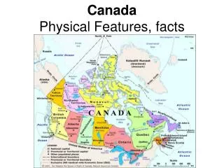
Physical Features of Canada. Great Lakes. Canada is home to many lakes. The Great Lakes form part of the border with the United States. The Great Lakes include 5 large freshwater lakes in central North America. (They are Lakes Huron, Ontario, Michigan, Erie, Superior)

E N D
Great Lakes Canada is home to many lakes. The Great Lakes form part of the border with the United States. The Great Lakes include 5 large freshwater lakes in central North America. (They are Lakes Huron, Ontario, Michigan, Erie, Superior) The Great Lakes serve as the “industrial heartland” of the continent because of all of the factories located there. It is one of the world’s busiest shipping areas and most of Canada’s population lives in this region.
St. Lawrence River The St. Lawrence River connects the Great Lakes with the Atlantic Ocean. In 1959, the U.S. and Canada completed the St. Lawrence Seaway, a series of locks, canals, and dams that allow huge, oceangoing ships to travel from the Atlantic Ocean to the Great Lakes.
Hudson Bay The Hudson Bay is a gulf in east central Canada. It is connected to both the Artic and Atlantic Ocean.
Atlantic Ocean The Atlantic Ocean is the 2nd largest of the earth’s 5 oceans. It is the Most heavily traveled ocean. It Forms the eastern border of Canada. It is also a Major shipping route to Europe & Africa.
Pacific Ocean The Pacific Ocean Largest & deepest of the world’s 5 oceans It Covers 1/3 of the earth’s surface! It is located on the Western border of Canada. • Major shipping route to Asia
Canadian Shield • The Canadian Shield stretches from Great Lakes to Arctic Ocean; covers half of Canada! The Canadian Shield covers a large part of eastern and central Canada. It has ancient rock just below and sometimes sticking out of the soil. The area is known for its thin, rocky soil and rough, rolling landscape. This region has many lakes and rivers and is rich in minerals like gold, diamond, and iron. It is the Horseshoe region around Hudson Bay
Rocky Mountains The Rocky Mountains are Mountains located in Western Canada. It Includes western Alberta and eastern British Columbia Stretch a distance of 2,000 miles! Mining is the biggest industry in the region, followed closely by logging. Major minerals include: iron ore, copper, coal, gold It is Sparsely populated & contain few cities.
Be the Thing… • Your Task: • Choose 1 of the physical features • Fold your paper “hamburger style” to make a desk tent • On the front : Imagine that you are one of the features. Write 3 facts about yourself. • On the back: draw an illustration of the feature • We will walk around and try to guess the features!
My Example… Who Am I? • Brrrrr! I am always so cold!! It’s chilly up here in northern Canada. • I am so tired of everybody always picking on me. Dig, dig, dig all day long. • I wish I had some pretty trees to look at…All that I can see is scraggly trees and flat, rocky land. • It’s so lonely. No one lives near me.