Download
1 / 28
280 likes | 468 Views
Introduction to Remote Sensing of the Environment 4111/5111. Ken Driese Dept. of Botany . Group Activity: Remote Sensing Fundamentals. What is resolution, and is high resolution better than low resolution? Why is the sky more orange at sunset when forest fires are burning?

E N D
Introduction to Remote Sensing of the Environment4111/5111 Ken Driese Dept. of Botany
Group Activity: Remote Sensing Fundamentals • What is resolution, and is high resolution better than low resolution? • Why is the sky more orange at sunset when forest fires are burning? • Why do plants look green? • What is infrared light, and why is it so important in remote sensing? • How does a computer display color images? • Why do trees look different than dirt in a satellite image? • How can you make an elevation map with remote sensing? • Why do lots of satellites orbit over the earth’s poles?
Course Topics • Electromagnetic radiation • Emphasis on satellite remote sensing • Emphasis on land management applications – particularly vegetation mapping and monitoring • Survey of specialized types of remote sensing
Types of Remote Sensing -- Sensors • Photography • Film, Digital, Aerial, Orbiting • Multispectral Imaging • Hyperspectral Imaging • Active Remote Sensing • Thermal Imaging
Types of Remote Sensing – Applications • Terrestrial • Marine • Atmospheric • Planetary • Astronomy
The History of Remote Sensing • Historical context is important for understanding what we do now
Digital Data vs. “Pictures” • Satellite data are numbers that represent the strength of reflected light hitting the sensor, just like your digital camera • Satellite “pictures” are made from these data
Satellite Basics • What so satellites measure? • What is satellite resolution? • How do orbital characteristics affect data collection? • How do satellites gather data?
Survey of Commonly Used Satellites • Landsat • Hyperion • Ikonos/Quickbird • AVHRR • MODIS • IRS • SPOT • etc. From www.nasa.gov
High spatial resolution (e.g. IKONOS, Quickbird Aerial Photograph Grand Prismatic Pool, Yellowstone Google Earth
Image Enhancement – Indices What do these images show you?
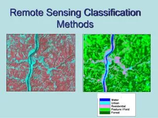
Image Classification (Making Maps) What does MMU mean? What is “land cover”?
Corn User’s Accuracy = 25/32 Accuracy Assessment
Change Detection 2003 1989 Also see THIS SITE
Thermal Remote Sensing Death Valley thermal image with north to right