Download
1 / 21
210 likes | 331 Views
Significance of Bathymetric Data in Polar and Marine Research … and Beyond. Norbert Ott & Hans Werner Schenke Alfred Wegener Institute for Polar and Marine Research Bathymetry und Geodesy Bremerhaven, Germany. Alfred Wegener Institute. Founded in 1980

E N D
Significance of Bathymetric Data in Polar and Marine Research… and Beyond Norbert Ott & Hans Werner Schenke Alfred Wegener Institute for Polar and Marine Research Bathymetry und Geodesy Bremerhaven, Germany
Alfred Wegener Institute • Founded in 1980 • Member of Helmholtz-Gemeinschaft Deutscher Forschungszentren (HGF) • ~800 Employees in Bremerhaven, Potsdam, Helgoland, and Sylt • Budget in 2006: ~100 Mio. Euro • Financing: 90% BMBF, 10% Fed. States • Scientific program with three faculties Geo, Bio und Climate • Logistics: 3 ships, 2 airplanes • 6 stations: Neumayer, Koldewey etc. INTERGEO 2008, Bremen
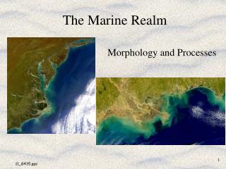
Bathymetry in Polar Research INTERGEO 2008, Bremen
Submarine Landslide Submarine Canyons Bathymetry in Marine Research INTERGEO 2008, Bremen
WHOI, 2002 Brown et al., 2006 www.physicalgeography.net Why Sea Floor Topography Matters? • Defines gates and barriers e.g. Drake Passage, Tasman Gateway • Steers global currents e.g. Antarctic Circumpolar Current • Thermohaline circulation • e.g. bottom water formation • Influences global climate • e.g. Antarctic glaciation INTERGEO 2008, Bremen
Geosciences Endogenous processes Exogenous processes Disaster management Oceanography Circulation and Flux Numeric Modeling Biology Ecology und Biodiversity Protection and conservation Observing systems Physical boundary Domains and Variables Grobe, 2000 NOAA, 2007 Carbotte et al., 2000 Applications INTERGEO 2008, Bremen
Scientific Projects Arctic Ocean • Fram-Strait (1997) • Gakkel-Ridge (2001) • IBCAO (current) • Southern Ocean • BCWS (1998-2001) • INT 9057, 9055 (current) • IBCSO (current) INTERGEO 2008, Bremen
Gakkel-Ridge in the Arctic Ocean • AMORE Expedition 2001 • Mid-ocean Ridge • 1800 km length, 3000 m height • Characteristics • Ultraslow spreading • Graben structure • thin crustal thickness • Amagmatic/aseismic (?) • Defined as new Type of MOR • cold and rigid crust INTERGEO 2008, Bremen
IBC of the Weddell Sea Bathymetric Data: GEBCO GDA IHO DCDB and HOs MB-Daten Topographic Data: ADD 1.94, 1994 INTERGEO 2008, Bremen
Smith & Sandwell, 1997 Schenke et al., 1998 Gravity vs. Bathymetry • Gravity • Herring bone pattern • Heterogenic gravity field • Density contrasts • Bathymetry • No Herring bone pattern • Homogenic Topography • Seismic findings • Sediments (~1000 m) • Smooth topography INTERGEO 2008, Bremen
Divins, NGDC, 2003 A Bath Tube After All? INTERGEO 2008, Bremen
Holland; 2001 Holland, 2001 NOAA, 1988 The Weddell Sea Polynya • Polynya – hole in sea ice • First in 1975, then in 1994 • Topography • Maud Rise (~3000 m) • Volcanic complex • Steering • Local vortex near the rise • Up-streaming currents • Energy transport - heat INTERGEO 2008, Bremen
NASA, USGS, 1999 Atmospheric Analogon Karman Vortices at Selkirk Island (SE Pacific) INTERGEO 2008, Bremen
Project „Coolchart“ Bathymetric Data: MB-Data, 1989-2007 BCWS, 1998 Topographic Data: Radarsat Mosaic, 1997 coast line, contours INTERGEO 2008, Bremen
IBC of the Southern Ocean Extension of the IBCSO Ship Tracks with existing Multibeam Data INTERGEO 2008, Bremen
Lythe et al., 2001 RAMP, 1997 The GIS Database • Bathymetric data of the SO • Raw data, Grids, contours and Charts • Topographic data of Antarctica • DEM, ice thickness, Subglacial topo. • Coastline, grounding line, ice edge • Additional data • Satellite imagery • Feature names • Limits of seas • Metadata INTERGEO 2008, Bremen
IOC of UNECSO, 2006 RADAR LIDAR SONAR Behrens et al., 2008 GITEWS: DHI, GKSS, AWI DEM in Tsunami Warning Systems INTERGEO 2008, Bremen
North Pole Bathymetry goes WWW Data Errors in Polar Regions INTERGEO 2008, Bremen
ENC Prototyp of New York City INTERGEO 2008, Bremen
HRSC 10 m resolution Global coverage of Mars Multi-spectral imagery Stereoscopic views ESA, DLR, FU Berlin, 2007 State-of-the-Art: Mars vs. Earth • Multibeam 100 m • Only local coverage • Color-coded DEM • Perspective views INTERGEO 2008, Bremen
Conclusions • Depth values provide digitaldata for numerical modeling by use of digital tool – with large data gaps in the polar areas. • Digital data processing enables the performance of GIS based analyses as well as the generation of thematic maps for improved visualization of the sea floor and its dynamic processes. • Bathymetric data of AWI are used for applications in the fields of Geo-, Bio- und Climate Sciences and for disaster management and safe navigation. • Integration of bathymetric data with additional geo-scientific data enables the observation und evaluation ofpolar ecosystems – and their conservation. INTERGEO 2008, Bremen