Download
1 / 51
510 likes | 528 Views
This article discusses the capabilities of the Hyperspectral Environmental Suite (HES) on GOES-R in capturing high spatial, spectral, and temporal resolution infrared measurements. It also explores the use of HES in dealing with clouds and its potential impact on severe weather forecasting.

E N D
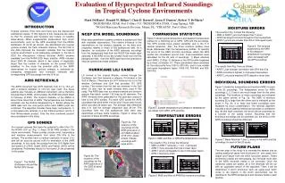
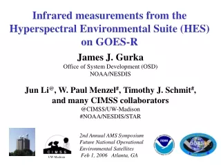
Infrared measurements from the Hyperspectral Environmental Suite (HES) on GOES-R James J. Gurka Office of System Development (OSD) NOAA/NESDIS Jun Li@, W. Paul Menzel#,Timothy J. Schmit#, and many CIMSS collaborators @CIMSS/UW-Madison #NOAA/NESDIS/STAR 2nd Annual AMS Symposium Future National Operational Environmental Satellites Feb 1, 2006 Atlanta, GA UW-Madison
Infrared measurements from the Hyperspectral Environmental Suite (HES) on GOES-R Heritage Sounders (GOES, NAST-I, IMG, AIRS, GIFTS) Hyperspectral Environmental Suite Dealing with Clouds Using ABI in tandem Summary 2nd Annual AMS Symposium Future National Operational Environmental Satellites Feb 1, 2006 Atlanta, GA UW-Madison
(~1600) HES (2012+) (~1600) GIFTS(2009?) The road to HES-IR (~1300) CrIS (2009-) (~8500) IASI (2005-) (~2400) AIRS (2003-) (~8600) NAST-I (1998-) (~23000) IMG (1997) (18) GOES Sounder(1994-) HES will be the first operational high spectral, spatial and temporal resolution instrument HIS (1986-) (12) VAS(1980-) VTPR, HIRS (1972, 1978-) IRIS (1969) time
GOES-8/M Sounder in 1994 18 Infrared Channels (1 Visible Channel) Filter Wheel Radiometer • Operational Sounder • Higher Signal-to-Noise
GOES axis of high LI indicates subsequent storm track 24 Jul 2000
Atmospheric Instability NWS Forecaster responses (Summer of 1999) to: "Rate the usefulness of LI, CAPE & CINH (changes in time/axes/gradients in the hourly product) for location/timing of thunderstorms." There were 248 valid weather cases. - Significant Positive Impact (30%) - Slight Positive Impact (49%) - No Discernible Impact (19%) - Slight Negative Impact (2%) - Significant Negative Impact (0) Figure from the National Weather Service, Office of Services
4 hrly LEO obs can’t monitor atm instability & cloud formation Observations every 4 hours are not often enough. Atmospheric process not observed.
GOES hourly observations help track atmospheric changes Monitoring atmospheric instability and cloud formation
Significant Findings from GOES-R Sounder OSSE Two polar orbiting interferometers (Leo) do not provide the temporal coverage to sustain forecast improvement out to 12 hours. Only the hourly Geo-Increased Spectral Resolution Sounder (Geo-I) observations depict moisture changes well enough for forecast benefit. OSSE 12 hr assimilation followed by 12 hr forecast
Atmospheric transmittance in H2O sensitive region of spectrum Studying spectral sensitivity with AIRS Data AIRS BT[1386.11] – BT[1386.66] Spectral change of 0.5 cm-1 causes BT changes > 10 C
Resolving absorption features in atmospheric windows enables detection of temperature inversions Texas Spikes down - Cooling with height (No inversion) Brightness Temperature (K) Spikes up - Heating with height Ontario (low-level inversion) GOES GOES Wavenumber (cm-1) Detection of inversions is critical for severe weather forecasting. Combined with improved low-level moisture depiction, key ingredients for night-time severe storm development can be monitored.
Guess CIMSS Physical Guess CIMSS Physical Inversion
Twisted Ribbon formed by CO2 spectrum: Tropopause inversion causes On-line & off-line patterns to cross 15 m CO2 Spectrum Blue between-line Tbwarmer for tropospheric channels,colder for stratospheric channels --tropopause-- Signature not available at low resolution
Inferring surface properties with AIRS high spectral resolution data Barren region detection if T1086 < T981 T(981 cm-1)-T(1086 cm-1) Barrenvs Water/Vegetated T(1086 cm-1) AIRS data from 14 June 2002
Hyperspectral Dust/Aerosol Modeling Negative Slope 880 to 920 cm-1– The Dust Signature Green – Clear Spectrum Effect of Dust Layer Location Effect of Dust Particle Sizes Negative slope kCARTA+DISORT, spectral resolution = 0.0025 cm-1
Anatahan Volcano viewed with AIRS Abs Scat Tot Ash signal 1228-995 cm-1 SO2 signal 1284-1345 cm-1 Anatahan 10 May 2003 (1554 UT) Tobin, CIMSS, 2004
Eye - Environment Temperature Eye Sounding Environment Sounding Isabel Eye Sounding from AIRS Integrate Hydrostatic Equation Downward from 100 hPa to Surface Environment Sounding: Ps = 1012 hPa Eye Sounding: Ps = 936 hPa Aircraft Recon: Ps = 933 hPa DeMaria, CIRA, 2004
Infrared measurements from the Hyperspectral Environmental Suite (HES) on GOES-R Heritage Sounders Hyperspectral Environmental Suite Dealing with Clouds Using ABI in tandem Summary 2nd Annual AMS Symposium Future National Operational Environmental Satellites Feb 1, 2006 Atlanta, GA UW-Madison
Future GOES in 2012 Future GOES will address all four key remote sensing areas * spatial resolution – what picture element size is required to identify feature of interest and to capture its spatial variability; * spectral coverage and resolution – what part of EM spectrum at each spatial element should be measured, and with what spectral resolution, to analyze an atmospheric or surface parameter; * temporal resolution – how often does feature of interest need to be observed; and * radiometric resolution – what signal to noise is required and how accurate does an observation need to be.
Sounder Comparison (GOES-Current to HES-Req) CurrentRequirement Coverage Rate CONUS/hr Sounding Disk/hr Horizontal Resolution - Sampling Distance 10 km 10 km - Individual Sounding 30-50 km 10 km Vertical resolution ~3 km 1 km Accuracy Temperature 2 deg. K 1 deg. K Relative Humidity 20% 10%
Aerosol Detection Surface Albedo Dust/Aerosol Aerosol Particle Size Surface Emissivity Probability of Rainfall Suspended Matter Vegetation Fraction Rainfall Potential Volcanic Ash Vegetation Index Rainfall Rate Aircraft Icing Threat Currents Atmospheric Vertical Moisture Profile Cloud Imagery Ocean Color Atmospheric Vertical Temperature Profile Cloud & Moisture Imagery Ocean Optical Properties Capping Inversion Information Cloud Base Height Ocean Turbidity Derived Stability Indices Cloud Layers / Heights & Thickness Sea & Lake Ice / Displacement & Direction Moisture Flux Cloud Ice Water Path Sea & Lake Ice / Age Pressure Profile Cloud Liquid Water Sea & Lake Ice / Concentration Total Precipitable Water Cloud Optical Depth Sea & Lake Ice / Extent & Characterization Total Water Content Cloud Particle Size Distribution Sea & Lake Ice / Extent & Edge Clear Sky Masks Cloud Top Phase Sea & Lake Ice / Surface Temp Radiances Cloud Top Height Absorbed Shortwave Radiation Sea & Lake Ice / Motion Cloud Top Pressure Downward Longwave Radiation Sea & Lake Ice / Thickness Cloud Top Temperature Downward Solar Insolation Ice Cover / Landlocked Cloud Type Reflected Solar Insolation Snow Cover Convection Initiation Upward Longwave Radiation Snow Depth Enhanced "V"/Overshooting Top Detection CO Concentration Sea Surface Temps Hurricane Intensity Ozone Total Energetic Heavy Ions Imagery: All-Weather / Day - Night SO2 Detection Mag Electrons & Protons: Low Energy Lightning Detection Derived Motion Winds Mag Electrons & Protons: Med & High Energy Low Cloud & Fog Microburst Wind Speed Potential Solar & Galactic Protons Turbulence Fire / Hot Spot Imagery Solar Flux: EUV Visibility Flood / Standing Water Solar Flux: X-Ray Geomagnetic Field Solar Imagery: X-Ray Land Surface (Skin) Temperature ABI – Advanced Baseline Imager HES – Hyperspectral Environmental Suite SEISS – Space Env. In-Situ Suite SIS – Solar Instrument Suite GLM – GOES Lightning Mapper Magnetometer 22 GOES-R Observational Requirements
HES • The Hyperspectral Environmental Suite (HES) will be located on a geostationary platform. • 2012 • NOAA operational • Currently in formulation phase • HES is an outgrowth of earlier ABS efforts • HES includes the functionality of the old Advanced Baseline Sounder (ABS)
HES-IR Tasks • HES - Disk Sounding (HES-DS) • Provide vertical moisture and temperature information, and other environmental data that will be used by NOAA and other public and private agencies to produce routine meteorological analyses and forecasts • Provide data that may be used to extend knowledge and understanding of the atmosphere and its processes in order to improve short/long-term weather forecasts. • HES - Severe Weather / Mesoscale (HES-SW/M) • Provide environmental data that can be used to expand knowledge of mesoscale and synoptic scale storm development and provide data that may be used to help in forecasting severe weather events. • Backup mode in the event of a GOES-R ABI failure (both).
HES-Disk Sounding (HES-DS) task • Spatial Resolution • IR: Threshold=10 km, Goal=2 km, • Vis: Threshold=1.0 km, Goal= 0.5 km • Coverage rate (Threshold) • 62 degree LZA / hour at 10 km resolution • Coverage area must be flexible and selectable.
UW/NOAA HES Targeted observations -- look where we need the information
HES-Severe Weather/Mesoscale task • Spatial Resolution • IR: Threshold=4 km, Goal=2 km, • Vis: Threshold=1.0 km, Goal= 0.5 km • Coverage rate • 1000 km x 1000 km (locations vary) in 4.4 minutes • Coverage area must be flexible and selectable. • Spectral coverage: • Specific examples are cited in the MRD, same as HES-DS • Spectral resolution: • 15 um CO2 band: 0.6 cm-1, Windows: 0.6-1.0 cm-1, Ozone: 1 cm-1, H2O: 1-2 cm-1, near 4 um: 2.5 cm-1, Visible: 0.18 um
Estimated (required) coverage times of typical areas at various spatial resolutions for the HES
100 100 Advanced Sounder (3074) GOES (18) Pressure (hPa) Pressure (hPa) 1000 1000 Moisture Weighting Functions High spectral resolution advanced sounder will have more and sharper weighting functions compared to current GOES sounder. Retrievals will have better vertical resolution. UW/CIMSS
GIFTS GIFTS HES ___ HES __________ HES _____ Current GOES, GIFTS and possible HES spectral coverage Spectral coverage details are not yet fully defined.
IR Spectral Coverage (DS or SW/M) HES’ HES Note that 5
spectral coverage spectral resolution HES 6 bands (red): LWCO2[718-800](0.625) + LWW[800-990](0.625) + SWW[1075-1200](0.625) + LWH2O[1210-1666](1.25) + SWH2O[1666-2150](1.25) + SWCO2[2150-2400](2.5) CrIS (blue): LW[650-1095](0.625) + MW[1210-1750](1.25) + SW[2155-2550](2.5) GIFTS (green): LW[685-1200](0.625) + SW[1650-2250](0.625) HES 3 bands (black): LWW[800-990](0.625) + LWH2O[1210-1666](0.625) + SWCO2[2150-2400](2.5)
Infrared measurements from the Hyperspectral Environmental Suite (HES) on GOES-R Heritage Sounders Hyperspectral Environmental Suite Dealing with Clouds Using ABI in tandem Summary 2nd Annual AMS Symposium Future National Operational Environmental Satellites Feb 1, 2006 Atlanta, GA UW-Madison
F3: Thick ice clouds 1km MODIS classification mask superimposed to AIRS footprints AIRS BT(K) @ 901.69 cm-1
Profile Retrievals in Cirrus Clouds with NAST-I GOES IR (2208UT) GOES IR (2208UT) May 30, 2002 o o SRL Flight Track o o SRL Flight Track GOES Visible (2208 UT) Thin cirrus produces little effect on retrieval NASA SRL data May 30, 2002 (19.5 – 23 UT) (37.8N, 100W) Aerosol Backscatter
Infrared measurements from the Hyperspectral Environmental Suite (HES) on GOES-R Heritage Sounders Hyperspectral Environmental Suite Dealing with Clouds Using ABI in tandem Summary 2nd Annual AMS Symposium Future National Operational Environmental Satellites Feb 1, 2006 Atlanta, GA UW-Madison
Spatial Temporal resolution resolution Cloud masking Improved products will be realized from combinations of ABI and HES (Hyperspectral Environmental Suite) data (IR and Visible/near IR on the HES-Coastal Water)! ABI HES Spectral coverage Surface emissivity Spectral resolution
Using collocated ABI to help HES for sounding and cloud property • HES sub-pixel cloud characterization using ABI masks (cloud mask, cloud phase mask, and cloud classification mask) (Li et al. 2004, JAM) • Using ABI and HES for cloud property retrieval during night (Li et al. 2005a, JAM) • Using ABI for HES cloud-clearing (Li et al. 2005b, IEEE TGRS)
F3 F2 F1 AIRS Window BT(K) Water Land L. Cld Mid Cld L. Cld H. Cld H. Cld Mid Cld Mid. Cld MODIS 1km classification mask superimposed to the AIRS footprints of the study area. The ABI masks (cloud masks, cloud phase mask, and classification mask) can be used for HES sub-pixel cloud characterization.
F1: CTP=251, CPS=47.56, COT=0.34 F2: CTP=248, CPS=67.50, COT=1.18 Wavenumber (cm**-1) F1 F2 AIRS BT(K) @ 901.69 cm-1 1km MODIS classification mask
Using ABI for HES cloud-clearing • ABI and HES see the same IR spectral regions • ABI can be used for QC on HES cloud-cleared radiances and sounding retrieval
Aqua MODIS IR SRF Overlay on AIRS Spectrum Direct spectral relationship between IR MODIS and AIRS provides unique application of MODIS in AIRS cloud_clearing !
AIRS clear (13.5 km) AIRS clear + CC-S (13.5 km) MODIS clear (1 km)
AIRS clr + CC BT ( convolved to MODIS 6.7 um band) AIRS granule 184 of Sept 24, 2004
AIRS BT (All) AIRS BT (Cloud-Cleared) AIRS BT (Clear Only)
Infrared measurements from the Hyperspectral Environmental Suite (HES) on GOES-R Heritage Sounders Hyperspectral Environmental Suite Dealing with Clouds Using ABI in tandem Summary 2nd Annual AMS Symposium Future National Operational Environmental Satellites Feb 1, 2006 Atlanta, GA UW-Madison
GOES-R HES temporal (hourly), spectral (~1 cm-1), spatial (4-10 km), & radiometric (~0.1 K) capabilities will * depict water vapor as never before by identifying small scale features of moisture vertically and horizontally in the atmosphere * track atmospheric motions much better by discriminating more levels of motion and assigning heights more accurately * characterize life cycle of clouds (cradle to grave) and distinguish between ice and water cloud ( very useful for aircraft routing) and identify cloud particle sizes (useful for radiative effects of clouds) * measure surface temperatures (land and sea) by accounting for emissivity effects (improved SSTs useful for sea level altimetry applications) * distinguish atmospheric constituents with improved certainty; these include volcanic ash (useful for aircraft routing), ozone, and possibly methane plus others trace gases.
Summary * GOES Sounder utilization is still evolving; there is another decade of opportunity * Excellent data sets are being gathered to facilitate hyperspectral sounder science and algorithm development (GOES-R3 & GOES AWG) * The right balance of spatial, temporal, spectral, and radiometric capabilities must be specified * Combination of ABI and HES will give new and improved products