Download
1 / 27
270 likes | 457 Views
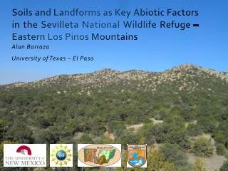
Soils and Landforms as Key Abiotic Factors in the Sevilleta National Wildlife Refuge – Eastern Los Pinos Mountains. Alan Barraza University of Texas – El Paso. Los Pinos Mountains. Southern part of a mountain system that extends northward along the Rio Grande Rift.

E N D
Soils and Landforms as Key Abiotic Factors in the Sevilleta National Wildlife Refuge – Eastern Los Pinos Mountains Alan Barraza University of Texas – El Paso
Los Pinos Mountains Southern part of a mountain system that extends northward along the Rio Grande Rift. Uplifted during Laramide Orogeny (40-70 Ma) and Rio Grande Rift formation (25 –0 Ma) Pre-Cambrian age rocks (1.8 BA). Composedof the Sias quartzite (oldest), Blue Springs muscovite schist(originally siltstones), White Ridge quartzite, and Sevilletarhyolite, all intruded by the Los Pinos (pre-Cambrian) granite. (Stark et al, 1946; Luther et al., 2005)
Importance of Regolith and Soil • Regolith and soil can absorb and retain more water than bedrock • Nutrients can be extracted easily compared to little to no extraction in bedrock • Provides the environment needed for the most species of plants to grow.
Importance of Study • Gain a general understanding of the following: • landforms present in the eastern side of Los Pinos Mountains. • processes occurring that are creating regolith and soil in the area • abiotic factors affecting plant growth
Hypotheses • Soil thickness will be correlated with landform, gradients of slopes, and aspect. • Different landforms will entrap and incorporate dust at variable rates, given differences in landform morphology and age. • This is because the source of the majority of soil material (i.e., clay, carbonate, silt) in analogous landforms elsewhere in semiarid slopes of NM is dust. • Highest plant biomass and diversity will occur in the older Quaternary alluvial fill, given additional void space for soil water storage and higher soil water retention associated with clay and silt. Plant growth on the pediment will be influenced by thinner soil development. South and north facing slopes will be differently related to plant recruitment and productivity, primarily given soil differences associated with slope-controlled rates and processes of soil development.
Field Methods • Mark out a 1meter x 1meter plot • Characterization of site: • GPS coordinates • Slope and aspect of the area • Qualitative description of the surrounding area to include vegetation, clast size, and any other items of interest • Photography of area • Transects • Create 2 diagonal transects across the set plot • Every 10cm along each set transect, identify and measure rocks directly on the transect line and under set mark
Field Methods (cont) • Soil Analyses • Excavate a small hole (approximately 20cm x 20cm) until bedrock is reached. • Collect a grab sample and run the soil through the soil sieve to remove all gravel and rocks. • Analyze a dry soil ped for soil hardness • Using 10% HCl, test the soil for any CaCO3. • Analyze soil for wet consistency, plasticity, soil type identification using the ‘worm test’ • Measure depth of hole and approximate vegetation coverage in plot • Take note of root content
Discussion • Very scattered results supports the idea of several processes taking place creating the various landforms. • Closely correlated soil thickness and similar clast sizes on all pediment surfaces suggest that these landform are entrapping and incorporating dust at similar rates. • Thicker soil and smaller clasts on alluvial surfaces demonstrate a different process taking place in the formation of these landforms. • With a higher sampling size soil thickness versus slope gradient could possibly be highly correlated. • Most plant data was very scattered. But, spatial distribution of piñon trees between older Quaternary alluvial fill and the pediment surface shows trees prefer the thinner soil. The majority of this soil is eolian dust thus could be better formed and better suited for plant recruitment.
Conclusion • Significant correlation between soil thickness and landform • Approaching significant correlation between soil thickness and slope gradient. • No significant correlation between soil thickness and azimuth • Highest plant biomass did not occur on the older Quaternary alluvial fill, but instead on pediment surface. Plant biomass and soil thickness between pediment surface and slopes were not significantly different. • Larger clast size does entrap more dust and this is apparent in the soil thicknesses of the various landforms except for the alluvial surfaces, and mountain summit which are undergoing different processes.
Further Questions… • What difference in the soil between the older Quaternary alluvial fill and the pediment surface is causing such a significant difference in piñon tree biomass? • Where is the eolian dust forming? • Why are do some species of plants dominate certain landforms? • When where the various alluvial fills created?