Download
1 / 15
150 likes | 259 Views
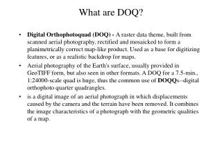
This document outlines the process of transferring and remapping existing CBRS lines onto digitally ortho-rectified aerial photography (DOQ). The remapping involves three types of boundary adjustments: aligning with DOQ imagery, capturing the original boundary intent, and accommodating geomorphic changes according to recent legislation. Key actions include coordinating with land managers, analyzing historical development data, and utilizing digital parcel data for precision. The transition to DOQ imagery provides enhanced visual cues, improving boundary accuracy and identifying existing developments.

E N D
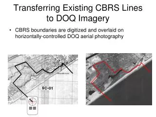
Transferring Existing CBRS Lines to DOQ Imagery • CBRS boundaries are digitized and overlaid on horizontally-controlled DOQ aerial photography
Remapping FSUs • Three types of boundary adjustments are required: • Changes to “fit” DOQ imagery • Adjustments to match documented boundary intent • Changes to account for geomorphic change as mandated by the 5-year review legislation
FSU Changes to “Fit” DOQ Imagery • Note boundary relationship to road • Note location of features for alignment
FSU Adjustments to Reflect Intent • Administrative Record indicates boundary was intended to exclude existing development • Note boundary relationship to infrastructure on 1979 base map
FSU Adjustments to Reflect Intent • Administrative Record indicates boundary was intended to exclude existing development • Note boundary relationship to infrastructure on 1979 base map • Note boundary relationship to construction completed 1981
FSU Adjustments to Reflect Intent • Refinement of boundaries based on digital property parcel data • Note boundary relationship to trailer park identified on 1979 base map
FSU Adjustments to Reflect Intent • Research indicates this FSU should follow specific property boundaries. The digital parcel data (in purple below) allows the CBRS boundaries to be adjusted to reflect intent.
FSU Geomorphic Changes • Note boundary relationship to stream
FSU Geomorphic Changes • Note boundary relationship to stream
Remapping OPAs • OPA remapping is significantly different from FSU remapping • All owners / managers of protected lands must be contacted • Intensive outreach and coordination is key • Examples follow to demonstrate: • Transferring existing OPA boundaries to DOQs • Overlaying parcel data representing multiple landowners • Adjustment of CBRS lines to property / parcel data
Remapping OPAs • Note location of features for alignment
Remapping OPAs • Overlay County parcel data • Determine 1990 land ownership • Identify potential addition issues Private Dauphin Island Park & Beach Board U.S. Coast Guard Sea Lab (University of Alabama) DIPB Board land Leased to Sea Lab DIPB Board RV park (not desired for inclusion)
Stakeholder Concurrence Remapping OPAs • Coordinate with land managers to “fit” boundaries to photographic base • Obtain land manager’s signature to show concurrence that OPA includes only eligible, intended lands Stakeholder Signature US FWS Signature
Private Dauphin Island Park & Beach Board U.S. Coast Guard AL-05P Sea Lab (University of Alabama) AL-05P DIPB Board land Leased to Sea Lab DIPB Board RV park (not desired for inclusion) Remapping OPAs • Recommended OPA boundary
Benefits of Digital Orthophoto Base Map • Visual cues facilitate identification of existing development • Enhanced precision in mapping geomorphic features • Location of planimetric features • Ability to overlay and analyze digital parcel data • Horizontal spatial control of boundary lines