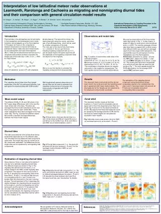
Download
1 / 22
220 likes | 302 Views
CUAHSI HIS is a platform for organizing & publishing hydrologic datasets, with capabilities for data discovery, integration, and Spatial Services.

E N D
Introduction to HydroServer and the Observations Data Model (ODM) http://his.cuahsi.org/ Jeffery S. Horsburgh Utah Water Research Laboratory Utah State University CUAHSI HIS Sharing hydrologic data Support EAR 0622374
CUAHSI HIS The CUAHSI Hydrologic Information System (HIS) is an internet based system to support the sharing of hydrologic data. It is comprised of hydrologic databases and servers connected through web services as well as software for data publication, discovery and access. Data Discovery and Integration platform HIS Central Like search portals Google, Yahoo, Bing Metadata Search Metadata Services Service and data theme metadata Service registration Data carts Catalog harvesting Data Services HydroServer HydroDesktop Data Synthesis and Research platform Data Publication platform Water Data Services Spatial Data Services Like HTML Like web servers Like browsers
HydroServer Goals • A platform for organizing and publishing space-time hydrologic datasets that: • Provides local control of data • Makes data universally available • Is autonomous – e.g., functional independent of the rest of HIS
Capabilities Database Configuration Tool HydroServer Capabilities Database WaterOneFlow Services Spatial Services WaterOneFlow WaterOneFlow WaterOneFlow ODM ODM ODM ODM Databases and Web Services ArcGIS Server Spatial Data Services
HydroServer Regions • A region is an experimental watershed, research site, etc. for which data are published • Little Bear River Experimental Watershed • Reynolds Creek Experimental Watershed • T.W. Daniels Experimental Forest • Organizing concept for HydroServer • One or more ODM databases/WaterOneFlow services for a region • One or more geospatial data services for a region
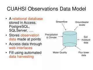
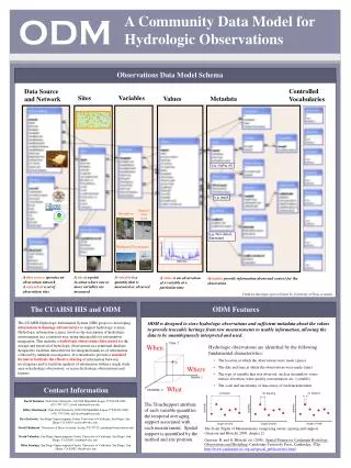
Observations Data Model (ODM) Streamflow Groundwater levels Precipitation & Climate Soil moisture data Flux tower data Water Quality • A relational database at the single observation level • Metadata for unambiguous interpretation • Traceable heritage from raw measurements to usable information • Promote syntactic and semantic consistency • Cross dimension retrieval and analysis Horsburgh, J. S., D. G. Tarboton, D. R. Maidment, and I. Zaslavsky (2008), A relational model for environmental and water resources data, Water Resources Research, 44, W05406, doi:10.1029/2007WR006392.
“When” Time, T t A data value vi (s,t) “Where” s Space, S Vi “What” Variables, V What are the basic attributes to be associated with each single data value and how can these best be organized?
Data Series – Metadata Description Time End Date Time, t2 There are C measurements of Variable Vi at Site Sj from time t1 to time t2 Count, C Begin Date Time, t1 Site, Sj Space Variable, Vi Variables
Series Catalog Time Sj End Date Time, t2 Vi Count, C Begin Date Time, t1 Site, Sj Space Variable, Vi Variables t1 t2 C
ODM Controlled Vocabularies HIS CV Website ODM Data Manager ODM Tools ODM Controlled Vocabulary Moderator XML Master ODM Controlled Vocabulary Local ODM Database ODM Controlled Vocabulary Web Services Local HydroServer
Loading Data into ODM ODM Data Loader • Interactive ODM Data Loader • Loads data from spreadsheets and comma separated tables in simple format • Streaming Data Loader (SDL) • Loads data from datalogger files on a prescribed schedule • Interactive configuration • SQL Server Integration Services (SSIS) • Microsoft application accompanying SQL Server useful for programming complex loading or data management functions ODM SDL SSIS
Managing Data Within ODM - ODM Tools • Query and export – export data series and metadata • Visualize – plot and summarize data series • Edit – delete, modify, adjust, interpolate, average, etc.
Set of query functions ReturnsdatainWaterML Publishing Data in an ODM Database WaterMLand WaterOneFlow WaterML is an XML schema for communicating water data WaterOneFlow is a set of web services based on WaterML Slide from David Valentine
Publication of Geospatial (GIS) Datasets • Publishing spatial datasets using ArcGIS Server • Using OGC standards that can be consumed by a number of GIS clients • WMS, WFS, WCS
Data Presentation Via a Map Interface • Internet Map Server built using ArcGIS • Web browser client • Combine spatial data and observational data • Launch data visualization tools • Based on a “Region” http://maps.usu.edu/map/
Data Preview, Visualization, and AnalysisTime Series Analyst • Web Browser Client • Multiple ODM Database Support • Variety of plot types • Descriptive statistics • Linked to the map application • Data preview and download http://icewater.usu.edu/tsa/
HydroServerWebsite • HydroServer home page • Observational data services • GIS data services • Online map • Time Series Analyst • Data Query and Download http://icewater.usu.edu
HydroServer Capabilities Database • Simple Windows application for creating metadata records in your database • Associating Regions with services and maps HydroServer Capabilities Database Configuration Tool
HydroServer Capabilities Web Service • Publish capabilities of each HydroServer • Listing of published observational data services • Listing of published spatial data services • Supports automatic cataloging of available services at HIS Central • Makes HydroServers self describing Catalog Catalog Services Metadata Services Data Services Server Desktop
Summary • HydroServer provides a self contained autonomous data publication system • Local control of data, but universally accessible • Downloadable user (data publisher) configurable software stack that contains: • ODM and associated tools • WaterOneFlow web services • Geographic data sharing using WFS, WCS, WMS from ArcGIS server • Time Series Analyst • ArcGIS server based web map application • HydroServer Capabilities web service that publishes metadata about regions and services (observational and spatial)
Questions? http://his.cuahsi.org/ CUAHSI HIS Sharing hydrologic data Support EAR 0622374