Download
1 / 38
380 likes | 482 Views
Solve the issue of insufficient terrain data for mission planning in the proliferation of command control systems. Stakeholder analysis, data layers, simulations, findings, and recommendations. Future plans for improving terrain databases.

E N D
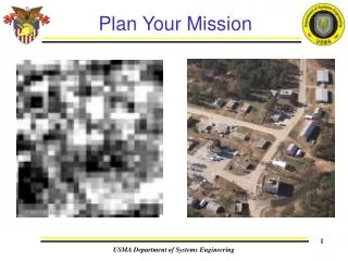
Plan Your Mission USMA Department of Systems Engineering
Tactical Command and Control Data Requirements Team Cadet Michael Chun Operations Research Michael.Chun@usma.edu Cadet Christopher Grevious Engineering Management Christopher.Grevious@usma.edu Cadet Guillermo Guandique Systems Engineering Guillermo.Guandique@usma.edu Cadet Eugene Page Engineering Management Eugene.Page@usma.edu LTC Rob Kewley Advisor Robert.Kewley@usma.edu Left to right: Mike Chun, Guillermo Guandique, Chris Grevious, Gene Page USMA Department of Systems Engineering LTC Rob Kewley Advisor (845) 938-5206, Fax: (845) 938-5919 Robert.Kewley@usma.edu LTC Rob Kewley Advisor (845) 938-5206, Fax: (845) 938-5919 Robert.Kewley@usma.edu
Agenda • Problem Overview • Clients • Stakeholder Analysis • Data Layers • Simulation • Findings • Conclusions • Recommendations • Future Work USMA Department of Systems Engineering
Problem Description • Proliferation of Command Control Systems hitting the Force Today • All systems have a requirement for terrain data • With higher quality data, systems can be better used for mission planning • Consumers: Want perfect data, extremely detailed data • Producers: Don’t have the resources to provide this USMA Department of Systems Engineering
Terrain Data Assessment • Problem Statement: Provide information to assist in creating realistic terrain databases for operational testing of the Army’s Future Combat Systems • Providing adequate, realistic data for mission planning and execution. USMA Department of Systems Engineering
Overview • Terrain Databases are used for various military operations. • Key Issues: • Too much data (exceeding network bandwidth). • Limited information/intelligence for a given area. • Different data formats between source data and final product. USMA Department of Systems Engineering
Stakeholder Analysis • Purpose: Identify functions, objectives, constraints, and measures of the problem • Stakeholders • End Users: Tactical Level Commanders, Maneuver Unit Soldiers • US Army Topographic Engineering Center (TEC) • Future Combat Systems (FCS) USMA Department of Systems Engineering
Future Combat Systems (FCS) Image Taken From http://www.globalsecurity.org/military/systems/ground/fcs.htm USMA Department of Systems Engineering
Mission Provide the warfighter with a superior knowledge of the battlefield and to support the nation's civil and environmental initiatives. This mission is accomplished through research, development, and the application of expertise in the topographic and related sciences. Primary Client Supporting TEC by providing feedback and studies on cost and value analysis in C2 Systems. Concern If FCS is based on perfect data, that is not how it will perform in theater Topographic Engineering Center (TEC) USMA Department of Systems Engineering
Stakeholder Analysis • Findings • Detailed 3D imagery was greatly desired • Up to date (FBCB2 style) tracking and situation data was critical • Difficult to replace recon, but could aid in recon • Lack of comfort with digital systems • Conclusions • Current platforms could be improved on • Training and Education were necessary • Company level needs easy access to timely situation data • A common operational picture is more effective than systems running in parallel USMA Department of Systems Engineering
Functional Analysis USMA Department of Systems Engineering
Overall Capstone Design • Terrain Generation Team • Assess the cost of data • Build terrain layers for command control simulation • Identify the realistic features of terrain data to be used in operational testing • Command and Control Team • Assess the value of data • Conduct simulation and analysis • Identify critical features of terrain data to be incorporated into FCS USMA Department of Systems Engineering
Levels of Detail • Designed three different scenarios to test terrain data sufficiency: • Low Level (basic “off-the-shelf” data) • Medium Level (basic data plus significant analysis) • High Level (extensive analysis, additional intelligence) USMA Department of Systems Engineering
Levels of Detail Slide Taken from Terrain Generation Team USMA Department of Systems Engineering
Data Layers • In order to make a working database there are a few things that we will have to consider. Each level of resolution is dependent on how much time notice we have and how much control we have in the area or interest. • All data was obtained from off the shelf data from the National Geospatial-Intelligence Agency (NGA) or other commercial sources. • Layer 1 (Low) – Least time available – 4 Meter Resolution. • Layer 2 (Medium) – Week(s) Notice. DTED Layer 2 (Quickbird) – • Limited Airspace control/No ground control. • Layer 3 (High) – All Technically Possible (LIDAR) • Full Air/Ground Control Slide Taken from Terrain Generation Team USMA Department of Systems Engineering
Digital Terrain Elevation Data • From DTED 5 to 1 the storage space required decreases to between 8-10% of the previous level. • Only about a 24 hour difference in man hours between best and worst. • Biggest concern is Operational status pre-deployment to boots on ground. Slide Taken from Terrain Generation Team USMA Department of Systems Engineering
Design of Experiment • Critical to identify what is most important to warfighter in a resource intensive environment • Live simulation of the planning phase of an operation • Utilized 3 levels of terrain data: low, medium, and high detail • Convoy and Raid Operations Planned • System Users: • Army Engineer Officer • Army Cavalry NCO • Maneuver Control System USMA Department of Systems Engineering
Simulation Purpose • Analyze value of available terrain data • Plan mission with varying levels of detail • Determine necessity of features • Provide feedback and suggestions USMA Department of Systems Engineering
Mission 1st Platoon, Alpha Company, TF 1-1 will depart from FOB Eagle at VQ81513789 and conduct raid operations at OBJ Raptor (VQ88554139) NLT 0900 02APR2007 to support stability operations. • Known enemy activity along major built up MSR’s. • Area of operations at OBJ Raptor known to be very hostile. USMA Department of Systems Engineering
Area of Operations USMA Department of Systems Engineering
OBJ Raptor USMA Department of Systems Engineering
Detail Level 1: Area of Operations USMA Department of Systems Engineering
Detail Level 1: Objective Raptor USMA Department of Systems Engineering
Detail Level 2: Area of Operations USMA Department of Systems Engineering
Detail Level 2: Objective Raptor USMA Department of Systems Engineering
Detail Level 3: Area of Operations USMA Department of Systems Engineering
Detail Level 3: Objective Raptor USMA Department of Systems Engineering
Detail Level 3: Objective Raptor USMA Department of Systems Engineering
Simulation Findings • Raid Operations increased in complexity with level of detail • Avenues of approach were easily identified at Medium layer • Initial convoy route did not change but initial raid planning did. • Most Commonly used features: • Line of Sight (Military Analyst) • .6 Meter Imagery • Elevation • Road Conditions USMA Department of Systems Engineering
Low Level Findings • Low Level Data • Too many uncertainties due to low level resolution • Limited info on route • Unfamiliar with area of operations • Unable to anticipate enemy attacks • Unable to efficiently plan entrance routes • Unable to visualize obstacles • Most Useful Features • Roads, villages, very limited identification • Most Needed Features • Vegetation, elevation, village photography. USMA Department of Systems Engineering
Medium Level Findings • Able to identify several routes in/out of village • Well identified assault and support positions • Able to anticipate possible enemy attack positions • Able to plan entrance route • Able to plan exit route • Able to identify obstacles • Most Useful Features • Building data • Line of Sight using vegetation data • Routes • Most Needed Features • Updated Vegetation • Updated imagery USMA Department of Systems Engineering
Able to identify “areas of concern” Emplaced overwatch position, support by fire, and assault position. Able to estimate enemy exit route Able to anticipate enemy attack Easily identified exit and entrance routes Easily identified possible obstacles Most Used Features Line of Sight tool Route trafficability Aerial/Ground photography LIDAR data Most Needed Features Building structure information High Level Findings USMA Department of Systems Engineering
Results Compiled USMA Department of Systems Engineering
Results Compiled USMA Department of Systems Engineering
Conclusion • Data Development • Collected by space based assets • DTED 1, 2, and 3 • .6 meter imagery • Must focus on a specific area • Feature layers are manpower intensive • Roads, vegetation, and urban areas are easiest to create • Marshes, streams, and rivers are most difficult to create • Categorization of urban areas requires human intelligence • Ground Photography • Data Value • Need at least .6 meter imagery for effective mission planning • Need at least DTED 2 elevation data to accurately incorporate terrain features into planning • Roads, bridges, and trafficability are critical features • Vegetation can be easily seen on imagery • Photographs taken on the ground facilitate detailed planning • LIDAR data is useful but not critical to mission planning USMA Department of Systems Engineering
Recommendations • Elevation Data- Use DTED 2 elevation data (without LIDAR) in conjunction with Line of Sight tools • Aerial Photography- Use Quickbird .6 meter resolution for FCS testing • Feature Data- Utilize general feature data ie roads, bridges, water, buildings • Tactical Situation-Assume limited airspace/no ground control, adjust available data based on progress of operations/terrain build time USMA Department of Systems Engineering
Future Work • Continue to Analyze the Cost versus Value • Individual attributes at varying levels of detail • Individual cost for varying attributes • Replicate the simulation at Fort Bliss for FCS Operational Testing with the same types of terrain data • Work at Fort Bliss will be used for conclusions for same types of testing, but equipment and soldiers will be incorporated to increase complexity USMA Department of Systems Engineering
Questions USMA Department of Systems Engineering