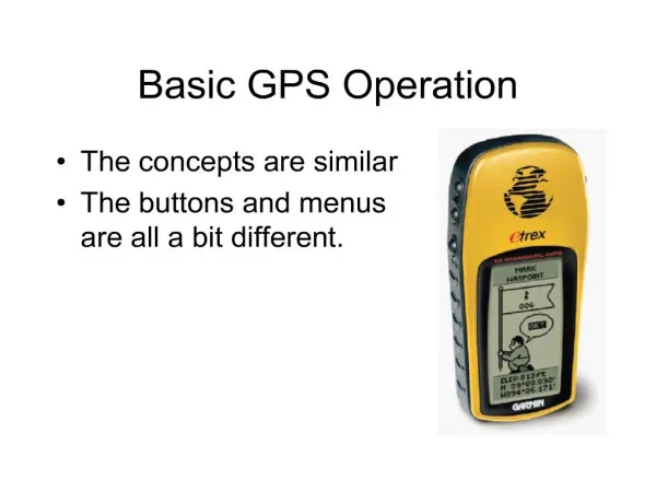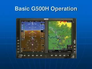
Basic G500H Operation
Basic G500H Operation. Primary Flight Display. The Difference in the Dials. Altitude. Airspeed. Attitude. Vertical Speed. DG/HSI. Airspeed Indicator. Actual Airspeed. Speed Indications. Speed Ranges. GS & TAS Boxes. Airspeed References. Trend Vector. Attitude Indicator.


Basic G500H Operation
E N D
Presentation Transcript
The Difference in the Dials Altitude Airspeed Attitude Vertical Speed DG/HSI
Airspeed Indicator Actual Airspeed Speed Indications Speed Ranges GS & TAS Boxes Airspeed References Trend Vector
Attitude Indicator Sky Representation Roll Scale Roll Pointer Aircraft Wingtips Horizon Aircraft Symbol Pitch Scale Land Representation
Altimeter Current Altitude Altitude Values Altitude Reference Bug Altitude Reference Box Trend Vector Barometric Setting Box
Vertical Speed Indicator Vertical Speed Bug is set Climb or descend To guide the Needle Into the bug
Horizontal Situation Indicator Digital Heading Heading Trend Vector Heading Box Nav Source Flight Phase Course Box Lateral Deviation Scale Heading Bug TO/FROM Indicator Compass Rose Course Pointer Airplane Symbol OBS Mode
Where are the needle and ball? “Step on the Bar” Slip & Skid Turn Rate Indicator Half Standard Rate Standard Rate If rate of turn >25 degrees….
Additional information on PFD Navigation status window Traffic Data Terrain/Obstacle
Primary Flight Display (PFD) Bezel Controls Heading Bug Course Selection Altitude Selection Vertical Speed Bug Barometric Adjustment
MFD Overview • Classic Garmin “Chapter/Page” layout • Page Groups or “Chapters” • Map page group • Weather page group • Auxiliary page group • Flight Plan page group • Tips • Soft keys offer short cuts to many actions • Holding “CLR” for two seconds takes you back to the default Navigation Map 1 page
Page Group Icon The Page Group Icon shows which page group and page you are viewing. Page group indicator Selected page indicator Selected page group is highlighted Map page group Weather page group Auxiliary page group Flight Plan page group
Map Page Group Terrain Nav Map 2 Traffic (opt) Nav Map 1
Weather (WX) Page Group (opt) 3. Wx Data Link Map 3 1. Wx Data Link Map 1 2. Wx Data Link Map 2
AUX Page Group 3. XM Radio (opt) 1. System Setup 2. XM Information (opt) 4. System Status
Flight Plan Page Group 3. Chart Page (Opt) 2. Waypoint Information 1. Active Flight Plan
SafeTaxi • Features: • Display of full airport terminal diagrams seamlessly integrated on main navigation map • Geo-referenced data with selectable attributes including: • All current runways and taxiways • FBO names and locations • Public services (terminal locations, fire dept., post office, etc.) • Display of diagram data on PFD inset map • Database: • U.S. coverage only - limited to 653 airport diagrams defined by NACO • 56 day database update cycle to be combined with current obstacle DB cycle • Activation: • Functionality display enabled if appropriate database is present - no unlock card required • $35 per cycle or $195 per year subscription • Available on Garmin website
Terrain Awareness • Forward Looking Terrain Avoidance (FLTA) function • Premature Descent Alert (PDA) function • Excessive Decent Rates (EDR) function • Negative Climb Rate (NCR) (or Altitude Loss After Take-off) function • Visual caution and warning alerts
Terrain Awareness • Yellow = aircraft within 1000’ AGL of terrain • Red = aircraft within 100’ or below elevation of terrain • Does not account for trees, power-lines, etc.
Obstacle Symbols The following symbols are used to represent different forms of obstacles:
Victor Airways and Jetways • Victor ( V ) Low altitude airways (below 18,000 feet [5,500m] MSL) • Jetways ( J ) High Altitude Airways (above 18,000 feet [5,500] MSL)
(Opt) GDL 69(A) Capabilities for the G500H High-resolution NEXRAD weather data METARs (graphical and textual format) TAFs, TFRs, Winds aloft (at altitude) Echo tops, Cloud tops Freezing Levels, Lightning Storm-cell data (size, speed and direction) AIRMETs SIGMETs County Warnings Surface Analysis, City Forecast XM Radio with purchase of the GDL69A
Weather Legends Weather Legends
GDL-69 Weather Nexrad Broadcast rate: 5 minutes
GDL-69 WeatherEcho Tops Broadcast rate: 7.5 minutes
GDL-69 WeatherCloud Tops Broadcast rate: 15 minutes
GDL-69 WeatherLightning Broadcast rate: 5 minutes
GDL-69 Weather Cell Movement Broadcast rate: 1.25 minutes
GDL-69 WeatherAIRMETs / SIGMETs Broadcast rate: 12 minutes
METARs Graphical METAR Broadcast rate: 12 minutes
GDL-69 WeatherSurface Observation Broadcast rate: 12 minutes
GDL-69 WeatherFreezing Level Broadcast rate: 12 minutes
GDL-69 WeatherWinds Aloft Broadcast rate: 12 minutes
GDL-69 Weather County Warnings Broadcast rate: 5 minutes
GDL-69 Weather TFR Broadcast rate: 5 minutes