Download

1 / 15
150 likes | 372 Views
This image is a visualization of the Earth with lines of latitude and longitude shown. How are lines of latitude and longitude drawn on a globe of Earth?. Latitude lines are parallel and longitude lines meet at the poles Latitude lines are parallel and longitude lines meet at the equator

E N D
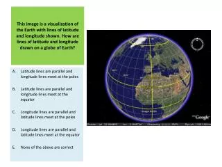
This image is a visualization of the Earth with lines of latitude and longitude shown. How are lines of latitude and longitude drawn on a globe of Earth? Latitude lines are parallel and longitude lines meet at the poles Latitude lines are parallel and longitude lines meet at the equator Longitude lines are parallel and latitude lines meet at the poles Longitude lines are parallel and latitude lines meet at the equator None of the above are correct
On the left side of this satellite image the Indian subcontinent can be seen. In which general direction is this image oriented? North South East West Up
In geography, big numbers are often used. How many millions are there in a billion? 10 100 1000 10000 100000
The figure shows a series of 3 maps of Lancaster, England. Which of the maps is of the largest scale? The map labeled “Level 1” The map labeled “Level 2” The map labeled “Level 3” They are all the same scale They are of different scales, but it is impossible to tell which scale is larger or smaller
An airplane takes off from a location at 17°S latitude and flies to a new location 55° due north of its starting point. What latitude has the plane reached? 28°N 38°N 55°N 72°N 38°S
Base your answer to this question on the topographic map shown here. Points X, Y, and Z are locations on the map. Elevations are expressed in meters.What is the elevation of point Z? 190 m 220 m 240 m 250 m None of the above
On the left side of this satellite image part of the continent of Africa can be seen. A section of desert can be seen there. Whatis the name of this desert? Sahara Desert Gobi Desert Kalahari Desert Mohave Desert Atacama Desert
Which of the following indexes was developed by the United Nations in order to determine the ‘quality of life’ of people in a particular area? Gini Index Human Development Index Gross National Happiness Index Gross Domestic Product Index All of the above
Which two continents can be seen in this satellite image? Africa & South America Asia & Europe North America & Europe North America & Africa None of the above are correct
According to this map, which region in the United States was warmer than average during November and December 2008? Northeast North / Great Lakes Southwest None of the above were warmer during November to December 2008 All of the above were warmer during November to December 2008
The image in this aerial photograph is most likely… …a school …an airport …a ferry terminal …private housing …a hospital
At which grid reference can the lake be found on the map shown here? G5 B2 H1 F4 A4
What does this dot map of China most likely show? The location of mosques in the country Population density Areas of food production Areas with high annual rainfall The distribution of earthquakes in the country
The figure shows the population pyramids for developed and developing countries in the year 2000. Using the populationpyramids, which of the following statements is true? On average, men live longer than women The ratio of young to old is greater in developed countries than in developing countries There is a higher birth rate in developing countries than in developed countries There is a greater death rate amongst 30-34 year olds in developed countries than in developing countries None of these statements are true
According to the wind rose shown here for the city of Seattle, Washington, which of the following statements is true? Most of the wind is blowing from the North to the South Most of the wind is blowing from the South to the North No wind blows from the East Wind speed in Seattle never reaches 17 knots None of these statements are true