Download
1 / 14
140 likes | 440 Views
Landsat Data Continuity Mission (LDCM) USGS Project Status Report. June 23, 2009 John Dwyer USGS LDCM Project Scientist dwyer@usgs.gov. Topics. USGS LDCM Project Team Update Status Highlights Review Progress Budget Shortfall & Mitigation TIRS Development Strategy Algorithm Delivery Status

E N D
Landsat Data Continuity Mission (LDCM) USGS Project Status Report June 23, 2009John DwyerUSGS LDCM Project Scientistdwyer@usgs.gov
Topics • USGS LDCM Project Team Update • Status Highlights • Review Progress • Budget Shortfall & Mitigation • TIRS Development Strategy • Algorithm Delivery Status • Summary
USGS LDCM Project Organization GS Support Lead - Kari Wulf* Scheduler – Jay Ugofsky* USGS HQ LRS Program Bruce Quirk / Tim Newman USGS LDCM Project Mgr Dave Hair (Acting) USGS GS Manager Steve Labahn (Acting) Landsat Science Team Manager Dr. Tom Loveland NASA LDCM Project Mgr Bill Ochs Project Scientist - John Dwyer Science Office – M Bouchard* Cal/Val Lead - Ron Morfitt* Chief Engineer Jim Lacasse Technical Resource Manager Dave Hair Chief SE - Jim Nelson* Financial Analyst – Connie Hamann/Denny Tolliver Admin Assistant - Christine Madigan CM – Mike Wehde* GS Integration Lead Doug Daniels*** Contactor Key * EROS TSSC (SGT) ** EROS LDCC (SAIC) *** The Aerospace Corp Operations Prep & Transition Karen Zanter (Acting) GS Development Manager Rod Pater Space to Ground Grant Mah Science Data Processing Chris Engebretsen Int’l Ground Station Network Manager Steve Labahn Integration and Test Systems Engineer Chris Torbert USGS Flight Systems Manager Nicolaie Todirita Royce Reit* Todd Taylor* Steve Zahn** Vaughn Ihlen** 3
Status Highlights (1 of 2) • January meeting summary published in NASA The Earth Observer • Contributed to assessment of science and operations impacts of TIRS-OCO configuration • Participated in TIRS calibration and algorithm reviews • Began delivery of final phase algorithm description documents • Created off-nadir scene-framing algorithm description document • Continuing investigation into browse specifications • Draft manuscript on the cloud assessment methodology was completed • Completed analysis of the extent of LDCM off-nadir coverage of polar regions
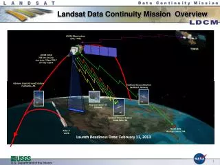
Off-nadir pointing enables imaging of an additional 360,000 square miles of both the Antarctic and Arctic regions
CAPE equipment has all been ordered and deliveries have started Worked through Integration & Test plans with NASA to set up CAPE in the MOC Work continues on schedule for CAPE code and unit test and development integration Completed work to define the DPAS Architecture Baselined the DPAS requirements for the July SRR Managed Integration of TIRS Requirements into the DPAS Baseline Started Scenarios for the DPAS Operational Concept Document, including TIRS Initiated work to define the operations transition roles and responsibilities, as well as the operational structure Significant progress working to mitigate budget shortfall Status Highlights (2 of 2)
Budget Shortfall & Mitigation (1 of 2) Key drivers and circumstances resulting in project shortfall: • Original USGS budget for LDCM based on commercial “data buy”, with flat funding profile • LDCM was later recast to a free-flyer mission from the NPOESS platform • Rigorous latency requirements tied to NPOESS network were transitioned to free-flyer model • Additional scope was required to address new mission definition: • Mission Operations Center and Flight Operations Team • Mission Operations Element • Science Data Scheduling and Acquisition • Ground Network • Addition of the TIRS instrument • Original ground system architecture approach was based on a block replacement every mission
Budget Shortfall & Mitigation (2 of 2) • Budget Shortfall Mitigation • Clear that no “single change” would mitigate the entire budget shortfall • Ground System team identified mitigation options that related to: • Schedule/deliverable delays due to change in launch readiness date • Cost savings & avoidance options • System architecture options • Joint USGS, NASA meeting, Dec 2008, to discuss budget shortfall and mitigation options • Resulted in a joint recommendation to: • Change approach to ground system architecture • Implement a single MOC at GSFC through early operations • Change Flight Operations Team to support a single MOC • Push the staffing curve over by taking advantage of the change in launch readiness date • Additional changes include: • Reducing EROS Center overhead costs • Reducing offsite facility costs • Seeking additional funding • Recommended changes briefed to USGS HQ Geography, Contracts, and Legal • USGS Contractors received new direction Feb 2009
TIRS Strategy • USGS is cautiously taking steps to support TIRS, while it has not yet received funding to support the instrument • Near-Term Purpose & Goals • Identify a TIRS Ground System design approach, which: • Minimizes risk to the mission and launch schedule – focusing on Mission PDR, DPAS PDR, and Ground System PDR • Minimizes the impacts to already approved and funded OLI efforts • Notional Approach & Assumptions • Recognizing that the Ground System's knowledge about the specific TIRS algorithms is limited at the moment, the near-term strategy is primarily tied to algorithm maturity knowledge • Assume instrument scheduling, downlinking, ingesting, archiving mission data, and storing L0Ra data is a given. This is our minimal/basic capability. • Subsequent processing steps, including product generation and distribution, preliminary design to be presented as 'plans' for developing preliminary design and 'impacts' to those parts of the Ground System instead of actual preliminary design. • Our plan is to develop preliminary design for IAS and LPGS, once we have more information about the specific TIRS algorithms at some anticipated date. It is expected that we will have more specific TIRS algorithm knowledge immediately following the Cal/Val TIM in early July.
Algorithm Delivery Status • Total of 45 algorithms to be delivered for implementation to support on-orbit initialization and verification • Ingest • Image Assessment • Product Generation • CalVal Toolkit • An additional 14 algorithms to be implemented by Initial Operations • Algorithms are delivered in phases according to progression in the design and development of OLI instrument and Ground System Image Processing Element (IPE) • Phase 1 – completed for IPE PDR (Oct ’08) • Phase 2 – to be completed by Data Processing & Archive Segment CDR (Jul ’09) • Phase 3 – to be completed by Ground Readiness Tests (GRTs) • Phase 4 – delivered post-launch
Summary • Significant progress has been made on the Ground System • Ground System approach and architecture is now taking advantage of existing capabilities to the extent possible • Ground System preliminary design is underway to accommodate TIRS • Budget shortfall has been mitigated to the greatest extent possible and additional funding has been requested • On track to complete Ground System preliminary design review in September 14