Download
1 / 12
120 likes | 309 Views
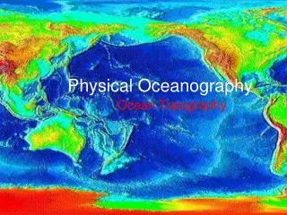
MIG activities and selected results in Physical Oceanography by Juliusz Gajewski, Łukasz Gajewski, Benedykt Hac, Maciej Kałas, Jarosław Nowak, Antoni Staśkiewicz and Kazimierz Szefler Maritime Institute in Gdańsk Długi Targ 41-42, 80-830 Gdańsk im@im.gda.pl. Puck Bay Profiles :

E N D
MIG activities and selected results in Physical Oceanography by Juliusz Gajewski, Łukasz Gajewski, Benedykt Hac, Maciej Kałas, Jarosław Nowak, Antoni Staśkiewicz and Kazimierz Szefler Maritime Institute in Gdańsk Długi Targ 41-42, 80-830 Gdańsk im@im.gda.pl
Puck Bay Profiles: SSS – 22 km
Calibrationfields Profiles: SBES – 73 km SBP & SSS – 37 km Coverage: MBES – 2,1 km2
Słupsk Bank Profiles: MBES – 2340 km SSS & X-Star > 350 km Coverage: 108 km2
Stilo Ustka Profiles: MBES – 3700 km SSS & SBP - > 350 km Coverage: 48,5 km2
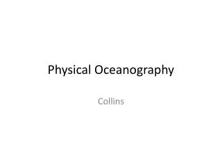
Water temperature, salinity & currents analysis • Bottom layer characteristics from HIROMB model: • Current velocity, cm/s: maximum, average, standard deviation • Water salinity, “psu”: minimum, maximum, average, standard deviation • Water temperature, ºC: minimum, maximum, average, standard deviation – for December-April and June-October periods Nodes of HIROMB model, data from which have been used for analysis of bottom layer temperature, salinity and currents in the Polish EEZ. Data of the period 18.12.2001 – 26.04.2008
Example of results for single grid node EXAMPLE: 18.43028E, 54.74181N (Puck Bay) from the HIROMB model with the resolution of 1 sea mile
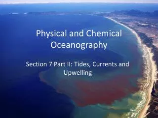
Example of results for single grid node Directional characteristics of currents: Current velocity distribution
Example of results for single grid node Salinity distribution Temperature distribution (average for the entire year)
WAVE PARAMETERS • Wave parameters: • Maximum orbital velocity in the bottom layer • Wave energy potential (in progress) • Data: WAM 4.5 model, resolution 3 sea mile, forecast for the period 2002-2007