Download
1 / 7
70 likes | 256 Views
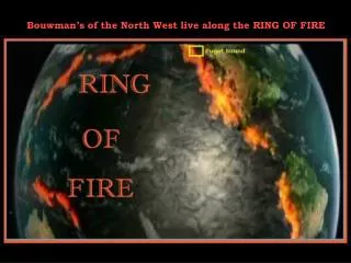
Bouwman’s of the North West live along the RING OF FIRE. I remember the quake of 2001. Working at my computer, I began rolling around in my chair and could not keep my hands on the key board. Friends were skiing on Mt. Rainier. We witnessed Mt. St. Helen’s too.

E N D
I remember the quake of 2001. Working at my computer, I began rolling around in my chair and could not keep my hands on the key board. Friends were skiing on Mt. Rainier We witnessed Mt. St. Helen’s too. The quakes shown in 2010 are just those in one week. They are not unusual as the Pacific Plate moves in under us.
Red Arrows Show how earth plates move. Now this is where more quakes - - > are experienced. I was in the 1989 quake, working in Concord.
This displays how the Pacific Plate is fractured. The Subduction Zone is where it moves in under us.
The mantle under the ocean slides down and under the continent. Loose gases and lava break away at times to work their way up through the mantles to create volcanos The red areas simulate earth quakes as the mantle flow encounters resistance. The quakes occure at deeper locations as they move under the continent.
The American continent is widening a few centimenters every year. Stations are located at places best to records quake data. Tiger Mountain is east of Seattle on the south side of I-90 These stations have GPS locating devices that display the change in global position and the stations are moving.
I found this information on the history channel in February of 2010 Added information was found on Google Earth