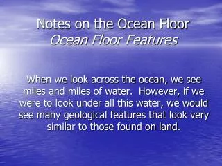
Ocean Features
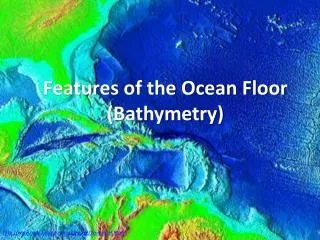
Ocean Features. Bathymetry. Bathymetry -(Bathos=depth;metry-measurement) Measurement of ocean depths and charting the shape of the ocean floor Sounding - Using a line with heavy weight to probe ocean’s depths


Ocean Features
E N D
Presentation Transcript
Bathymetry • Bathymetry-(Bathos=depth;metry-measurement) Measurement of ocean depths and charting the shape of the ocean floor • Sounding- Using a line with heavy weight to probe ocean’s depths • Fathom- unit of measurement specifically for ocean depth measurement (1 fathom=1.8 meters=6 feet)
HMS Challenger • 1872- made first systematic measurements using sounding technology • Noticed that depth varied indicating that the ocean floor was not flat, but had relief just as land does
Advancing Technology • SONAR Technology- Sound, Navigation, And Range • 1900s- Echo Sounders • Sends a sound signal to determine depth and shape of ocean floor. Early technology not very accurate • 1950s- Precision Depth Recorder (PDR) • Used high-frequency sound beam to measure depths within 1 meter accuracy • Current technology- Multibeam Echo Sounders • Use multiple frequencies of sound simultaneously giving more precise data • http://player.discoveryeducation.com/index.cfm?guidAssetId=933F96EA-3524-4872-9335-94E264BD51C4
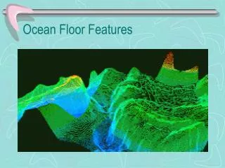
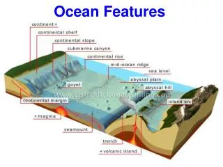
Ocean Floor Provinces • Continental Margins • Shallow water areas close to continents • Deep Ocean Basins • Deep water areas farther from land • Mid-Ocean Ridge • Shallower areas near the middle of the ocean
Continental Margins • Passive Margins • Imbedded within the interior of lithospheric plates and are not in close proximity to plate margins • Lack tectonic activity • Active Margins • Associated with lithospheric plate boundaries and are marked by a high degree of tectonic activity
Active Margins • Convergent Active margins • oceanic-continental convergent plate boundaries • Features • Continental arc, narrow shelf, steep slope, offshore trench • Transform Active margins • Transform plate boundaries • Faults create linear islands, banks, deep basins
Features of Continental Margins • Continental shelf- flat zone extending from the shore beneath the ocean to a point where slope angle increases dramatically • Average width- 70 KM • Ranges from a meters to 1500 KM • Shelf Break- Point where increase in slope angle occurs • Can contain coastal islands, reefs, and raised banks
Features of Continental Margins • Continental borderland- occurs in faulted areas (California). High degree of relief on shelf • Continental slope- this is where deep ocean basins begin • Continental rise- transition zone between the continental margin and the deep ocean floor • Graded bedding, produced by turbidity currents. Layered sedimentation with heavier sediments settling out first. Decrease in sediment size from bottom to top
Underwater Canyons • Submarine canyons- V-shaped and have branches or tributaries with steep overhanging walls • Thought to occur because of turbidity currents • Turbidity currents- Underwater avalanches of muddy water mixed with rocks and other debris • Mass moves from earthquakes, hurricanes, or other disturbance carving the canyon
Deep Ocean • Abyssal Plains- Extend from the base of the continental rise into the deep-ocean basins. • Flat, depositional surfaces with very slight slopes • Average between 4500 meters and 6000 meters deep • Suspension Settling- fine particles of sediment slowly drift onto the deep ocean floor • This is how abyssal plains form
Underwater Volcanoes • Seamounts: Below sea level, but rise 1 kilometer above the deep ocean floor • Seaknolls (abyssal hills) less than 1 kilometer above the deep ocean floor
Ocean Trenches • Deep linear scars in the ocean floor. They are very narrow and steep • Occurs along active continental margins, where there is a convergent plate boundary • The side nearest to land can be volcanic arcs (islands of Japan), or continental arcs (Andes Mountains)
Mid-Ocean Ridge • Earth’s longest mountain chain – 75,000 kilometers/46,600 miles • Divergent boundary • Entirely volcanic- composed of basaltic lavas • Rift valley occurs along its crest • Underwater lava flows- Pillow lavas
Hydrothermal Vents • Hot springs which occur in the central rift valley • Appearance depends on temperature of water • Warm-water vents are below 30oC (86oF) and are clear in color • White smokers are between 30oC and 350oC (86oF- 662oF) and are white in color • Black smokers are above 350oC (662oF) and are black in color
Mid-Ocean Ridge cont. • Oceanic ridges have a rift valley and steep rugged slopes • Oceanic rises have slopes that are gentler and less rugged
Mid-Ocean Ridge • Transform Faults cut the mid-ocean ridge in a number of places • These faults are perpendicular to the mid-ocean ridge and give the ridge a zigzag appearance • Many earthquakes occur here • Fracture Zones also extend from the mid-ocean ridge, but are much different from transform faults