Download
1 / 1
10 likes | 180 Views
Source Water Protection Tools Roger Anzzolin (EPA OGWDW), William Cooter, James Rineer, Sunil Rao, Kevin Pickren, and Michael Bacon (RTI International). Overview

E N D
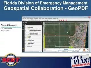
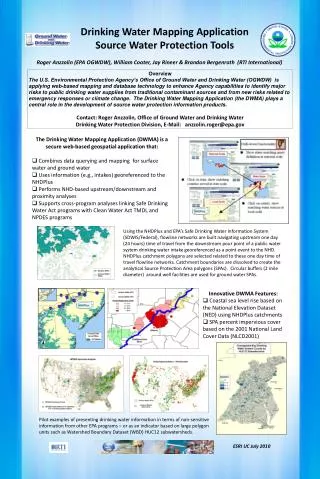
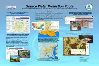
Source Water Protection Tools Roger Anzzolin (EPA OGWDW), William Cooter, James Rineer, Sunil Rao, Kevin Pickren, and Michael Bacon (RTI International) Overview The U.S. Environmental Protection Agency’s (EPA’s) Office of Ground Water and Drinking Water (OGWDW) is applying state-of-the-art, web-based mapping and database technology to enhance Agency capabilities to identify major contaminant risks to public drinking water supplies and underground sources of drinking water. Features from ongoing projects are highlighted that show approaches for integrating vector, raster and remote sensing data with Area of Investigation (AOI) data mining services for use in web-based applications. Leveraging Drinking Water Mapping Application Content & Design Approaches New address matching and remote sensing services have clear immediate value for site investigation and locational improvement functions Pattern recognition tools to automate the extraction of information on CAFO locations from high resolution aerial photography images – an example from Duplin County, NC • The Drinking Water Mapping Application (DWMA) is a secure web-based geospatial application that: • Combines data querying and mapping for surface water and ground water • Uses information (e.g., intakes) georeferenced to the NHD • Performs NHD-based upstream/downstream and proximity analyses • Uses Area of Investigation data mining tools to process both vector data (e.g, for regulated facilities) and raster data • Supports cross-program analyses linking Safe Drinking Water Act programs with Water Quality Standards, TMDL and NPDES programs in the Office of Water and with Underground Storage Tank program in the Office of Underground Storage Tanks • Provides functionality that can be generalized to create new data mining and AOI services New Area of Investigation (AOI) data mining tools linking raster data (NOAA topographic-bathymetric layers) with NHDPlus catchment polygons for a hypothetical 10 meter surge zone in Gulf coastal areas around New Orleans. For more information Roger Anzzolin U.S. Environmental Protection Agency Office of Ground Water and Drinking Water Drinking Water Protection Division 1200 Pennsylvania Ave. NW Washington, DC 20460-0001 E-Mail: anzzolin.roger@epa.gov Corridor tool services for the analysis of contaminant risk factors for source protection areas along AOIs for arterial roads.