Download
1 / 6
70 likes | 194 Views
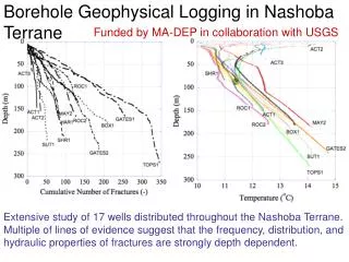
Borehole Geophysical Logging in Nashoba Terrane. Funded by MA-DEP in collaboration with USGS.

E N D
Borehole Geophysical Logging in Nashoba Terrane Funded by MA-DEP in collaboration with USGS Extensive study of 17 wells distributed throughout the Nashoba Terrane. Multiple of lines of evidence suggest that the frequency, distribution, and hydraulic properties of fractures are strongly depth dependent.
All measures of fracture distributions and numbers show downward decreasing trends with depth Measures of hydraulically active fractures also show decreasing trends with depth and cease below ~165 m
Fracture Permeability with Depth Pending Proposal with NSF-Hydrologic Sciences Proposed Work: Evaluate the depth evolution of fracture permeability in distinct rock types characterized by (a) massive fractured rock, (b) steeply dipping foliation, and c) shallow dipping foliation. 1) At selected sites with > 150 m boreholes we will perform straddle packer slug tests in fractures that characterize distinct sets and types 2) Deploy newly acquired fiber optic-based distributed temperature system in each well and use to compare to straddle packing tests
Fracture Permeability with Depth Pending Proposal with NSF-Hydrologic Sciences Site map with proposed study locations and previous data collection efforts
Factors controlling Recharge in New England Fractured Rock Terrain Funded Proposal with NIWR - 104G Proposed Work: Building upon the USGS 2004 study by DeSimone of the hydrology of the Assabet River Watershed we intend to examine the fate of recharge water into shallow till and bedrock and to quantify at a number of sites the degree of hydraulic connection between them 1) At selected sites that meet our specifiic criteria (till covered, close to pre-existing data collection sites, and in a predicted recharge area by DeSimone (2004)). We will heavily instrument multi-level till and bedrock wells for long term (~2 yrs+) monitoring for heads, geochemistry, etc. 2) Analysis physical and geochemical data for estimates of Recharge and its distribution across the till-bedrock interface.
Factors controlling Recharge in New England Fractured Rock Terrain Funded Proposal with NIWR - 104G Site maps with political boundaries, subcrop location of Nashoba Formation and previous data collection efforts by OSG and USGS