Download

1 / 44
440 likes | 458 Views
Explore the mechanisms driving atmospheric and ocean circulation worldwide and the impact of temperature, humidity, and pressure. Learn about seasonal variability and the Coriolis force's influence on motion.

E N D
lecture 4 Atmosphere and Ocean Circulation
The global atmospheric circulation and its seasonal variability is driven by the uneven solar heating of the earth’s surface.
Because earth’s rotation axis is tilted relative to the plane of its orbit around the sun, there is seasonal variability in the geographical distribution of sunshine. March December June September
The geographical distribution of temperature and its seasonal variability closely follows the geographical distribution of sunshine.
Temperature plays a direct role in determining the climate of every region. Temperature differences are also key in driving the global atmospheric circulation. Warm air tends to rise because it is light, while cold air tends to sink because it is dense. As we will see, this sets the atmosphere in motion.
As air becomes cooler, its capacity to hold water in vapor form decreases significantly. This is known as the Clausius-Clapeyron relationship. This means that if air containing water vapor cools down, it will eventually become saturated with water vapor. As the air cools further, enough water vapor condenses into droplets to maintain the air at its saturation point.
Measurements of water vapor in the atmosphere at Black Rock Forest during the early fall of 1995. The saturation curve of water vapor is clearly evident. Graphic courtesy of John Knox
The Clausius-Clapeyron relationship leads us to the concept of relative humidity. Relative humidity is defined as the ratio of the amount of water vapor in the air to the amount of water vapor that air would hold if it were saturated. So completely saturated air has a relative humidity of 100%. If the air has half as much water vapor as it can hold, the relative humidity is 50%.
In the lowest 10 km of the atmosphere, temperature decreases with height. So when warm air rises from the surface, it cools. Because of the Clausius-Clapeyron relationship, this often means that the air is quickly brought to saturation. Condensation begins, and clouds form. If the air is especially buoyant, condensation continues, causing the water droplets to increase in size. Eventually the water droplets are so large they begin to coalesce and fall as precipitation. For this reason, rising motion is often associated with precipitation.
Temperature differences are key in driving the global atmospheric circulation. Warm air tends to rise because it is light, while cold air tends to sink because it is dense. This sets the atmosphere in motion. The tropical circulation is a good example of this.
In addition to understanding how temperature affects the atmospheric circulation, we also need to understand one of the basic forces governing air and water motion on earth: The Coriolis Force. But to understand this effect, we first need to review the concept of angular momentum conservation.
Angular momentum conservation means that if a rotating object moves closer to its axis of rotation, it must speed up to conserve angular momentum. Conversely, as a rotating object moves further from its axis of rotation, it must slow down.
The earth’s curved surface means that objects are moving at very different speeds depending on their latitude: At the equator (latitude 0°), an object is moving at a speed of about 1700 km/hr. At the pole (latitude 90°), an object moving hardly at all due to the earth’s rotation. Here in Los Angeles (latitude 34°N), an object is moving at a speed of about 1400 km/hr (=860 miles/hr!).
If an initially motionless object moves from the equator northward, it will move closer to the earth’s axis of rotation, and will have to acquire speed in the direction of the earth’s rotation. This results in an apparent deflection to the right. Similarly, an initially motionless object at the equator moving southward into the southern hemisphere will undergo an apparent deflection to the left.
It turns out that all objects moving in the northern hemisphere are deflected to the right by the Coriolis force, while all objects moving in the southern hemisphere are deflected to the left. It is easy to see how this can result in curved trajectories of objects moving on the earth’s surface.
PRESSURE Air is not evenly distributed on the earth’s surface. In areas where there is less air, pressure at the surface is low, while in areas where there is more air, pressure at the surface is high. Air moves from regions of high to low pressure to even out the distribution. However, as air moves towards low pressure, it comes under the influence of the Coriolis Force.
Hurricane Katrina 2005 Air moving toward low pressure at the center of the hurricane is deflected to the right, resulting in a spiral trajectory of air toward the hurricane’s center. This is visible in the clouds generated by the storm.
Climatological surface winds are organized by zones of high and low pressure. Note the subtropical high pressure zones over ocean basins stemming from relatively cool temperatures there.
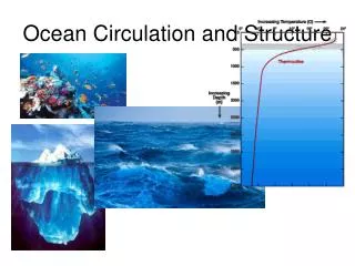
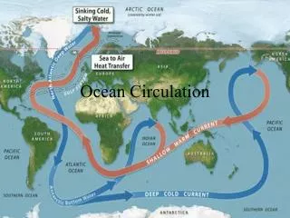
The ocean circulation is driven by the transfer of heat, water, and momentum across the air-sea interface. Heat transfer is accomplished through (1) latent heat flux, (2) sensible heat flux and (3) radiation. Water transfer is accomplished through evaporation and precipitation. And momentum transfer takes place through the frictional effects of winds on the ocean surface. lecture 6 Ocean Circulation
Temperature, salinity, and density are the key variables describing the state of the ocean. Density is a function of both temperature and salinity. As water warms, it expands and becomes less dense. Dissolved salts are heavier than water, so density increases with salinity.
Unlike the atmosphere, the ocean is heated from above. Therefore, the warmest temperatures are at the surface of the ocean. Because warmer water is lighter, this creates a stable environment, with little vertical motion. This is why the deep circulation of the ocean is so sluggish compared to the atmosphere.
Vertical distribution of temperature, salinity, and density depth (m)
sea surface salinity climatology Salinity is measured in parts per thousand
The surface ocean circulation is organized into gyres, which rotate clockwise in the northern hemisphere, and counterclockwise in the southern hemisphere.
The ocean is set in motion by the atmosphere. Surface winds generate ocean currents. To see how this occurs, we first need to understand the concept ofEkman drift.
Ekman driftrefers to the mechanical response of the ocean to wind blowing across its surface. The surface water is dragged along with the wind. However, due to the Coriolis force, it is deflected somewhat to the right (in the NH). The surface water drags along the water immediately beneath it but at a somewhat slower speed, and this layer is also deflected to the right under the influence of the Coriolis force. The result is a spiraling pattern in the current direction with ever decreasing current speeds with depth.The net transport of water is to the right of the wind.
Climatological surface winds are organized by zones of high and low pressure. Note the subtropical high pressure zones over ocean basins stemming from relatively cool temperatures there.
Because the ocean is typically cooler than land in the subtropics, the air over the subtropical ocean is denser than over land. This means that pressure is high over the subtropical ocean. Because of the Coriolis effect, high pressure means that in the subtropics, air is circulating clockwise over northern hemisphere ocean basins, and counterclockwise over southern hemisphere ocean basins.
Through the Ekman mechanism, the clockwise atmospheric flow (in the northern hemisphere) creates a pile-up of water in the middle of the ocean basin. One effects of this pile-up or convergence of water is downwelling (downward movement of water) in the middle of the subtropical oceans.
Another effect is that seawater tries to flow down the “hill” of water in the middle of the basin. As it does, the Coriolis force deflects it to the right. This is what generates the clockwise circulation or gyre.
The surface ocean circulation is organized into gyres, which rotate clockwise in the northern hemisphere, and counterclockwise in the southern hemisphere.
An example of gyre flow at the western boundary of the Atlantic: The Gulf Stream
The Ekman mechanism is also responsible for coastal upwelling and downwelling. In the northern hemisphere, if one is moving with the wind and the coast is on the left, water will be transported away from the coast by the Ekman mechanism. Deep water will be pulled up to compensate for the lost surface water at the coast (upwelling). If one is moving with the wind and the coast is on the right, water is transported toward the coast and the surface waters are driven downward (downwelling). One can often see evidence of upwelling and downwelling by examining sea surface temperatures.
One area where upwelling often occurs is off the coast of California. This satellite image shows cold temperatures all along the California coast, indicating that deep cold water is being pulled to the surface. In what direction are the winds blowing?
The Ekman mechanism also drives Equatorial Upwelling. Recall that near the equator, trade winds blow toward the west. These winds transport water poleward in both hemispheres, forcing cold deeper waters to the surface at the equator. It turns out that deep waters are very rich in nutrients. For this reason, zones of upwelling can be very clearly seen from satellite images of chlorophyll, the chemical that makes plants green.