Download
1 / 6
60 likes | 220 Views
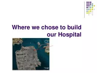
Where we chose to build our Hospital. Location .

E N D
Location • The site we have chosen is situated north east of the centre of San Francisco. It is situated in Western Addition and is in an open space between Fulton Street, Hayes Street, Scott Street and Steiner Street. The site is currently called Alamo Square. It is approximately 265.41m by 181.91m. The land is fairly steep but it should be ok. The land is in a blue area which means that it has low shaking amplification. We want to build it away from shaking ground so it wouldn’t collapse during an earthquake. It is away from any fault lines, this is good because there would be less vibrations through the earth so the earthquake would not be as violent as if it was near a fault line.
Population and Household income. • By using the population density maps we have found that the population is around 34001 to 59000 residents per square mile. We wanted to built our hospital near lots of people because then more people would benefit from the build of this hospital. The average household income of this area is -$12,000 to -$2,001. By using the household income maps this is shown by being coloured light red. We wanted to build a hospital near a poorer community because there is more chance that their houses would be damaged in the event of an earthquake. Our hospital is near several schools and a fire station.
Population and Household income maps Population Household income
Seismic hazards and Bay area faults • By using the Seismic hazard maps we have realised that our site is quite far away from the liquefaction sites. This is shown on the maps as green splodges and means that the area won’t turn to liquid during an earthquake. Our site is also far away from earthquake-induced landslides. This is shown on the map as blue splodges, this means that the area will not be likely to get a landslide. We also used the bay area faults maps to see if it was close to any fault lines. The nearest fault line was 11,600.36m away.
Seismic hazard and Bay fault line maps This is the distance between our site and the nearest fault line This is where we would put a hospital