Google Maps API
Google Maps API. L. Grewe. Google Maps. Largest Mapping API One of the most popular web services Used in many web “ mashup ” applications Used on many platforms – also in mobile devices. Google Maps API. Google Maps API - javascript. Multiple Possibilities Maps JavaScript API


Google Maps API
E N D
Presentation Transcript
Google Maps API L. Grewe
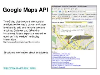
Google Maps • Largest Mapping API • One of the most popular web services • Used in many web “mashup” applications • Used on many platforms – also in mobile devices
Google Maps API -javascript • Multiple Possibilities • Maps JavaScript API (http://code.google.com/apis/maps/documentation/javascript/ ) • Static Maps API (http://code.google.com/apis/maps/documentation/staticmaps/ ) • Maps API for Flash • Google Earth (3d) API (http://code.google.com/apis/earth/)
Features of Maps API • Keyless • Designed for multiple platforms including mobile • Styled Maps • Markers • Polygons/Polylines • Geocoding/Driving Directions • Elecvation • Fusion Tables integration
Static Maps • Have no dynamic component but, will display a location – useful for showing where a fixed location is (location of company, etc). • EXAMPLE – Sao Paulo, Brazil with size and zoom given • http://maps.google.com/maps/api/staticmap?sensor=false&size=500x300&zoom=9¢er=Sao+Paulo+Brazil
Stylized Static Maps Append Style information to URL of static map (same location as previous) http://maps.google.com/maps/api/staticmap?sensor=false&size=500x300&zoom=9¢er=Sao+Paulo+Brazil&style=feature:water|saturation:100|hue:0xff5e00|gamma:0.58&style=feature:landscape|invert_lightness:true&style=element:labels|visibility:off&style=feature:poi|hue:0x0800ff|lightness:-70&style=feature:administrative|element:geometry|visibility:off
Dynamic Maps with Google JavaScript Map API Hello World Example <!DOCTYPE html><html><head><meta name="viewport" content="initial-scale=1.0, user-scalable=no" /><style type="text/css"> html { height: 100% } body { height: 100%; margin: 0px; padding: 0px } #map_canvas { height: 100% }</style><script type="text/javascript"src="http://maps.google.com/maps/api/js?sensor=set_to_true_or_false"></script><script type="text/javascript">function initialize() {varlatlng = new google.maps.LatLng(-34.397, 150.644);varmyOptions = { zoom: 8, center: latlng,mapTypeId: google.maps.MapTypeId.ROADMAP };var map = new google.maps.Map(document.getElementById("map_canvas"),myOptions); }</script></head><body onload="initialize()"> <div id="map_canvas" style="width:100%; height:100%"></div></body></html>
HelloWorld Map explained Create new instanceof LatLng object function initialize() {varlatlng = new google.maps.LatLng(-34.397, 150.644);varmyOptions = { zoom: 8, center: latlng,mapTypeId: google.maps.MapTypeId.ROADMAP };var map = new google.maps.Map(document.getElementById("map_canvas"),myOptions); } Setup Options for map will create Create new instance of a Google Map with our options and associated with a div tag in our html body
HelloWorld Map example • See course website for other examples • http://www.mcs.csueastbay.edu/~grewe/CS2020/Mat/Maps/HelloWorldMap.htm
Markers Markers are like map pins showing the location of places of interest in your map. var map;function initialize() {varmyLatlng = new google.maps.LatLng(-25.363882,131.044922);varmyOptions = { zoom: 4, center: myLatlng,mapTypeId: google.maps.MapTypeId.ROADMAP } map = new google.maps.Map(document.getElementById("map_canvas"), myOptions);var marker = new google.maps.Marker({ position: myLatlng, map: map, title:"Hello World!" });}
Markers example • See course website for examples and more details on markers • http://www.mcs.csueastbay.edu/~grewe/CS2020/Mat/Maps/Example_Map_Marker.htm
Markers Example with Events – open an InfoWindow (bubble) varmyLatlng = new google.maps.LatLng(-25.363882,131.044922); varmyOptions = { zoom: 4, center: myLatlng, mapTypeId: google.maps.MapTypeId.ROADMAP } var map = new google.maps.Map(document.getElementById("map_canvas"), myOptions); varcontentString = '<div id="content">'+ '<div id="siteNotice">'+ '</div>'+ '<h1 id="firstHeading" class="firstHeading">Uluru</h1>'+ '<div id="bodyContent">'+ '<p><b>Uluru</b>, also referred to as <b>Ayers Rock</b>, is a large ' + 'sandstone rock formation in the southern part of the '+ 'Northern Territory, central Australia. It lies 335 km (208 mi) '+ 'south west of the nearest large town, Alice Springs; 450 km '+ '(280 mi) by road. KataTjuta and Uluru are the two major '+ 'features of the Uluru - KataTjuta National Park. Uluru is '+ 'sacred to the Pitjantjatjara and Yankunytjatjara, the '+ 'Aboriginal people of the area. It has many springs, waterholes, '+ 'rock caves and ancient paintings. Uluru is listed as a World '+ 'Heritage Site.</p>'+ '<p>Attribution: Uluru, <a href="http://en.wikipedia.org/w/index.php?title=Uluru&oldid=297882194">'+ 'http://en.wikipedia.org/w/index.php?title=Uluru</a> (last visited June 22, 2009).</p>'+ '</div>'+ '</div>'; varinfowindow = new google.maps.InfoWindow({ content: contentString }); var marker = new google.maps.Marker({ position: myLatlng, map: map, title:"Uluru (Ayers Rock)" }); google.maps.event.addListener(marker, 'click', function() { infowindow.open(map,marker); }); Create Map String to be content to be in “bubble” overlay (InfoWindow) that will be displayed (opened) when user clicks on a marker Create “bubble” InfoWindow Create Marker Add Event Listner – when user clicks on marker openthe InfoWindow (“bubble”)
Markers Example with Events – open an InfoWindow (bubble) • Try it at: http://www.mcs.csueastbay.edu/~grewe/CS2020/Mat/Maps/Example_Map_Marker_InfoWindowOverlay.htm
Stylized Maps • Control look of maps • Change size, color, and visibility of • Points of Interest • Labels • Roads • Water • Borders • and more • Clean up interface • Match the color scheme of your site • Be artistic
Example Stylized Maps from Google • Black with no roads, http://manomarks.net/stylemap2.html
Code <!DOCTYPE html> <html> <head> <link href="http://code.google.com/apis/maps/documentation/javascript/examples/standard.css" rel="stylesheet" type="text/css" /> <script type="text/javascript" src="http://maps.google.com/maps/api/js?sensor=false"></script> <script> var map; varmunich = new google.maps.LatLng(48.198238,11.610663); var MY_MAPTYPE_ID = 'noroads'; f unction initialize() { varstylez = [ { featureType: "road", elementType: "all", stylers: [ { visibility: "off" } ] }, { featureType: "poi", elementType: "all", stylers: [ { visibility: "off" } ] }, { featureType: "water", elementType: "all", stylers: [ { saturation: -100 }, { lightness: -100 }, { gamma: 8.79 } ] } ]; varmapOptions = { zoom: 12, center:munich, mapTypeControlOptions: { mapTypeIds: [google.maps.MapTypeId.ROADMAP, MY_MAPTYPE_ID] }, mapTypeId: MY_MAPTYPE_ID }; map = new google.maps.Map(document.getElementById("map_canvas"), mapOptions); varstyledMapOptions = { name: "No Roads" }; varnrMapType = new google.maps.StyledMapType(stylez, styledMapOptions); map.mapTypes.set(MY_MAPTYPE_ID, nrMapType); } </script> </head> <body onload="initialize()"> <div id="map_canvas" style="width:full; height:100%"></div> </body> </html>
Example Stylized Maps from Google • Land and Water only http://gmaps-samples-v3.googlecode.com/svn/trunk/styledmaps/examples/style2.html
code <html> <head> <title>Styles</title> <script type="text/javascript" src="http://maps.google.com/maps/api/js?sensor=false"></script> < script type="text/javascript"> var maps; vargeocoder; function init() { var styles = { 'Dark': [ { featureType: "all", elementType: "all", stylers: [ { invert_lightness: true } ] },{ featureType: "administrative", elementType: "labels", stylers: [ { visibility: "off" } ] },{ featureType: "landscape", elementType: "all", stylers: [ { visibility: "off" } ] },{ featureType: "poi", elementType: "all", stylers: [ { visibility: "off" } ] },{ featureType: "road", elementType: "all", stylers: [ { visibility: "off" } ] },{ featureType: "transit", elementType: "all", stylers: [ { visibility: "off" } ] },{ featureType: "water", elementType: "labels", stylers: [ { visibility: "off" } ] },{ featureType: "water", elementType: "geometry", stylers: [ { lightness: 50 } ] } ] }; for (var s in styles) { var opt = { mapTypeControlOptions: { mapTypeIds: [s] }, disableDefaultUI: true, navigationControl: true, center: new google.maps.LatLng(37.7749295, -122.4194155), zoom: 8, mapTypeId: s }; var div = document.getElementById('map'); var map = new google.maps.Map(div, opt); varstyledMapType = new google.maps.StyledMapType(styles[s], {name: s}); map.mapTypes.set(s, styledMapType); } } </script> <style> body { margin: 0px; padding: 0px; } #map { width: 500px; height: 180px; border: 1px solid black; margin: 0px; padding: 0px; } </style> </head> <body onload="init()" id="body"> <div id="map"></div> </body> </html>
Fusion Tables • What are they • How to create and use
Google Maps – Fusion Tables • Data management web application allowing easy host, manage, collaboration on, visualization and publishing of data tables online
Fusion Tables –uploading data • Connect to google and go to fusion tables • Public files can be seen by all. • You can have your own tables
Fusion Tables - visualization • Tools lets you “see” / visualize data
Fusion Table Layer JavaScript code: layer = new google.maps.FusionTablesLayer (someid, { query: “SELECT address FROM someidWHERE ridership > 5000”} ); Layer.setMap(map);
Fusion Tables Demos from Google • Bounding Box search http://gmaps-samples.googlecode.com/svn/trunk/fusiontables/rectangle_example.html
Fusion Tables Demos from Google • Radius Search http://gmaps-samples.googlecode.com/svn/trunk/fusiontables/circle_example.html
Fusion Tables Demos from Google • Congressional Areas http://www.google.com/fusiontables/DataSource?dsrcid=290985
Google Latitude • A mobile app that lets you see where your friends are on a map and share your Real location with whomever you choose. • Location continuously & automatically updated • Add friends with whom you share location • Share best available or city-level location • Change privacy settings at any time • Android, BlackBerry, Symbian, Windows Mobile, or • iPhone* • 29 countries, 42 languages • 8 million+ accounts created & 3 million+ active users
Google Latitude API • Use features of Google Latitude in your app • A simple and secure way for users to use their location in new ways by sharing it with 3rd party developers, apps, and services in addition to their friends. • Why use the Latitude API? • What would you offer your users if they shared their real location with you? • Latitude pushes users’ real location to the cloud so any service – mobile or desktop – can leverage it for location-based features without building a mobile app. • Create smarter features based on users’ location history if enabled