Download
1 / 41
410 likes | 430 Views
Evaluating precision gain for timber and non-timber attributes via Landsat-based stratification on California’s North Coast. Antti Kaartinen, Jeremy Fried & Paul Dunham. Other collaborators: Michael Lefsky, Dale Weyermann Dave Azuma. Portland. Why stratify?.

E N D
Evaluating precision gain for timber and non-timber attributes via Landsat-based stratification on California’s North Coast Antti Kaartinen, Jeremy Fried & Paul Dunham Other collaborators: Michael Lefsky, Dale Weyermann Dave Azuma Portland
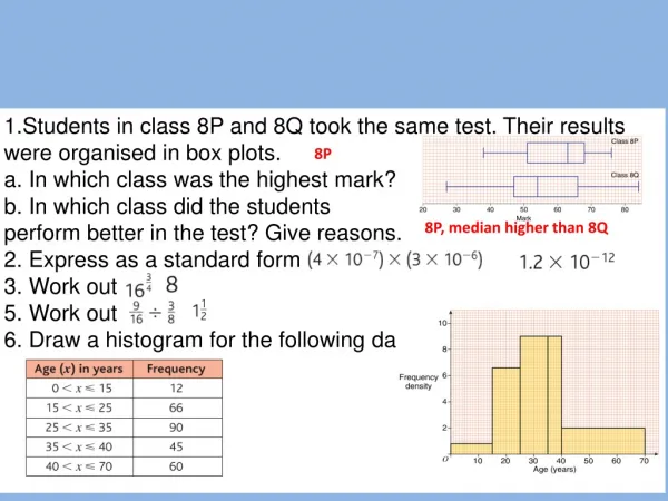
Why stratify? Increase precision of inventory estimates by reducing sampling error (std err of estimate/estimate). How does it work? • Divides area “population” into strata such that: • variability of plots within strata < variability of plots within the population as a whole, and • Strata with high variability make up a relatively small proportion of the population. • Then, sample from the strata using stratified random sampling or double-sampling
Standards of precision • Forest Survey Handbook reliability standards: • Timberland area: 3% sampling error per million acres • Growing stock volume: 10% sampling error per billion cu ft • Where sampling error = std error / estimate • Are these standards or targets?
Two-phase sampling • Phase 1 • Collect data for stratification • Photo-interpretation for Forest Land Strata (FLS) • Phase 2 • 1/16 of Phase 1 plots are designated field plots • Install/measure field plots • Efficient strategy for sampling error reduction, but • Phase 1 not really cheap • ~$2 million for CA, OR, WA
Why evaluate more automated methods? • Save time and money? • Responsive to national mandate! • Standardization could facilitate interpretation • Timely- several PIs now 20 years old • How current does Phase 1 need to be?
How does FIA stratify elsewhere? • Photo-interpretation (PI) in most areas • North Central: NLCD + Edge classes • Rocky Mountain: AVHRR • Northeast: NLCD+5X5 pixel moving window filter
PNW’s Stratification Testing • Tested 3 LANDSAT-TM based stratification methods • Compared with PI & Simple Random Sampling • Location criterion: availability of recent PI • Assembled multi-institutional strike team: Antti Kaartinen, Helsinki University Michael Lefsky, Oregon State University Dale Weyermann, PNW-FIA, Inv. Reporting & Mapping Paul Dunham, PNW-FIA, Inv. Reporting & Mapping Jeremy Fried, PNW-FIA, Environmental Analysis & Research Dave Azuma, PNW-FIA, Environmental Analysis & Research
Stratification sources- all based on TM • Existing GIS layers • NLCD • CALVEG • Customized system for generating a new GIS layer • FIASCO-TM
NLCD:National Land Cover Dataset • Developed at EROS from LANDSAT 5 TM imagery circa 1992 by MRLC • Covers lower 48 states • Used leaf on/off imagery • Built on unsupervised classification, census & National Wetlands Inventory data, and digital terrain models • Intended update cycle is 5-10 years
CALVEG:Classification and Assessment with Landsat of Visible Ecological Groupings • Developed by USFS R5 RSL, Sacramento & CDF • LANDSAT-TM data used for life form • Other inputs vary by location and include • Field observations • DEMs • Local knowledge • Classified polygons include life form, tree cover species and stage of stand development
FIASCO-TM: Forest Inventory and Analysis Stratification with Classification of Thematic Mapper • Developed in cooperation with Michael Lefsky, Oregon State University Dept of Forest Science • TM scenes trained by a 20% intensity phase 1 PI • Semi-automated, supervised classification • Uses spectral signature of pixels overlaying a PI point as a basis for classifying other pixels • Produces a map of Forest Land Strata (FLS)
How the class definitions affect the resulting classified image
Image Processing • Reprojection • Masking • Image correction • Image mosaic
Landsat scenes from raw images to georeferenced and normalized mosaic
Image Processing • Reprojection • Masking • Image correction • Image mosaic • Classify/Recode
Stratification crosswalks Forest/nonforest (fnf) fnf + other forest (fofnf) Deciduous, evergreen, mixed, other forest, non-forest (DEMON) Forest Deciduous Forest Evergreen Forest Mixed Forest Other forest Bare/transitional Shrubland Woody wetland Nonforest Everything else Recode/cross-walk: NLCD
9 cover types Several stand size class, density and species attributes; 100s of combinations Ultimately aggregated to eight strata Constructed strata non-stocked hardwood low-volume conifer medium-volume conifer high-volume conifer other-forest non-forest unclassified Recode/cross-walk: CALVEG
Image Processing • Reprojection • Masking • Image correction • Image mosaic • Classify/Recode • Post-processing • Filtering via clump & sieve
Steps in filtering a classified image file Original classified image After clump & sieve Clumps of pixels, that were Smaller than the threshold Value (4 pixels) are removed After neighborhood analysis Majority function in 3*3 pixel window defines a new value for Each ‘empty’ cell Evergreen & mixed forest Nonstocked forest Deciduous forest 30-METER PIXELS Nonproductive forest Nonforest
Image Processing • Reprojection • Masking • Image correction • Image mosaic • Classify/Recode • Post-processing • Filtering via clump & sieve • Edge class generation
Edge classes • Edges created around every type • Addresses issues of misregistration-induced incorrect assignments of plots to strata • Such incorrectly assigned plots comprise a smaller strata, thus having less impact on overall variance • Experimented with edge widths of 2-4 pixels • Edge class effectiveness explored for each data source
Forest / Nonforest with 4-pixel edge strata Forest Forest Edge Non Forest Non Forest Edge
DEMON with 4-pixel strata Evergreen Forest Evergreen Forest Edge Deciduous Forest Deciduous Forest Edge Other Forest Other Forest Edge Non Forest Non Forest Edge Mixed Forest & Mixed Forest Edge
Table Generation • Population estimates & sampling errors for • Timberland area • Timberland growing stock volume • Coarse woody debris volume • Area of vegetation cover classes • Processed via SAS scripts designed to handle • Double sampling • Stratified random sampling • Simple random sampling • Also conventional PI and random (no Phase 1)
Variance with stratification Variance with simple random sampling Design effect k= Relative confidence intervals at different levels of statistical efficiency moderate minimal substantial excellent k=0.25 k=0.50 k=0.67 k=0.83 k=1 after Särndal et al. 1992
Timberland area Sampling error per 1 million acres
Volume on timberland Sampling error per 1 billion cubic feet
Coarse Woody Debris Sampling error per 1 billion cubic feet
Understory vegetation cover classes Class 1: (0% shrub cover) Class 2: (0 – 40 % shrub cover) Class 3: ( >= 40 % shrub cover)
Generally high precision Opportunities for ancillary studies Easy to fine tune For areas of interest To fit FIA definitions Opportunities for year-round employment of some data collection staff PI- advantages
Could standardize in lower 48 Development costs shared among agencies Pre-rectified/classified imagery huge savings Precision nearly as good as PI for this study area NLCD - advantages
Easily fine tuned to local conditions/needs Current version gives good precision; may be amenable to improvement Generates a wall-to-wall FLS map which may be useful to some clients FIASCO-TM - advantages
Polygons have many attributes, facilitating customization Data may be useful for other purposes Precision performance good CALVEG - advantages
Caveats • Cost comparisons don’t consider • value of maps produced incidental to the stratification • capacity to conduct ancillary studies • self-sufficiency wrt phase 1 production • We don’t yet know true costs for NLCD 2000
Sparse forest extension • Forest Cover Thresholds • NLCD = 25% • FIA = 10% • Test aging of phase 1 • Scheduled for Winter 2002 in 4 Central OR counties
Sparse forest extension • 1981 and 2001 PI • NLCD 1992 • FIASCO-TM • Built on 1981 PI • Built on 2001 PI
Thank you for your patience… Questions????