Download
1 / 1
10 likes | 224 Views
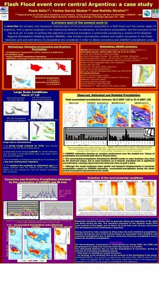
Methodology: BRAMS simulation. Methodology: Estimation of Convective and Stratiform Precipitation. BRAMS 3.2 Brazilian Regional Atmospheric Modeling System version 3.2 Simulation period : March 2007 from 25 to 31 at 12UTC Two-way grid interactive nesting technique

E N D
Methodology: BRAMS simulation Methodology: Estimation of Convective and Stratiform Precipitation BRAMS 3.2 Brazilian Regional Atmospheric Modeling System version 3.2 Simulation period : March 2007 from 25 to 31 at 12UTC Two-way grid interactive nesting technique Number of atmospheric levels: 30; vertical cordinate: shaved eta Horizontal Resolution: Grid 1 - 50 km Grid 2 - 12.5 km, Grid 3 - 3.125 km GDAS analyses from NOAA/NCEP as initial and boundary conditions.Model includes topography data (1km resolution) terrain land use (1kmresolution), soil types (50km resolution) weekly sea surface temperaturesdaily soil moisture heterogeneous fields from USP/CPTECParameterizations: Shallow cumulus:Sousa y Silva; Deep convection: Grell; Explicit convection on Grid 2 and 3 Radiative: Chen and Cotton; Horizontal diffusion:Smagorinsky; Vertical diffusion: Mellor-Yamada; Microphysics: 7 water species, bulk water scheme • - IR Brightness Temperature (235 K contour) to determine precipitation areas • hourly CMOPRH Precipitation Estimation • - FORTRACC technique to following the Mesoscale Convective System Stratiform precipitation < 7.5 mm h-1 Convective precipitation >= 7.5 mm h-1 Large Scale Conditions Observed, Estimated and Modeled Precipitation March 27 12Z Total acumulated precipitation between 26-3-2007 12Z to 31-3-2007 12Z 500 hPa Geopotential and 24-hour tendency 200 hPa Streamlines and wind intensity CMORPH estimations BRAMS Grid 2 BRAMS Grid 3 Observed 850 hPa Geopotential and 24-hour tendency Vertically Integrated Moisture Flux Large scale is dominated by: a strong trough centered on 75°W, that remains stationary over the whole studied period. Associated to the trough a cut-off low remain stationary over the coast of Chile generating large scale upper motion over central Argentina. The availability of moisture is favoured by the presence of a lowover northwestern Argentina. The moisture flux presents an anticiclonic gyre and supply moisture from the Atlantic Ocean, this situation differs from the classical low level jet situation associated with convection. Observed precipitation over central Argentina (red), CMORPH (left) and models forecast by (right) different grids accumulated between March 26 to 31, 2007. Grid 1 (light blue) represent the precipitation forecast for 50 km resolution, Grid 2 (yellow) for 12.5 km and Grid 3 (bordeaux) for 3.125 km respectively. CMORPH estimation denotes an excelent performance over the studied are. Values of precipitation are overestimated close to Buenos Aires. The accumulated precipitation simulated by BRAMS results in most locations very close to the observed values, but in some locations as in Rosario simulated rain is significant overestimated, reaching nearly twice the observed value on grid 2 and 3. Although the model evidences some spatial and temporal misplacements in maximum precipitation respect to CMORPH estimation, accumulated precipitation during the whole period are properly represented by the model. Evolution of the environmental conditions March 30 09 Z March 30 12 Z March 30 15 Z March 30 18 Z March 30 21 Z Convective and Stratiform Precipitation estimated by the combination of CMORPH and IR area 235 K covered area in km2 by the mesoscale convective systems Upper pannel: Reflectivity (shaded), ageostrophic wind (barbs) and vertical velocity (contour). Lower Pannel: Equivalent Potential temperature (shaded), ageostrophic wind (barbs) and meridional ageostrophic wind (contour) Stratiform, convective and total precipitation estimated for all systems that affect the central and northern region of Argentina between March 21 to April 1, 2007. Reflectivity 850 hPa 3 hr - Accumulated Precipitation and reflectivity BRAMS Grid 3 CMORPH March 30 12 Z March 30 15 Z Flash Flood event over central Argentina: a case study Paola Salio(1), Yanina Garcia Skabar(2) and Matilde Nicolini(1) (1)Departamento de Ciencias de la Atmósfera y los Océanos. Centro de Investigaciones del Mar y la Atmósfera. CONICET – UBA (2) Servicio Meteorológico Nacional. Cátedra de Climatología y Fenología Agrícolas. FA – UBA. A primary goal of the present work is: to describe the synoptic and mesoscale characteristics of the environment associated to a flash flood over the central region of Argentina, with a special emphasis in the relationship between the behaviour of convective precipitation and the evolution of the low level jet. In order to achieve this objective a numerical simulation is performed considering a version of the Brazilian Regional Atmospheric Modeling System (BRAMS), that include a microphysics scheme and explicit convection in the finest resolution grid and estimations of precipitation are considered in order to detect convective and stratiform precipitation areas. Convective and Stratiform Activity: Mesoscale convective activity tend to generate during the beginning of the night and decay during the day. The maximum extension of the systems varies from small systems to the bigger one on March 29 at 8Z that cover all area, and shows also developments over northwestern Argentina. Strong convective rates overpass by three times the total stratiform precipitation. Systems during the rest of the period present an equivalent total stratiform and convective precipitation but, in general, convective maximum precipitation occurs before the stratiform precipitation. EnvironmentThe thermodynamic environment is characterized by strong CAPE, low CINE and the presence of a deep flow from the north that shows a LLJ profile. The relationship between the LLJ and the development of convection, during an extreme of convective precipitation shows: deep layer of unstable air toward the storm. an increase in the northerly flow at the moment of the developing of the storm.AKNOWLEDGMENTS: This research is supported by UBA grant X266, ANPCyT grant Nº PICT 07 – 14420 and CONICET PIP N° 5582. First author would like to thank to the Organization Committee of 15 ICCP for the support to participate in the conference