Ocean Circulation
Ocean Circulation. Surface Currents A. Earth tries to balance the budget heat by taking warm water from the equator and transporting it toward the poles. The earth can do this in two ways.

Ocean Circulation
E N D
Presentation Transcript
Surface Currents • A. Earth tries to balance the budget heat by taking warm water from the equator and transporting it toward the poles. The earth can do this in two ways. • 1. Solar heating at the equator causes the water to expand slightly, (3inches) and water at the poles to contract by the same amount. Result is downhill flow in response to gravity (water lags behind and moves toward western boundaries).
2. The main force behind surface currents is wind. Wind causes movement of ocean water, because of friction between the moving air and the sea surface (relation between oceanic circulation and general atmospheric circulation). • a. Water speed can be up to 2% of wind speed.
b. The sea surface does not move in the same direction as the wind; it is deflected by the coriolis effect. • c. Motion of the sea surface is 45 degrees to the right of the wind in the northern hemisphere. (Fridth of Nansen observed ice drift to the right of the wind when his ship was frozen in polar ice 1893-1896).
B. Ekman spiral-friction between successive layers also causes subsurface water to move in response to wind. The transfer of energy between layers is not 100%, so deeper layers move progressively slower. • 1. Each layer moves to the right of the overlying layer above it.
2. Each layer moves in a slightly different horizontal direction. Where water flows in opposite direction of wind is called friction depth. • 3. Ekman Transport– is the summed – up water movement for all the layers in the Ekman Spiral which is 90 degrees to the right in northern hemisphere and 90 degrees to left in southern hemisphere.
C. Flow within a gyre • 1. The ocean currents of the world often flow in large circular patterns around the periphery of an ocean basin. This flow is called a gyre (gyros = circle). The basic combination of • a. Currents being deflected to the right (northern hemisphere). • b. Continents blocking their continuous flow combine to deflect the moving water into a circular pattern.
2. Gyre is subdivided into four interconnected currents, each with distinct flow characteristics and temperature (ex. warm/fast or slow/cold). • a.North Atlantic gyre is an example where east/west currents are deflected to the right of the wind – where flow is blocked by continents the current turns clockwise (right) to complete the circuit.
D. Most cases deflection barely reaches 45 degrees. This deviation from theory occurs because of an interaction between coriolis effect and the pressure gradient. • 1. Some water turns to the right to form a hill. The water cannot continue to the right or it would have to go uphill against the pressure gradient. It cannot go left or it would defy the coriolis effect. The water goes westward, then clockwise (in N. Atlantic gyre) – dynamically balanced between downhill urges of pressure gradient, and uphill tendency of coriolis deflection.
a. Yes, there is a hill of water in middle of gyre. Called Sargasso Sea– formed of surface water gathered at ocean’s center of circulation. • 1. 6.5 ft. gradual rise from coastline. • 2. Hill maintained by wind energy.
3.This balance of wind energy and friction, and of the coriolis effect and pressure gradient propel the currents of the gyre and holds them along the outside edge of the ocean basins
2. Gyres in balance between pressure gradient and coriolis called geostrophic gyres(geos = earth strophic = turning). • A. There are 5 great current circuits in the world ocean. Two in the Northern Hemisphere and three in the South.
1. Northern Hemisphere Gyres are: • North Atlantic Gyre • North Pacific Gyre 2. Southern Hemisphere Gyres are • South Atlantic Gyre • South Pacific Gyre • Indian Ocean Gyre
West wind drift or Antarctic circumpolar current. This is not a closed circuit, not really a gyre it does not flow around an ocean but the whole earth (never deflected by a continent).
E. Currents within Gyres – currents classified by their position within a Gyre and characteristics. • 1. Western boundary currents • a. fastest and deepest geostrophic currents • b. found at western boundaries of ocean basins (off east coast of continents) • c. these move warm water poleward in each gyre
d. five large western boundary currents are • 1. Gulf stream (North At.) • 2. Japan or Kuroshio (NP) • 3. Brazil current (SA) • 4. Agulhas c (Indian) • 5. East Australia c (SP)
Gulf stream= largest of western boundary currents – depth of (1500 ft). Moves more than a 100 miles a day • 2. These western boundary surface currents can often form meanders and eddies • a. Meander – is a loop in the flow • b. If loop connects, can form a turbulent ring or eddy that can trap cold or warm water in their centers and then separate from the main flow
1. If meander breaks off in cold water this is called a warm – core eddy and rotates clockwise • 2. If forms in warm water, called cold – core eddy – rotates counter clockwise • These may be over 600 miles in diameter and retain their identity for three years • Believe they may influence sea-floor (abyssal storms) • These often trap and transport animals to unusual locations, ex. tropical fishes off Long Island are brought by warm – core rings.
http://www.fishchannel.com/saltwater-aquariums/collecting-caribbean-fish-off-long-island-new-york.aspxhttp://www.fishchannel.com/saltwater-aquariums/collecting-caribbean-fish-off-long-island-new-york.aspx
3. Eastern Boundary currents • a. Five at eastern edge of ocean basins (west coast of continent). • 1.Canary C (NA) • 2.Benguela (SA) • 3.California C (NP) • 4.West Australian C (Indian) • 5.Peru or Humboldt C (SP)
b. opposite of their western boundary currents • c. carry cold water toward equator • d. shallow and broad > 620 miles across • e. no eddies, not well defined boundaries • f. total flow is less
4. Westward Intensification of currents is strong currents on western ocean margins caused by the coriolis effect and from the continents blocking the flow of westward currents. Reasons: • a. converging flow from trade winds on each side of equator, force water west then north • b. kept narrow and swift by apex of gyre on left side of ocean
c. constriction of water on left side of gyre • d. little coriolis effect around equator so all water flows straight west • e. higher latitude of gyre is stronger coriolis • f. more water squeezed through smaller space
5. Transverse Currents= currents that flow from east to west and west to east, thus linking the eastern and western boundary currents. • a. Trade winds drive the north and south equatorial currents • b. Westerlies drive eastward flowing transverse currents • c. In for south, west winds drive the largest current called Antarctic circumpolar current (or west wind drift)
6. Counter Currents= a surface current flowing in the opposite direction as the adjacent surface current (occurs around doldrums, where there is little wind)
F. Effects of surface currents on climate • 1. currents can transport heat from the tropics to higher latitudes (Gulf stream makes England have a more mild climate). • 2. Lower latitudes on an oceans eastern boundary the situation is reversed. Cool summers in San Francisco due to cold current. Air loses heat to the cold current.
3. El Nino – A time (about every 3 to 8 yrs) the total winds which blow from east to west weaken or reverse. This change in wind directions called southern oscillation(it is actually a change in pressure resulting in a wind change). • a. The trade winds stack up warm water in western pacific.
b. Wind stops and warm water begins to flow eastward toward Central America. • c. ENSO for El Nino/Southern Oscillation. • d. Last about a year. • e. Effects weather
G. Wind – induced vertical circulation = occurs when wind causes upwelling or downwelling • 1. upwelling = the upward movement of water which brings deep, cold, nutrient rich waters toward the surface. • a. Equatorial upwelling= winds going west move water westward which is replaced by nutrient rich cold water. Evidence of this is layers of ooze on the equatorial Pacific Sea bed.
b. Coastal upwelling= winds blow parallel along coast (eastern ocean boundary) water gets deflected away from coast because of coriolis effect. The water is then replaced by cold nutrient rich deep water. This can influence weather (San Francisco).
2. Downwelling = water driven toward a coastline will be forced downward returning seaward along the shelf. • a. supplies deep ocean with dissolved gases • b. no direct effect on climate
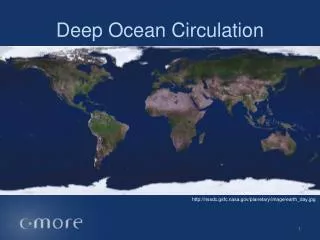
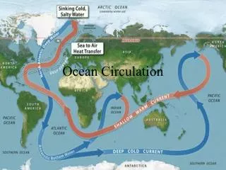
II. Thermohaline Circulation= The slow circulation of water at great depths that is driven by density difference instead of wind energy. • A. Difference in density is due to difference in water temperature and salinity so named thermohaline circulation. • 1. Seawater density increases as salinity increases; density increases as temperature decreases.
2. Increase salinity by evaporation and the formation of sea ice. • 3. Decrease salinity by precipitation at sea surface, land runoff, and melting of ice. • 4. Generally the density of ocean water increases with depth (usually decrease in temp.). • 5. Stable= increases density w/depth and little mixing . Unstable = denser layer on top, this causes mixing. • 6. OMIT
7. In most of the ocean less dense water overlies denser, colder subsurface water. There is a sharp boundary between different densities. • a. Zone of rapid density change is called a pycnocline. • b.Zone of rapid temperature change is called thermocline. • c. Zone of rapid salinity change is called halocline.
8.Layers of ocean water with characteristic temperature, salinity and density are called water masses. These are named according to their relative position. • a. surface water • b. central water • c. intermediate water • d. deep water • e. bottom water
9. These masses get their characteristic at the surface. (Artic is cold and dense) • 10. The basic circulation is dense polar water moving along the seafloor toward the equator. The equator water moves to replace the sinking polar water. The polar water rises up at the equator to replace the surface water moving poleward.