Download
1 / 14
140 likes | 316 Views
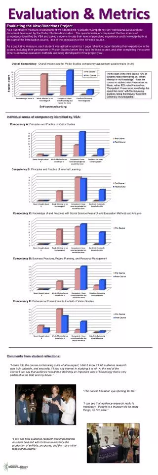
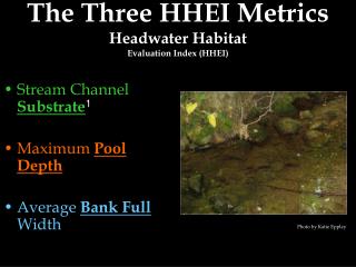
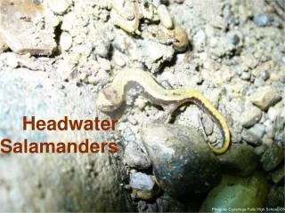
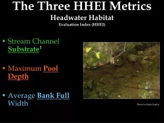
The Three HHEI Metrics Headwater Habitat Evaluation Index (HHEI) . Stream Channel Substrate 1 Maximum Pool Depth Average Bank Full Width. Photo by Katie Eppley. Metric #1-Stream Channel Substrate. Headwater Habitat Evaluation Index (HHEI). Substrate Primary Headwater Streams HHEI.

E N D
The Three HHEI Metrics Headwater Habitat Evaluation Index (HHEI) • Stream Channel Substrate1 • Maximum Pool Depth • Average Bank Full Width Photo by Katie Eppley
Metric #1-Stream Channel Substrate Headwater Habitat Evaluation Index (HHEI)
SubstratePrimary Headwater StreamsHHEI Identify two most dominant substrate types Presence and Percentage Pebble count procedure1 provides good training for assessment of substrate Photo by Matt Wilson
Substrate Why is it important? What is its origin?Primary Headwater StreamsHHEI Substrate Diversity • Number of substrate types More substrate types = more “niches1” Many fish and macroinvertebrate2 species are associated with specific substrate types Substrate Origin • Where did the substrates originate? Bedrock3, tills4, alluivial5 sediments, colluvial6 sediments, etc.
Substrate Primary Headwater StreamsHHEI Nine Substrate Types • Bedrock • Boulder: > 10” flat or round(measured differently) • Boulders as slabs: flat • Cobble: 2.5” to 10” • Gravel: 1/12” to 2.5” • Sand: gritty texture • Silt: greasy texture • Hardpan: usually clay, hard gummy surface • Muck: decayed, organic material • Detritus: leaves, sticks, wood
Substrate Geology & OriginsPrimary Headwater StreamsHHEI Limestone: Often contains fossils, easily scratched with knife, usually bedrock or flat boulders and cobbles Tills: Sediments deposited by glaciers; particles often rounded. Can be carried into non-glaciated areas Wetlands: Usually organic muck and detritus Hardpan: Clay – smooth, usually slippery Sandstone: Contains rounded fragment of sand “cemented” together Rip/Rap: Artificial boulders Lacustrine1: Old lake bed sediments Shale2: “Claystone,” sedimentary rock made of silt/clay, soft and cleaves easily Coal Fines: Black fragments of coal, generally SE Ohio only
Metric #2-Maximum Pool DepthPrimary Headwater Streams Headwater Habitat Evaluation Index (HHEI)
Maximum Pool DepthPrimary Headwater StreamsHHEI The Basics - What is a PrimaryHeadwater Stream? • A surface watercourse with a defined bed and bank • Either continuous or periodical flowing water • A watershed generally less than one square mile and deepest pools < 40cm • Widely divergent communities based upon in-stream biology
Maximum Pool DepthPrimary Headwater StreamsHHEI • Maximum pool depth is a key indicator of whether the stream can support a well balanced fish community • Streams with pools less than 40 cm in depth are less likely to have well balance fish communities, and are more likely to support dense populations of lungless salamanders. • Maximum pool depth is also related to the stream channel (i.e., continuous, intermittent, interstitial), and thus serves as a good discriminator of the various classes of PHWH streams.
Metric #3- Average Bank Full Width Headwater Habitat Evaluation Index (HHEI)
Bank Full WidthPrimary Headwater StreamsHHEI What is bank full width? “ ... the discharge at which channel maintenance is the most effective, that is, the discharge at which moving sediment, forming or removing bars, forming or changing bends and meanders, and generally doing work that results in the average morphologic characteristics of channels.” Dunne and Leopold (1978) Bankfull Width is a strong discriminator of the three types of PHWH streams in Ohio (Class I, II, III).
Bank Full WidthPrimary Headwater StreamsHHEI How do you find bank full width? The bank full width of a stream channel should be measured in riffle1 areas (or in a glide/run in the absence of riffles.) A relatively straight stream segment should be selected which is not affected by the deposition of debris. The boundary line where terrestrial vegetation begins along the stream margin can also indicate the edge of the bankfull width.
Bank Full WidthPrimary Headwater StreamsHHEI Once there is confidence in the bankfull boundary, stake the measuring string at that point, and use the following procedure to determine the bank full width HHEI metric (see Figure 6). 1. Place bubble type line level1 on measuring string. 2. Suspend the measuring string perpendicular to the stream flow from the staked location to the opposite bank. 3. Pull string taunt and manipulate up and down until the line level indicates that the string is level. Mark the location where the string intersects the opposite bank. 4. Measure the distance between the marked bankfull locations on either bank of the stream. 5. Take 3-4 measures throughout the 200 ft (61 m) stream reach and calculate an average bank full width for the stream segment. Record result on the PHWH Form in the space provided.
Glossary • Pebble Count Procedure – Method used to determine the two most prominent substrate groups for HHEI classification. • Substrate - The base on which an organism lives. • Niche - The position or function of an organism in a community of plants and animals. • Macroinvertebrate - An invertebrateanimal (animal without a backbone) large enough to be seen without magnification • Bedrock - The solid rock that underlies loose material, such as soil, sand, clay, or gravel. • Tills - An unstratified, unconsolidated mass of boulders, pebbles, sand, and mud deposited by the movement or melting of a glacier. The size and shape of the sediments that constitute till vary widely. • Alluivial - Relating to something in streams and rivers or created/deposited by stream action. • Colluvial - Loose earth material that has accumulated at the base of a hill, through the action of gravity, as piles of talus, avalanche debris, and sheets of detritus moved by soil creep or frost action. • Riffle- Fast moving shallow water. • Bubble type line level – A string with a bubble level on it to determine if the string measuring Bank Full Width is level. • Lacustrine - Of or having to do with a lake, of, relating to, or formed in lakes, growing or living in lakes, of or relating to dwellings built on piles in lakes. • Shale – A fine-grained sedimentary rock of a thin, laminated, and often friablestructure.