Download
1 / 12
120 likes | 307 Views
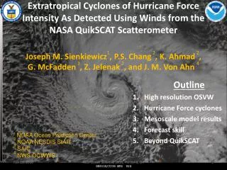
Extratropical Cyclones of Hurricane Force Intensity As Detected Using Winds from the NASA QuikSCAT Scatterometer Joseph M. Sienkiewicz 1 , P.S. Chang 2 , K. Ahmad 2 , G. McFadden 3 , Z. Jelenak 2 , and J. M. Von Ahn 4. Outline High resolution OSVW Hurricane Force cyclones

E N D
Extratropical Cyclones of Hurricane Force Intensity As Detected Using Winds from the NASA QuikSCATScatterometerJoseph M. Sienkiewicz1, P.S. Chang 2, K. Ahmad 2, G. McFadden 3, Z. Jelenak 2, and J. M. Von Ahn4 Outline High resolution OSVW Hurricane Force cyclones Mesoscale model results Forecast skill Beyond QuikSCAT 1 NOAA Ocean Prediction Center 2 NOAA NESDIS StAR 3 SAIC 4 NWS OCWWS AGU Ocean Sciences 2010, Portland, OR
High resolution Ocean Surface Vector Winds (OSVW) fully integrated into operations • Twice daily near complete wind field • Increased situational awareness • Improved detection and warning capability • Enhanced understanding of winds overoceans • Allowed focus on extreme cyclones (Hurricane Force) QuikSCAT AGU Ocean Sciences 2010, Portland, OR
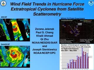
Hurricane Force Extra-tropical Cyclones – Detection and Warning Trend using QuikSCAT2000-2009 • Hurricane Force Warning Initiated Dec 2000 • Detection increased with: • Forecaster familiarity • Data availability • Improved resolution • Improved algorithm Improved wind algorithm and rain flag Oct 06 WARNING CATEGORIES Pre- QSCAT 1. GALE 34-47 kt 2. STORM >48 QSCAT ERA 1. GALE 34-47 kt 2. STORM 48 -63 kt 3. HURCN FORCE > 64 kt 12.5 km QuikSCAT available May 04 25 km QuikSCAT Available in N-AWIPS Oct 01 Hurricane Force Wind Warning Initiated Dec 00 Totals A-289 P-269 558 QuikSCAT Launch Jun 99 AGU Ocean Sciences 2010, Portland, OR
2001-2009 Climatology Peak activity Dec, Jan – Pacific Jan, Feb – Atlantic • Atlantic • Pacific Bombs Deepening Rates Explosive deepeners “Bombs” Pacific faster deepeners AGU Ocean Sciences 2010, Portland, OR
Hazard toopen Waves Geographic Distribution of Hurricane Force Extra-tropical Cyclones Primary impact - open ocean Do make landfall Waves impact coasts North Atlantic 4,000/yr container transits 1,000/yr bulkers North Pacific 6,000/yr container transits 1,500/yr bulker AGU Ocean Sciences 2010, Portland, OR
QuikSCAT composites of cyclones at HF Intensity 3000 3000 2000 2000 1000 1000 Hurricane Force Wind Frequency Storm Force Wind Frequency Cyclones ~6000 km diameter asymmetric wind field HF winds ~ 1000 km S of center • Range rings • 1000 km increments • ~ 500 wind fields for • composites 3000 2000 1000 AGU Ocean Sciences 2010, Portland, OR Gale Force Wind Frequency
Hurricane Force Winds • Successfully modeled • Onset, rapidly deepening phase • Bent-back front, key ingredient for low level jet • Mesoto small synoptic scale • Need validation effort for extreme conditions!! • Using results to tailor ensemble based forecast guidance Weather Research and Forecast (WRF) Model Results WRF - 10m Winds 925 hPa - Frontal zones WRF Simulation Pacific Feb 2008 cyclone AGU Ocean Sciences 2010, Portland, OR
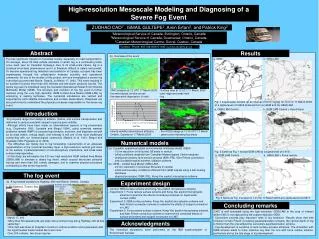
Key Flight level GPS dropsonde Time (UTC) SFMR WS NOAA Aircraft ResearchWinter Ocean Storms Feb 4, 2010 HF drops HF SFMR • High Winds Research • validation set for remotely sensed winds • ASCAT, OceanSat-2, future instruments • NWP forecast models • Instrumentation • GPS dropsondes, Step Freq. Mirowave Radiometer • UMASS Imaging Wind and Rain Air-borne Profiler (IWRAP) AGU Ocean Sciences 2010, Portland, OR
Track error comparable to NHC Atlantic TC error (~25 nm/12 hrs) • Under predict depth and wind speed at day 4 • Forecast challenges remain • basically can predict a major cyclone and where • intensity remains a challenge Experimenting with ensemble approach • Promising but lacking representation of higher wind speeds • Calibration with 10 year QuikSCAT wind speeds • Evaluating 925 mb winds Day 2/4 Cyclone Forecast Verification Ensemble wind speed probabilities 34 kt 48 kt 34 kt 48 kt 60 kt 64 kt 60 kt 64 kt F24 F96 AGU Ocean Sciences 2010, Portland, OR
Major Forecast Challenges Remain 972 HURCNFORCE 970 HURCNFORCE 48 hr forecast 991 DVLPGSTORM Surface Analysis 96 hr forecast AGU Ocean Sciences 2010, Portland, OR
Beyond QuikSCAT 0707 UTC 23 Nov 2009 • ASCAT on European MetOp series • Excellent operational instrument • Less coverage, low bias at high winds • NESDIS StAR Winds Team • improving performance in high winds • Indian OceanSat-2 • NOAA working with ISRO for potential NRT data access • Global Change Observing Mission (GCOM-W2) • NOAA Dual Frequency Scatterometer with JAXA AMSR-3 • In discussion, requirements documents drafted • Forecasters • Rely on ASCAT, ship observations, satellite interpretation skills, and NWP analyses and short term forecasts • However, situational awareness is reduced AGU Ocean Sciences 2010, Portland, OR
Summary • Hurricane force winds more frequent than thought • Better understand wind evolution in extreme ocean storms • QuikSCAT and mesoscale model results agree • QuikSCAT loss, forecasters have lost temporal consistency • Impact to both detection and verification • Forecasting conditions beyond 3 days is still difficult • Resolution, predictability • Mitigation efforts ongoing • Optimize ASCAT • Potential for NRT winds from ISRO OceanSat-2 • Potential Dual Frequency Scatterometer with JAXA GCOM-W2 AGU Ocean Sciences 2010, Portland, OR