Download
1 / 50

E N D
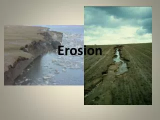
Costal Erosion: “Approximately 25 percent of homes and other structures within 500 feet of the U.S. coastline and the shorelines of the Great Lakes will fall victim to the effects of erosion within the next 60 years, according to a study released by the Federal Emergency Management Agency (FEMA).” http://www.fema.gov/nwz00/erosion.shtm
Coastal Evolution • Balance between: • Wave action (energy, geology) • Sediment supply • Sea level
Wave base: point at which wave action becomes negligible on the sea floor It is the effective lower limit of wave action and erosion /2 = wave base Erosion and movement by WAVES
Waves • So, surf is a powerful erosive agent • Its energy is expressed by turbulence… • …violent movements of parcels of water which are able to move and suspend sediment
Sediment movement - redistribution by WAVES • Longshore transport: waves hitting coast obliquely, depends on prevailing winds • waves have both a perpendicular and parallel component relative to the coast • the parallel component represents longshore drift; transport of sediment along the beach
Wave Refraction • Waves change path when they reach shallow water • Wave energy is concentrated on headlands and spread out in bays
Rips • When waves break parallel to a beach, rips occur
Rip currents: water that flows straight out to sea from the surf zone. Travel at the surface and die out at depth. Carry fine grained particles out of surf zone to deeper water.
Summer Winter
Sediment movement - redistribution by WAVES • Longshore transport or Beach drift: oblique waves which move sediment along the beach • Storm transport: very rapid erosion, much larger than normal, which tends to narrow beaches and move sediment offshore
Sea Level Change 1. Glaciers • Glaciers Lower Sea Level Slowly • They Melt quickly – sea level rises 2. Mid Ocean Ridges • Mid Ocean Ridge raises sea level if large and active • Lowers sea level if activity slows - becomes smaller
Sea level rise • linked to global warming, either natural or human-induced • over next century, we anticipate sea level to rise by 30-100 cm • along the east coast where the coastal plain rises gently, this rise translates to a shoreline setback of 100-400 feet.
Shoreline shift • Impact of sea level rise is greatest in low coastal areas http://pubs.usgs.gov/circ/c1075/contents.html
Effects of the Pleistocene • Sea level has risen at least 100 meters in the last 18,000 years • Most coastlines globally are submergent • Primary coastlines are very common
Nonmarine Processes - Uplift Convergent Margins
Artificial structures and beach erosion • Dams • Groins • Breakwaters • Seawalls • Inlets, dredging, and jetties
Santa Cruz Harbor, California Direction of current
Our efforts to control nature can be a expensive struggleSanta Barbara Harbor in 1931 Source:Fairchild air photos 0-139 & E-5780, UCLA Department of Geography Aerial Photo Archives
Santa Barbara Harbor in 1977 Source:John S. Shelton
From Dean (1999) Groins • Designed to trap sediment… • but they instead progressively starve beach of sediment in the direction of longshore-littoral current
Groins off Cape May, New Jersey Source:John S. Shelton
Further effects of groins Highly eroded beach Rockaway beach, New York Eroded beach…compare buildings on either side of groin
Breakwaters • Designed to allow sediment to settle • Smaller waves behind, less sediment is transported From Dean (1999)
Seawalls • Various types: revetments, rip-rap, concrete walls, piles of rubble, etc. • Nearly 100% of the time they damage or destroy a beach which is eroding to begin with Loss of beach Flooding of beach Destruction of seawall From Dean (1999)
Beach-Protection Structures - Riprap Source:Jack Dermid /Photo Researchers, Inc.
Beach-Protection Structures –Seawall Along the Gulf Coast of Louisiana Source:Martin Miller
The consequences of NO BEACH • Hugely costly measures are required to restore beach, e.g., pumping sand, and this is only a temporary solution • Also, houses are now closer to the water and more vulnerable • On either end of the seawall, the beach erodes and is displaced toward the land naturally…so the walled part of the beach is exposed to the ocean and vulnerable to storms
From Dean (1999) Sand bypassing to replenish beach on down-current side of jetty Replenishing sand the old-fashioned way
Inlets • Inlets are created naturally by large storms…they are breaks in a barrier beach • Over time, the inlet will heal naturally • The inlet can heal rapidly, or can linger for years or decades From Dean (1999)
Closing of an inlet • The healing time of an inlet depends on: • -amount of sand transported by littoral drift • -amount of water flowing through with tide • Thus, if the tidal flow is low and littoral currents carry abundant sand, the inlet can heal quickly • Flood tide deltas represent a large amount of sand carried inside the inlet’s mouth • This is a natural sink for sand, and the sand remains relatively undisturbed
Inlets are kept open artificially sometimes, e.g., for a harbour, fishing fleet, etc. If so, inlet needs to be dredged periodically The dredged sand is often dumped in deep water offshore…the sand is therefore lost If sand were dumped on the beach down-current, beach might be stabilized…but not an easy task due to the high-energy surf zone Inlets and dredging
Inlets and jetties • Another way to keep inlets open artificially is by building jetties • The jetties serve to “jet” out sand into deeper water…again, a loss • The longer the jetty, the worse the erosion down-current
Jetty in Miami Beach, Florida Source:Townsend P. Dickinson
Artificial modification of inlets • One problem is political…stakeholders may have diametrically opposite viewpoints… • …e.g., tourism operators who need a beach vs. fishing fleets who want easy access to the ocean through the inlet • One solution is sand-bypassing, but this is expensive and inefficient compared to Mother Nature