Atmospheric Circulation in a nutshell
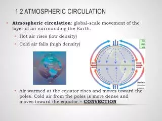
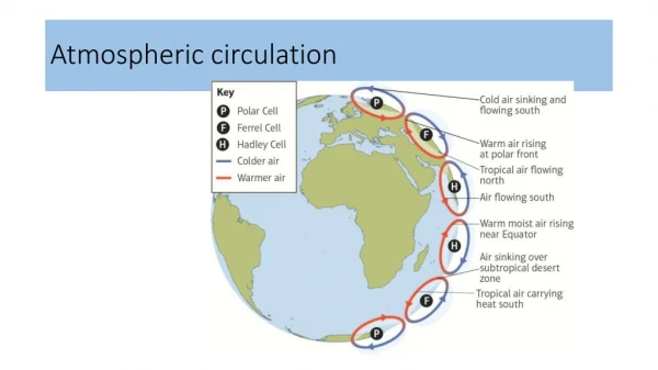
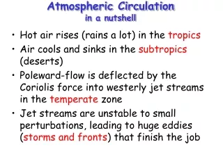
Atmospheric Circulation in a nutshell. Hot air rises (rains a lot) in the tropics Air cools and sinks in the subtropics (deserts) Poleward-flow is deflected by the Coriolis force into westerly jet streams in the temperate zone

Atmospheric Circulation in a nutshell
E N D
Presentation Transcript
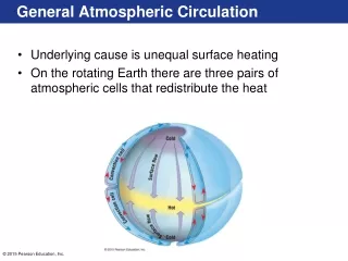
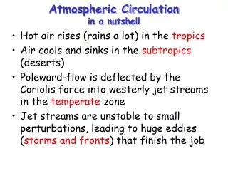
Atmospheric Circulationin a nutshell • Hot air rises (rains a lot) in the tropics • Air cools and sinks in the subtropics (deserts) • Poleward-flow is deflected by the Coriolis force into westerly jet streams in the temperate zone • Jet streams are unstable to small perturbations, leading to huge eddies (storms and fronts) that finish the job
Jet Streams • Subtropical Jet is zonal mean response to poleward flow in upper branch of Hadley Cell • Polar front jet is response to pole-equator temperature difference
ExtratropicalStorms are Eddies in the Jet Stream • Momentum is transferred from the earth to the atmosphere in the trade wind belt. • Momentum is transferred from the atmosphere to the earth in the midlatitudes. • If the earth is always trying to slow down the midlatitude westerlies, why don’t they weaken and disappear over time? - Eddies (storms) transfer momentum poleward in the upper troposphere. - This momentum transfer weakens the Hadley circulation, but drives the Ferrel cell.
Waves on the polar vortex Hemispheric westerlies typically organized into 4-6 “long waves” Wind blows through them, but the waves themselves propagate slowly or not at all
Midlatitude Cyclones Equator-to-pole temperature gradient tilts pressure surfaces and produces westerly jets in midlatitudes Waves in the jet induce divergence and convergence aloft, leading to surface highs and lows Surface circulations amplify the wave by transporting heat to the north and south around the surface low Resulting “cyclones” are crucial to the transport of energy through the middle latitudes Lowers center of mass of atmosphere
Low High Convergence and Divergence What initiates “cyclogenesis?” When upper-level divergence is stronger than lower-level convergence, more air is taken out at the top than is brought in at the bottom. Surface pressure drops, and the low intensifies, or “deepens.” 500 mb height
Divergence, Spin, and Tilt • Maximum upper level convergence and divergence are between ridges and troughs • Phase of developing wave “tilts” to the west with height
Before the Storm • Vertical cross-section looking North • Imagine a jet-stream wiggle passes overhead • Where will surface low develop? High Low DIV east
Birth of a Storm • Surface winds respond to surface pressure gradient … transport cold air southward behind the low and warm air northward ahead of low • This amplifies the upper level trough and ridge • Enhances upper-level divergence High High Low Low DIV DIV warm cool Low east
How to “Grow” a Storm • Upper level shortwave passes • Upper level divergence-> sfc low • Cold advection throughout lower troposphere • Cold advection intensifies upper low • Leads to more upper level divergence Temperature advection is key!
Fronts AFront - is the boundary between air masses; normally refers to where this interface intersects the ground (in all cases except stationary fronts, the symbols are placed pointing to the direction of movement of the interface (front) Warm Front Cold Front Stationary Front Occluded Front
Stationary front Open wave Incipient cyclone dissipating occlusion Mature stage Lifecycle of a Midlatitude Cyclone Green shading indicates precipitation Takes several days to a week, and moves 1000’s of km during lifecycle
What maintains the surface low? Imagine a surface low forming directly below upper level low Surface convergence “fills in” the low Surface divergence “undermines” the high
Actual vertical structure Upper level low is tilted westward with height with respect to the surface. UPPER LEVEL DIVERGENCE INITIATES AND MAINTAINS A SURFACE LOW.
Cold Front Structure • Cold air replaces warm; leading edge is steeper due to friction at the ground • Strong vertical motion and unstable air forms cumule clouds (thunderstorms!) • Upper level winds blow ice crystals downwind creating cirrus and cirrostratus
Warm Front Structure • In an advancing warm front, warm air rides up over colder air at the surface; slope is not usually very steep • Lifting of the warm air produces stratus clouds and precipitation well in advance of boundary • At different points along the warm/cold air interface, the precipitation will experience different temperature histories as it falls to the ground
Summary of Cyclone Weather Roles of convergence and divergence aloft Pattern of clouds, precipitation, and temperatures on the ground
“Conveyor Belts” This model describes rising and sinking air along three “conveyor belts” A warm conveyor belt rises with water vapor above the cold conveyor belt which also rises and turns. Finally the dry conveyor belt descends bringing clearer weather behind the storm.
Follow the Energy! • Midlatitude storms release gravitational potential energy arising from the temperature differences found in the different air masses north and south of the polar front • Cold, dense air pushes warmer, less dense air up and out of the way • “Up warm, down cold” • These storms let the atmosphere lower its center of mass … “air falling down”
The Big Picture • The general circulation transports energy upward and poleward to balance radiational losses to space • The Earth’s rotation complicates this! • The Hadley cell imports water vapor and condenses it to lift the tropical atmosphere, tilting pressure surfaces toward the poles • The resulting polar vortex is unstable, producing waves in the jets that allow energy transport across the midlatitudes (and which also control winter weather!)