Download
1 / 32
320 likes | 596 Views
Speaker: Yi-Fan Chang Advisor: Prof. Jian-Jiun Ding 2012/12/07. An Introduction to FORMOSAT-3/COSMIC. Outline. Introduction System and Mission Overview GPS Radio Occultation Current Status Data Analysis Discussion Conclusion Reference. Outline. Introduction

E N D
Speaker: Yi-Fan Chang Advisor: Prof. Jian-Jiun Ding 2012/12/07 An Introduction toFORMOSAT-3/COSMIC
Outline • Introduction • System and Mission Overview • GPS Radio Occultation • Current Status • Data Analysis Discussion • Conclusion • Reference
Outline • Introduction • System and Mission Overview • GPS Radio Occultation • Current Status • Data Analysis Discussion • Conclusion • Reference
Introduction • Name: • FORMOSAT-3/COSMIC (Constellation Observing System for Meteorology, Ionosphere, and Climate). • Objective: • Demonstrate the value of near-real-time GPS Radio Occultation(掩星) observations in operational numerical weather prediction. • Major participants: • UCAR,OSC,NSF,JPL,NRL,AFRL,NSPO
Introduction • Characteristics : • Number: 6 identical LEO satellites (FM1-FM6) • Shape: Disc-shaper of 103cm diameter, 16cm in height • Weight: 62 Kg (include fuel) • Design & Mission life: 5 years • Launch date: 2006/04/15
Introduction • Characteristics : • Orbit: 516 Km -> 700-800 Km (FM3: 711 Km) • Inclination Angle: 72 degrees • Argument of Latitude: 30 degrees apart
Introduction • Provide: • 1500~2000 atmospheric and ionospheric sounding profiles per day • Benefits: • Increase the accuracy of the predictions of hurricane/typhoon/cyclone behavior. • Improve long-range weather forecasts. • Monitor climate change with unprecedented accuracy.
Outline • Introduction • System and Mission Overview • GPS Radio Occultation • Current Status • Data Analysis Discussion • Conclusion • Reference
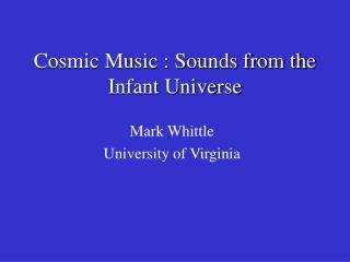
System and Mission Overview • Three onboard payloads: • GPS Occultation Receiver (GOX) (GPS掩星接收器) • 4 GPS antenna (POD1, POD2, OCC1, OCC2) • Receive the signals of L1 and L2-band frequency • Tri-Band Beacon (TBB)(三頻段信標儀) • 150, 400, 1067 MHz • High resolution 4-Dtotal electron content • Tiny IonosphericPhotometer (TIP) (小型電離層光度計) • 135.6 nm
NMC/USN Users Users System and Mission Overview FORMOSAT-3 L1&L2 L1&L2 Ground System GPS GPS Payload science data Injection Orbit TBB signal Command & telemetry Remote Terminal Stations (RTS) Fairbanks, US and Kiruna, Sweden TBB chains Fiducial Network TT&C, Taiwan Multi-Mission Center (MMC), Taiwan CDAAC/UCAR Boulder,CO TACC/CWB Taipei
Outline • Introduction • System and Mission Overview • GPS Radio Occultation • Current Status • Data Analysis Discussion • Conclusion • Reference
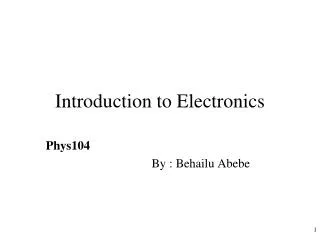
GPS Radio Occultation • GPS system: • Number: 30 satellites up • Orbit: 20200 Km • Each orbit contains at least 4 satellites • Needs 4 satellites for 3D positioning • L1 and L2-band frequency carrier wave • 10.23MHz --> 1.58GHz and 1.23GHz
GPS Radio Occultation GPS Satellite Radio Wave Formosat-3/COSMIC Orbit Formosat-3/COSMIC Satellite
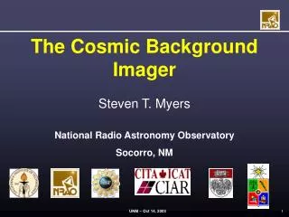
GPS Radio Occultation α GPS satellite LEO satellite Earth Neutral atmosphere Ionosphere
Outline • Introduction • System and Mission Overview • GPS Radio Occultation • Current Status • Data Analysis Discussion • Conclusion • Reference
Outline • Introduction • System and Mission Overview • GPS Radio Occultation • Current Status • Data Analysis Discussion • Conclusion • Reference
Data Analysis Discussion • Analysis Objects: • Sun Beta Angle • Flip-Flop • Battery Aging Trends • Reaction Wheels • SNRs of GOX Payloads • Analysis Methods: • Hilbert-Huang Transform • Shot-Time Fourier Transform
Beta Angle Sun Beta Angle Low Beta Angle (0 degree) High Beta Angle (90 degree) Eclipse Zone
SNRs of GOX Payloads Anttena 0: POD1 Anttena1: POD2 Anttena2: OCC1 Anttena3: OCC2
Conclusion • The FORMOSAT-3/COSMIC mission initiates a new age for operational GPS-RO soundings for monitoring and forecasting of weather. • The advanced adaptive analysis methods (STFT and HHT) are useful to analyze the trending data.
Reference • [1]C.-J.Fong, S.-K. Yang, C.-H.Chu, C.-Y. Huang, J.-J. Yeh, C.-T. Lin, T.-C. Kuo, T.-Y. Liu, N. Yen, S. S. Chen, Y.-H. Kuo, Y.-A. Liou, and S.Chi, “FORMOSAT-3/COSMIC constellation spacecraft system performance: After One Year in Orbit”, IEEE T. Geosci. Remote, 46(11), 3380–3394, doi:10.1109/TGRS.2008.2005203, 2008b. • [2] C.-J. Fong, D. Whiteley, E. Yang, K. Cook, V. Chu, B. Schreiner, D. Ector, P. Wilczynski, T.-Y. Liu, & N. L. Yen, “Space & Ground Segment Performance of the FORMOSAT-3 / COSMIC Mission: Four Years in Orbit,” Atmospheric Measurement Techniques Journal (AMTJ), Vol. 4, 2011, pp. 1115-1132. Doi:10.5194/amt-4-1115-2011. • [3] Chen-Joe Fong; Yen, N.L.; Chang, G.; Cook, K.L.B.; Wilczynski, P.; , "Future Low Earth observation Radio Occultation mission: From research to operations," Aerospace Conference, 2012 IEEE , vol., no., pp.1-10, 3-10 March 2012 • [4] 方振洲、丁建均、王麗豐、顏隆政、楊善國、張明雄、李宗平、王逸民, “適應性分析方法於福衛三號衛星資料之應用,” 中華民國航空太空學會學術研討會, Dec. 2012 • [5] National Space Organization:http://www.nspo.narl.org.tw/tw/ • [6] Global Positioning System: http://en.wikipedia.org/wiki/Global_Positioning_System