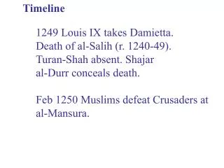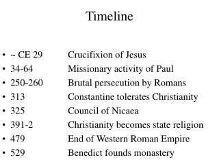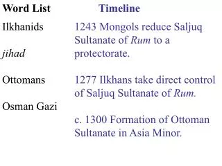
Timeline
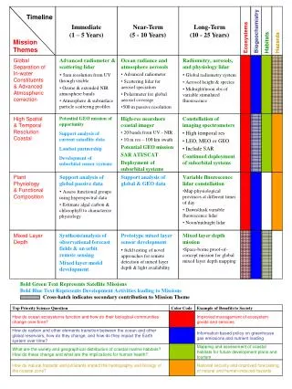
Immediate (1 – 5 Years). Near-Term (5 - 10 Years). Long-Term (10 - 25 Years). Timeline. Ecosystems. Biogeochemistry. Habitats. Hazards. Mission Themes. Global Separation of In-water Constituents & Advanced Atmospheric correction. Advanced radiometer & scattering lidar

Timeline
E N D
Presentation Transcript
Immediate (1 – 5 Years) Near-Term (5 - 10 Years) Long-Term (10 - 25 Years) Timeline Ecosystems Biogeochemistry Habitats Hazards Mission Themes Global Separation of In-water Constituents & Advanced Atmospheric correction • Advanced radiometer & scattering lidar • 5nm resolution from UV through visible • Ozone & extended NIR atmosphere bands • Atmosphere & subsurface particle scattering profiles • Ocean radiance and atmosphere aerosols • Advanced radiometer • Scattering lidar for aerosol speciation • Polarimeter for global aerosol coverage • 500 m passive resolution • Radiometry, aerosols, and physiology lidar • Global radiometry system • Aerosol height & species • Midnight/noon obs of variable stimulated fluorescence Potential GEO mission of opportunity Support analysis of current sataellite data Landsat partnership Development of suborbital sensor systems • High-res nearshore coastal imager • 20 bands from UV - NIR • 10 m res – 100 km swath • Potential GEO mission • SAR ATI/SCAT • Deployment of suborbital systems • Constellation of imaging spectrometers • High temporal res • LEO, MEO or GEO • Include SAR • Continued deployment of suborbital systems High Spatial & Temporal Resolution Coastal Plant Physiology & Functional Composition • Support analysis of global passive data • Assess functional groups using hyperspectral data • Estimate algal carbon & chlorophyll to characterize physiology Support analysis of global & GEO data • Variable fluorescence lidar constellation • Map physiological provinces at different times of day • Dawn/dusk variable fluorescence lidar • Noon/midnight lidar Mixed Layer Depth Synthesis/analysis of observational forecast fields & on orbit remote sensing Mixed layer model development • Prototype mixed layer sensor development • field testing of novel approaches for remote detection of mixed layer depth & light availability • Mixed layer depth mission • Space-borne proof-of-concept mission for global mixed layer depth mapping Bold Green Text Represents Satellite Missions Bold Blue Text Represents Development Activities leading to Missions Cross-hatch indicates secondary contribution to Mission Theme Top Priority Science Question Color Code Example of Benefits to Society How do ocean ecosystems function and how do their biological communities change over time? Improved management of ecosystem goods and services How do carbon and other elements transition between the ocean and other global reservoirs, how do they change, and how do they impact the Earth system over time? Information based policy on greenhouse gas emissions and nutrient loading What are the variety and geographical distribution of coastal marine habitats? How do these change and what are the implications for human health? Mapping and assessment of coastal habitats for future development plans and tourism How do natural hazards and pollutants impact the hydrography and biology of the coastal zone? National security and improved forecasting of natural and human-induced hazards