Download
1 / 24
240 likes | 370 Views
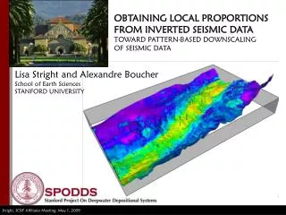
OBTAINING LOCAL PROPORTIONS FROM INVERTED SEISMIC DATA TOWARD PATTERN-BASED DOWNSCALING OF SEISMIC DATA. Lisa Stright and Alexandre Boucher School of Earth Sciences STANFORD UNIVERSITY. Multiple-point geostatistics - SNESIM. A = Categorical Variable B = Training image C = Seismic Probability.

E N D
OBTAINING LOCAL PROPORTIONS FROM INVERTED SEISMIC DATATOWARD PATTERN-BASED DOWNSCALINGOF SEISMIC DATA Lisa Stright and Alexandre BoucherSchool of Earth SciencesSTANFORD UNIVERSITY
Multiple-point geostatistics - SNESIM A = Categorical Variable B = Trainingimage C = Seismic Probability P(A = channel | B = TI ) = 4/5 = 80% P(A = non-channel | B = TI ) = 1/5 = 20% Journel, 1992; Guardiano and Srivastava, 1992; Strebelle, 2000, 2002
Multiple-point geostatistics with soft data 1 Probability 0 Seismic Attribute A = Categorical Variable B = Trainingimage C = Seismic Probability P( A = channel | B = TI ) = 4/5 = 80% P( A = non-channel | B = TI ) = 1/5 = 20% P( A = channel | C = Seismic ) = 70% 1 0 P( A | B, C ) - Combine with Tau Model - Use dual training images
Scaling and probabilities? #1 #2 #3 PSand 47% 47% 47% 47% 20% 20% 20% 20% SeismicAttribute 1 Probability 0 Seismic Attribute Realization(s) Data Calibration
Assumptions – Scale??? Well 190 180 170 160 150 140 130 ~ 100 m 120 110 100 90 80 70 Model scale 60 ~ 100 m 50 Meters to 10’s of meters 40 30 ? 20 1 m 10 0 after Campion et al., 2005; Sprague et al., 2002, 2006 10’s of meters Probabilities and Facies can be scaledto the model grid • Seismic informs a homogeneous package • Homogeneous package can be represented by “most of” facies upscaling in wells Probabilities account for inexact relationship between wells and seismic attribute(s) (10’s)meters Seismic
Proposed approach or methodology Assumptions challenged when: • System is heterolithic (more than two categories) • Heterogeneities are smaller than seismic resolution (always?) • Multiple seismic attributes lumped into probabilities Proposed Solution: • Create a multi-scale, multi-attribute well to seismic calibration • Use calibration to obtain local facies proportions at each seismic voxel location Advantages of proposed approach • Can use any number of seismic attributes • Not dependent upon forward modeling (but can leverage forward modeling) • Uncertainty in tie between data types • Considers underlying cause of fine scale heterogeneity on coarse scale measurement response • Powerful when combined with knowledge of data (rock physics response, depositional setting and patterns)
Local Proportions from seismic attributes ? Seismic Attributes Seismic Attribute #2 Seismic Attribute #1 • Directly from calibration • From forward modeling Realization(s) Data Calibration
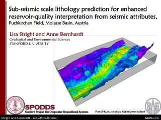
Validation: Upper Cretaceous Cerro Toro Formation, Magallanes Basin
Wildcat Lithofacies Channel fill • Clast supported conglomerate • Conglomeratic mudstone • Thick bedded sandstone Out-of-channel • Interbedded sandstone & mudstone • Mudstone with thin sand interbeds
Rock Properties:Late Oligocene Puchkirchen Formation, Molasse Basin, Austria Bierbaum 1 17km 10km AI (g/cm3m/s) 5000 13000
Multi-scale, multi-attribute calibration 2.2 2.2 2.1 2.1 2 2 1.9 1.9 1.8 1.8 1.7 1.7 1.6 1.6 1.5 1.5 1.4 1.4 4 6 8 12 10 4 6 8 12 10 Vp / Vs Acoustic Impedance (g/cm3 m/s)
Create synthetic properties: Markov Chains 2.2 2.2 2.1 2.1 2 2 1.9 1.8 1.9 1.7 1.6 1.5 1.8 Vp / Vs 1.4 4 6 8 12 10 1.7 1.6 1.5 1.4 4 6 8 12 10 Acoustic Impedance (g/cm3 m/s) Synthetics
Forward and Inverse Modeling 15 Hz 25 Hz 50 Hz
Realizations ThinBeds(s) Sandstones(s) Conglomerate(s)
Outcrop results: Local Proportions Prediction “good” when mean bed thickness is at least 1/10 of seismic resolution
Subsurface Application: Single Well 13000 6000
Subsurface application: log validation Realization # Proportion Is Ip Vp/Vs
Subsurface Application: Single Well 13000 6000 1 0
Stratigraphic Layer 3 Prop( Conglomerate | Ip, Is, Vp/Vs ) Prop( ThinBeds | Ip, Is, Vp/Vs ) Prop( Sand | Ip, Is, Vp/Vs ) Prop( Mud/Disturbed | Ip, Is, Vp/Vs )
Summary and Conclusions • Multi-scale, multi-attribute calibration • Extract more information from well to seismic calibration to define inhomogeneous seismic “packages” • Explicitly handling scale differences in data to get full information content of each data source • Aid in calibrating inexact relationship between wells and seismic • Facies from wells/core • Multiple attributes from seismic • Gaps of unsampled events filled with forward modeling • Proportions and stacking patterns (vertical and lateral) need to be considered together • Underlying “patterns” linked to better search uncertainty space
Future Work Methodology Validation with Outcrop Models • What is the effect of seismic resolution and/or noise on the predictions? • What controls when a proportion set is prediction correctly? • Number of facies? • Bed thicknesses? • Stacking patterns? • Surrounding facies? Calibration and Realizations • More intelligent selection of proportions based on spatial relationship with adjacent cells • Leverage the tie between the proportion and the underlying “pattern” Determine which proportions are consistently predicted with multiple realizations and “freeze” • Analyze to better understand seismic “packages” • Remaining components defined by the model (Training Image) Training Image generation and modeling
Acknowledgements Industry Sponsor:Richard Derksen and Ralph Hinsch (RAG) SPODDS Students:Dominic Armitage, Julie Fosdick, Anne Bernhardt, Zane Jobe, Chris Mitchell, Katie Maier, Abby Temeng,Jon Rotzien, Larisa Masalimova Advising Committee: Stephen Graham, Andre Journel, Gary Mavko, Don Lowe Alexandre Boucher
References Arpat, G. B., and Caers, J., 2007, Conditional simulation with patterns, Mathematical Geology, v. 39, no. 2, p. 177-203. Chugunova, T. L., and Hu, L. Y., 2008, Multiple-Point Simulations Constrained by Continuous Auxiliary Data, Mathematical Geosciences, v. 40, no. 2, p. 133-146. González, E. F., Mukerji, T., and Mavko, G., 2008, Seismic inversion combining rock physics and multiple-point geostatistics, Geophysics, v. 73, p. R11. Krishnan, S., 2008, The Tau Model for Data Redundancy and Information Combination in Earth Sciences: Theory and Application, Mathematical Geosciences, v. 40, no. 6, p. 705-727. Liu, Y., and Journel, A. G., 2008, A package for geostatistical integration of coarse and fine scale data, Computers and Geosciences. Strebelle, S., 2002, Conditional simulation of complex geological structures using multiple-point statistics, Mathematical Geology, v. 34, no. 1, p. 1-21. Stright, L., 2006, Modeling, Upscaling, and History Matching Thin, Irregularly-Shaped Flow Barriers: A Comprehensive Approach for Predicting Reservoir Connectivity, SPE 106528, in Proceedings SPE Annual Technical Conference and Exhibition, ATCE. Stright, L., Stewart, J., Farrell, M., and Campion, K. M., 2008, Geologic and Seismic Modeling of a West African Deep-Water Reservoir Analog (Black’s Beach, La Jolla, Ca.) (abs.), in Proceedings American Association of Petroleum Geologists Annual Convention, Abstracts with Programs, San Antonio, Texas. Zhang, T., Switzer, P., and Journel, A., 2006, Filter-based classification of training image patterns for spatial simulation, Mathematical Geology, v. 38, no. 1, p. 63-80.