Download
1 / 31
320 likes | 437 Views
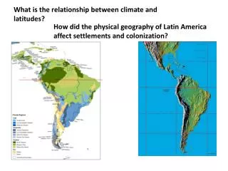
What is the relationship between climate and latitudes?. How did the physical geography of Latin America affect settlements and colonization?. Note the climate of Panama. Panama has two seasons. A hot, wet season, and a hot, dry season. The dominant landforms in Panama are:.

E N D
What is the relationship between climate and latitudes? How did the physical geography of Latin America affect settlements and colonization?
Panama has two seasons. A hot, wet season, and a hot, dry season.
The land of Panama is a loose and sandy soil. What is the problem going to be when trying to dig through it?
Because the land rises to the center of the country, it is almost impossible to dig a canal straight through. The solution?
Knowing this is a tropical region and the time frame is the early 1900’s, what health hazard made building the canal almost impossible?
In order to hold the diseases at bay, the breeding grounds have to be destroyed, generally covered with a film of an oil based product.
CONFLICT IN KASHMIR - Kashmir has been a source of conflict between India and Pakistan since independence in 1947. When the parts of “British India” decided to join India or Pakistan, the ruler of Kashmir was a Hindu but the majority of the population was (and still is) Muslim. The maharajah of Kashmir chose to join India.
There is almost a constant state of war in Kashmir. There is a large and powerful terrorist Islamic group fighting the Indian army. The people of Kashmir would actually prefer to be independent, but neither India or Pakistan will allow it. Since they are majority Muslim, why won’t India let them go? India is made up of several regions that would love to break away. They fear a “domino theory” situation where if one breaks away, others will as well.
India and Pakistan have fought several wars in the past 50 years, but Kashmir has not changed hands. The big issue now is that both countries have nuclear weapons. The solution? There is none in sight.
TO BUILD OR NOT TO BUILD? In CHINA, ITS NOT REALLY A QUESTION. The Three Gorges Dam
Location of the Three Gorges Dam. What is a “reservoir?” A man made body of water.
The Three Gorges Region of China A perfect avenue for flood waters. A gorge is a narrow, steep walled canyon
Construction of the dam 2005 1987
The city is some 1,200 miles from the sea. The “new” city of Chongqing is home to nearly 30 million people. Similar to the population of California. It is the home to a large port and numerous factories, including the Zhineng motorcycle company.
Negative results of the dam. Population relocation. Over a million people are having to leave the villages their families have lived in for centuries.
The dam today is a reality and is nearing completion this year (2009) The three Gorges Dam
Large scale transportation in Africa The most cost effective way to ship goods is?
With many large rivers in Africa, large ships should be able to move deep into the interior. Movement Africa’s great rivers.
How does the physical geography of Africa limit transportation? Note the narrow coastal plain (light green.)
There are many rivers similar in size to the great rivers of Europe and North America, yet it was difficult for ships to sail to the interior. Because it is a plateau, the major rivers have waterfalls and “cataracts” (rapids) that prohibit travel by large ships. Where is the “fall line” in the USA?
The Sahel is a band that borders the southern Sahara. A combination of drought and human development is turning weak grasslands into desert. This process is called?