Download
1 / 53
530 likes | 632 Views
Explore the geological history of Butt Mountain at the proposed Butt Mountain Deep Underground Science and Engineering Laboratory site in Virginia. Discover the region's stratigraphy, tectonic structure, and geological evolution.

E N D
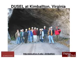
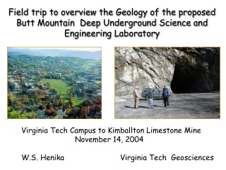
Field trip to overview the Geology of the proposed Butt Mountain Deep Underground Science and Engineering Laboratory Virginia Tech Campus to Kimballton Limestone Mine November 14, 2004 W.S. Henika Virginia Tech Geosciences
The Kimballton Mine is located in the Allegheny Mountains of southwestern Virginia, near the western edge of the Appalachian Valley and Ridge Physiographic Province.
Valley and Ridge Topography Reveals Some 300 Million Years of Geological History. BUTT MOUNTAIN
BUTT MOUNTAIN IS LOCATED ON THE NARROWS OVETHRUST SHEET RegionalTectonic Map The Valley and Ridge overthrust structure reflects intense compression along the proto- Atlantic Continental margin during the Alleghenian collision event between North America and Africa. The collision created the Pangean super continent some 300 million years ago. Our present mountains are much younger, having formed by erosion in the post Cretaceous era.
The break up of Pangea began in the Triassic Period about 245 million years ago and by the Jurassic Period continental rifts forming the Atlantic and Gulf of Mexico Ocean basins were well established.
The modern Appalachian Mountains are forming by gentle uplift, rejuvenation and entrenchment of rivers along the eastern flanks of the Atlantic Basin.
Butt Mountain is on a passive Continental margin. Differences in the scale between the ancestral Appalachian structures and the current structure of the eastern North American Plate is strikingly portrayed in this view of the Atlantic Ocean Floor. BUTT MOUNTAIN
Regional Cross Section Allegheny Plateau Valley and Ridge BUTT MTN Butt Mountain is a large synclinal mountain near the western edge of the Valley and Ridge. This region is characterized by linear ridges held up by tilted strata of resistant sandstone with limestone and shale in fault line valleys. Access to outcropping sedimentary strata allows excellent surface structural control based on contrasting stratigraphy.This will also prove to be an asset in designing and exploring laboratory sites in the subsurface.
Regional Stratigraphic Column From Cooper, 1961 Stop 8 Stops 2&9 Stop 7 Stops4&9a Stop 1 Stop 5
Geology for the Butt Mountain Area, Giles County, Virginia showing section lines DIGITAL GEOLOGIC MAP OF THE RADFORD 30X60 MINUTE QUADRANGLE, VIRGINIA AND WEST VIRGINIA Geology by Mervin J. Bartholomew, Arthur P. Schultz, Sharon E. Lewis, Robert C. McDowell, and William S. Henika 2000
Stereographic Projections of Poles to Bedding Statistical studies of field data by Professor Rick Law. Stereographically derived fold axes (B) help to provide geometrical constraints on the geological model of both the Bane and the Butt Mountain fold structures.
Geology for the Butt Mountain Area, Giles County, Virginia showing section lines DIGITAL GEOLOGIC MAP OF THE RADFORD 30X60 MINUTE QUADRANGLE, VIRGINIA AND WEST VIRGINIA Geology by Mervin J. Bartholomew, Arthur P. Schultz, Sharon E. Lewis, Robert C. McDowell, and William S. Henika 2000
This detailed geologic cross section was based on regional seismic subsurface and detailed geologic field data. The cross section follows a model commissioned by the Appalachian Basin Industrial Associates and published by Nicholas Woodward and David Gray in 1985. The model has been used to locate exploratory seismic profiles andexploration wells for the VT DUSEL Project.
3-d surface model by Jason Shelton, VT College of Engineering
BUTT MOUNTAIN DUSEL SITE 3-d model by Jason Shelton, VT College of Engineering Based on cross sections by W.S. Henika
Stop 1- Cloyd Conglomerate on Brush Mtn Burr stones quarried from Cloyd Conglomerate in open pits along on Brush Mountain were shipped all over the world. Millstone production began in the 1750s and continued until the 1950s!
Stop 1- Cloyd Conglomerate on Brush Mtn The conglomerate exposed on Brush Mountain in the road base along U.S. Route 460 is an extremely tough silica cemented quartzite. The Cloydy crops out nearly1000 feet below anthracite coal beds mined in the Valley Anthracite Field
Stop 2- Silurian Quartzite on Gap Mtn Tuscarora Fm
Stop 2-Base of Silurian on Gap Mtn The Ordovician-Silurian sandstone and shale section is a major seismic reflector on Appalachian seismic profiles.
Stop 3 - Lower Martinsburg Fm Interbeds of Reedsville sh and Trenton Ls in the Lower Martinsburg have been recognized as a major decollement.
Stop 3b – Lower Martinsburg Fm Weathered sh and ls saprolite overturned along the Saltville fault zone.
Stop 4 – Middle Ordovician Limestone Massive carbonate clastics are part of a transgressive sequence that flooded the exposed Knox carbonate shelf
Covered Bridge over Sinking Creek along Mtn Lake Road between stops 4 and 5.
Stop 8-Millboro Shale on Butt Mountain A major petroleum source bed and detachment zone
Chemical Limestone Corporation is mining the Middle OrdovicianFive Oaks Limestone at the Kimballton mine
Butt Mountain Seismic Line 1 was shot along this Forest Service logging road
Butt Mountain Seismic Lines Line 2 Line 1
H BUTT MOUNTAIN DUSEL SITE Butt Mtn Seismic Line 1 Interpreted by Adam Schumaker-VT Geosciences 3-d model by Jason Shelton VT College of Engineering
Anticlinal Rollover on Thrust Exposed Along SR 630 About One Mile South of Kimballton