Download
1 / 12
120 likes | 251 Views
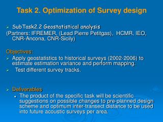
Task 2. Optimization of Survey design. SubTask2.2 Geostatistical analysis (Partners: IFREMER, (Lead Pierre Petitgas), HCMR, IEO, CNR-Ancona, CNR-Sicily ) Objectives: Apply geostatistics to historical surveys (2002-2006) to estimate estimation variance and perform mapping.

E N D
Task 2. Optimization of Survey design • SubTask2.2 Geostatistical analysis (Partners: IFREMER, (Lead Pierre Petitgas), HCMR, IEO, CNR-Ancona, CNR-Sicily) Objectives: • Apply geostatistics to historical surveys (2002-2006) to estimate estimation variance and perform mapping. • Test different survey tracks. • Deliverables • The product of the specific task will be scientific suggestions on possible changes to pre-planned design scheme and optimum inter-transect distance to be used into future acoustic surveys per area.
Northern Aegean Sea survey • Split Beam Biosonics DTX echosounder at 38 kHz • Parallel transects perpendicular to bathymetry, zig zag in gulfs • 10 nm inter-transect distance • Daytime echo collection • 25-30 days required to cover the entire area • 9 000 NM2/ 31.000 Km2 • EDSU was 1 nm
Due to area complex topography and the patchy distribution of the target species: • Need for area stratification • Increase sampling effort in areas of high abundance? • Division based on physical or biological reasons (e.g. topography, bathymetry, differences in the population characteristics) • Parallel transects perpendicular to bathymetry with 10 nm inter-transect distance • zig zag in gulfs
HCMR work on geostatistical analysis • Software used: EVA2, Variowin, Splus, Surfer for krigging and mapping • Total NASC values (2003-2006) • NASC values of anchovy and sardine (2003-2006) • Intrinsic variograms calculated per year and subarea • range, sill and nugget estimations are available • geometric anisotropy examined
2004 2005 2006 2008 Anchovy Distribution maps
2004 2005 2008 2006 Sardine Distribution maps
2008 2005 2006 Nasc Histograms: anchovy
Nasc Histograms: sardine 2008 2006 2005
Geostatistical analysis results • Practically what we have done is stratifying the area into homogeneously sampled areas and applied different structures to each stratum • Anchovy, ln(NASC+1) range: indicates the maximum size of fish patches sill/nugget: percentage of variance explained by the spatial pattern Thracian Sea West Thracian Thermaikos North Evoikos Gulf
Geostatistical analysis results • Sardine, ln(NASC+1) Thracian Sea North Evoikos Gulf West Thracian Thermaikos
Questions concerning the analysis and the peculiarities of Aegean Sea • Is there any alternative to analysis by stratum? • Existing topography does not allow much changes in the zig zag survey design, what are the alternatives? • In some cases strong geometric anisotropy is present. How can this be taken into consideration within the survey design? Generally: • Shall we apply intrinsic and • transitive geostatistics
Work organised with 3 workshops: • at kick-off meeting (23-24 March 2010) • by month 12 ( November 2010, Palma) • by month 21