Download
1 / 29
670 likes | 1.72k Views
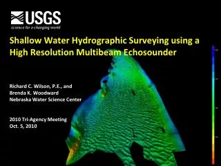
Shallow Water Hydrographic Surveying using a High Resolution Multibeam Echosounder. Richard C. Wilson, P.E., and Brenda K. Woodward Nebraska Water Science Center 2010 Tri-Agency Meeting Oct. 5, 2010. Hydrographic Surveying. Aristotle observed that sound could be heard in water

E N D
Shallow Water Hydrographic Surveying using a High Resolution Multibeam Echosounder Richard C. Wilson, P.E., and Brenda K. Woodward Nebraska Water Science Center 2010 Tri-Agency Meeting Oct. 5, 2010
Hydrographic Surveying • Aristotle observed that sound could be heard in water • Allies invent the sonar during World War I • Coast and Geodetic Survey deployed the Fathometer in 1925 • U.S. Navy deployed a multibeam echosounder in the 1960s
Hydrographic Surveying - Purposes • Navigational aide • Quantity surveys • Inspections of dams, bridges, and water control structures • Habitat assessments • Hydrodynamic and sediment-transport models • Geomorphic assessments
Multibeam Hydrographic Surveying • Wide yet narrow swath perpendicular to the boat direction • Multiple beams in just one ping • SURVEYS the ENTIRE RIVER or LAKE BED
Shallow Water Multibeam Hydrographic Surveying • Minimum depth is 1 meter • Swath angle 128° or width-to-depth ratio 3.5 to 1 • Rotation of the transducer for surveying horizontal features • Use Single and Multibeam Echosounders, together • Flat keel boat • Obstructions
RESON Seabat 7125 Multibeam Echosounder System • Digital beam-former • 400 kHz • 256 or 512 beams • 128° swath angle • 200 meter range • Bathymetry data and Side-Scan imagery
Multibeam Echosounder Components Projector Array Sound Velocity Probe Receiver Array
Multibeam Echosounder Components Real-Time Kinematic Global Positioning System (RTKGPS) or Differential Global Positioning System (DGPS) Inertial Measurement Unit (IMU) Sonar display Navigation computer Position and Orientation Solution (POS-MV) motion control unit 7-P sonar signal processor
Patch Test Calibration Roll correction Pitch correction Yaw correction Nadar Beam
Multibeam Data Processing • Dell Precision T7500 • Intel Xeon Quad Core Processor 3.46 GHz • 12GB DDR3 SDRAM, 1333MHz, • 2 GeForce GTX 480 2.0 • Graphics Card
Multibeam Data Processing Line-by-line swath editing is necessary
Gavins Point Dam Multibeam Survey • Purpose: • Document change from 1957-2008 • Verify the integrity of energy dissipation structures • Create updated bathymetric contours
Energy Dissipation Structures • Determined the • structural integrity • Divers were not needed, eliminating a safety hazard • Measured change to 0.1 M
Missouri River Bends Missouri River Habitat Assessment and Monitoring Program (HAMP) • Habitat improvement through structure modification • Wing dike notches • Chevrons • Parallel dikes • Revetment removal
Hydrographic Surveys of Glovers Bend Single-beam echosounder Glovers Bend, Missouri River 2007
Hydrographic Surveys of Glovers Bend Multibeam echosounder Glovers Bend, Missouri River 2009
Experimental Advanced Airborne Research LiDAR (EAARL) Water penetrating LiDAR Uses Blue-green laser NASA/USGS Technology Shallow water EAARL survey, Central Platte River
Side-Scan Sonar: Using Backscatter Intensity to Classify Substrate
CONTACT INFORMATION: Rick Wilson USGS Nebraska Water Science Center (402) 328-41205231 South 19th St. wilson@usgs.govLincoln, NE 68512-1271 http://ne.water.usgs.gov Robert B. Swanson Director (402) 328-4110 rswanson@usgs.gov Richard C. Wilson, P.E. Associate Director of Hydrologic Studies (402) 328-4120 wilson@usgs.gov Ronald B. Zelt Associate Director of NAWQA Studies (402) 328-4140 rbzelt@usgs.gov Jason M. Lambrecht Associate Director of Hydrologic Data (402) 328-4124 jmlambre@usgs.gov